- Place
- Sudervė Eldership, Vilnius District Municipality
- Region
- Neris Regional Park
- Type
- a low-flow erosional spring with continuous discharge
- Address
- Rastinėnai-Bubos garden-community boundary, eastern edge of Elniakampis Forest, Sudervė Eldership, Vilnius District
- Coordinates
- 54.77218, 24.99986
- Visit duration
- about 30-60 minutes; longer if combined with a woodland walk
- Best time
- a bright, dry season; after rain the slope and wooden structures can be slippery
Rastinėnai Spring is at the eastern edge of Elniakampis Forest
Rastinėnai Spring lies by the boundary of the Rastinėnai and Bubos garden communities, at the eastern edge of Elniakampis Forest and beside the Neris Regional Park setting. The Lithuanian Geological Survey includes it in its spring descriptions and places the source in a small pine-forest clearing beside the road.
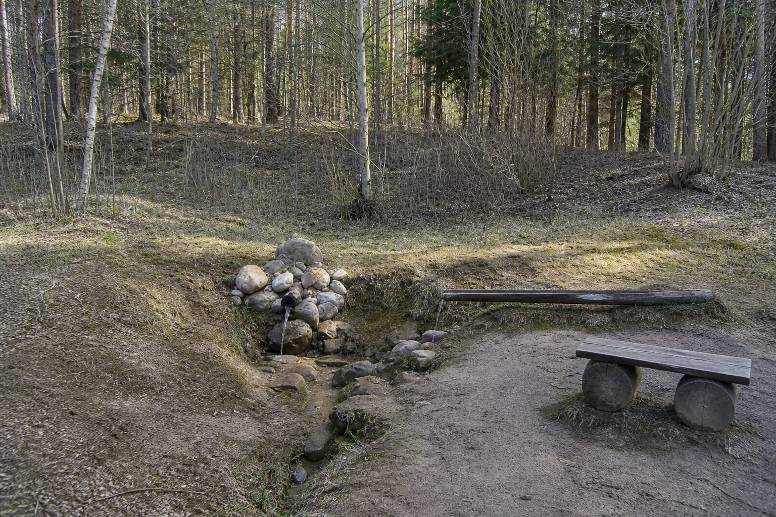
This is not a large waterfall or a built park. The spring emerges from a shallow slope hollow, and a small flow runs down into a lower, damp and locally boggy hollow. The Survey describes Rastinėnai Spring as a continuously flowing, low-discharge falling erosional spring.
The map point uses the LKS-94 point given in the Survey document, converted to WGS84 coordinates. It marks the spring itself, not the whole garden-community road network or a guaranteed place to park a car.
A short spur leads to the source from the road
The Survey says to approach from the western end of the garden community's bus turnaround, along the road towards Šiurmonys. A short spur leads from the road to the spring; the document describes an arrow and a sign indicating 50 metres to the source. Follow signs present on the day and do not block the turnaround.
The source was described as having an information board, bench, trodden path, and a wooden channel directing the water. A lower sheet-metal channel and plank were also recorded as helping visitors approach the flow. Such structures are sensitive to moisture, frost, and maintenance changes, so do not climb on or rearrange them.
At the garden-community edge, distinguish the public road from private plots. Keep to the existing spur, do not cross yards, and if the road is closed or the ground is saturated, choose a safe place to turn back and continue on foot only where access is clear.
Slope water movement shaped the spring
The Survey describes the source as emerging in a shallow slope hollow, a suffosion cirque. It is about 125 metres above sea level, a little more than two kilometres from the Neris, and about 57 metres above the river.
The water runs west-southwest and, through erosion, descends into a shallower low place. At the site you can therefore see not only a water point but also a small damp runnel whose shape responds to rainfall, frost, and local maintenance.
Neris Regional Park is a landscape of forests, valleys, ravines, and terraces. The spring is a small element of this wider hydrological setting and is best visited quietly, without trying to alter the water's natural course.
Old water data is not a current drinking-water approval
The Survey document records measurements from 2014: the sample was transparent and odourless, about 6.7°C, mildly alkaline, and of moderate mineralisation. These figures help explain the spring's historical hydrochemical description, but they do not say what the water condition is today.
Historical measurements should not be treated as a current drinking-water safety test. Do not drink the water merely because it looks clear, give it to children or pets, or repeat unverified claims about healing properties. Current use would require recent competent-authority testing and guidance.
Local stories connect springs with living or life-giving water. That is cultural memory and folklore, not a medical conclusion. Protect the banks, do not wash chemically treated containers at the source, and leave no waste.
A quiet visit fits a short Neris Park outing
Rastinėnai Spring works well as a short stop to observe the source, wooden channel, and pine-forest edge. Allow enough time to walk the spur slowly, read local information, and return the same way instead of forcing a route through the wet low ground.
After rain, the slope, plank, and edge of the water runnel may be slippery. Wear shoes with good grip, keep young children close, and handle dogs so that they do not damage the slope or disturb wildlife.
If you continue the outing, choose a separate Neris Regional Park site and check its access independently. The spring's map point does not confirm that every nearby forest track is public or suitable for cars.