- Place
- Kurmaičiai, Mažeikiai District Municipality
- Region
- Samogitia
- Type
- a 50-metre single-span riveted steel railway truss with two four-storey red-brick guardhouses and surviving embankments
- Address
- 12 Geležinio tilto Street, Kurmaičiai, Mažeikiai District
- Coordinates
- 56.33905, 22.23857
- Visit duration
- 20-35 minutes to view the complex from lawfully accessible ground-level positions; climbing onto the old bridge, entering the guardhouses, or approaching the active tracks is not included
- Best time
- a bright, dry day from late spring to autumn, when the truss, both guardhouses, and the Venta channel are easier to see from a safe bank
Kurmaičiai Railway Bridge, Old Railway Bridge over the Venta, Old Mažeikiai Railway Bridge, Geležinkelio tilto statinių kompleksas
A protected old bridge and an operational modern bridge stand side by side at Kurmaičiai
The Venta Railway Bridge Structures Complex lies at Kurmaičiai, about 7 kilometres northwest of Mažeikiai. The address at 12 Geležinio tilto Street and the coordinates 56.33905, 22.23857 identify the complex itself, not an official car park or an authorised entrance onto the bridge. Mažeikiai District Municipality announced that an information panel with a QR code had been installed at the site in 2025.
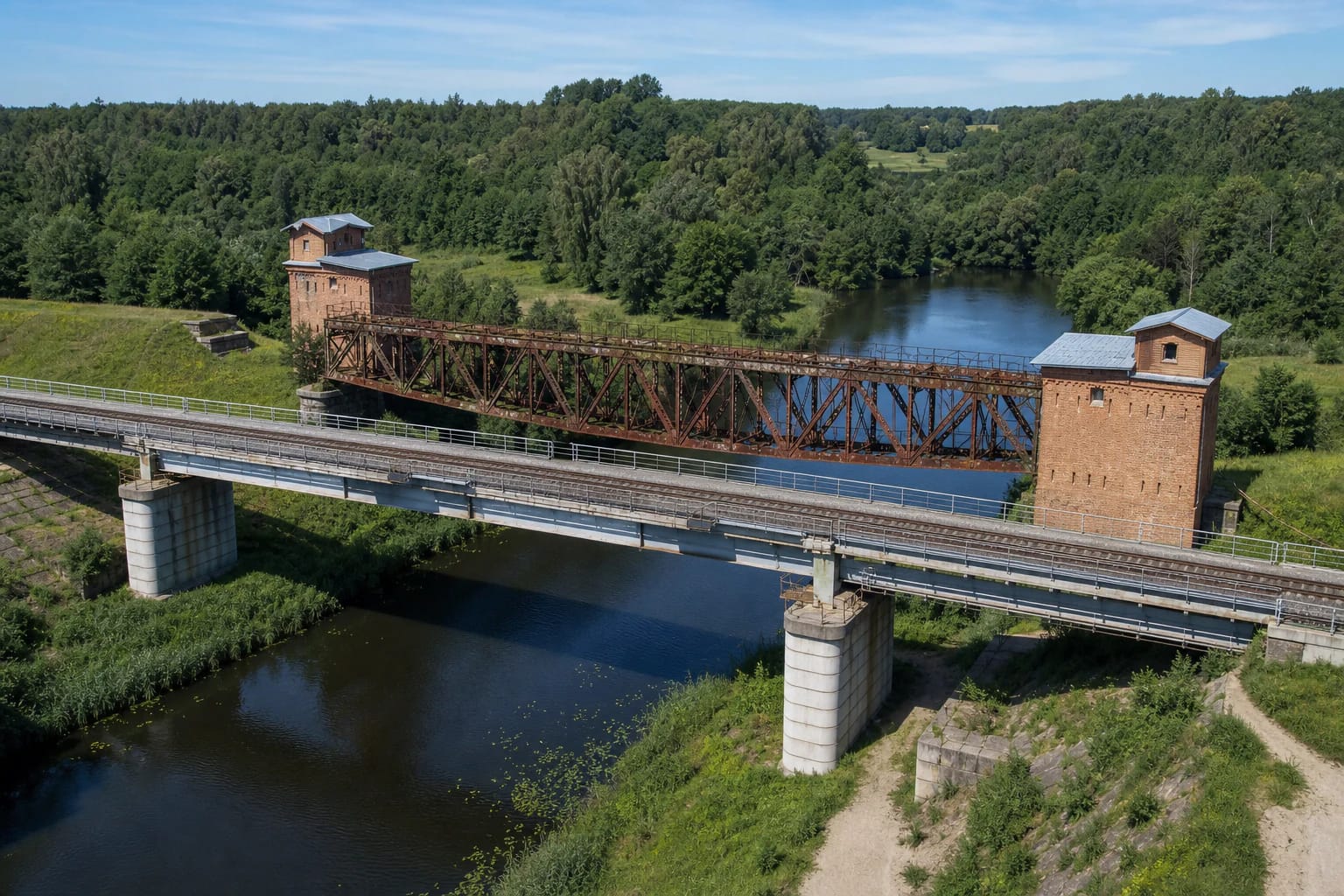
The first task on arrival is to distinguish two separate structures. The rust-stained old bridge framed by brick guardhouses is disused, and its rails no longer survive. Rail traffic runs across the newer grey bridge constructed immediately beside it. The newer bridge, tracks, embankment, and service approaches are not a visitor trail.
The protected complex has KVR code 31139. Its independently registered components are the railway bridge, code 31140, the eastern guardhouse, code 31141, and the western guardhouse, code 31142; two railway embankments on either bank of the Venta are also listed among its valuable features. The defined 1.41-hectare site is protected at regional level.
The story from the temporary crossing of 1871 to the metal structure of 1918 cannot be reduced to one date
VLE dates construction of the Liepāja-Romny railway through Mažeikiai, Radviliškis, Kėdainiai, and Kaišiadorys to 1871-1873. The line carried grain from Ukraine towards the port of Liepāja. KVR dates the Kurmaičiai complex as a whole to 1871-1875 and associates it with the railway's Liepāja-Kaišiadorys section. Research by Mažeikiai museum specialist Vytautas Ramanauskas describes a temporary Venta crossing photographed by Konrad Brandel as early as 1871, so the metal visible today cannot simply be treated as the first bridge's original fabric.
Local historical accounts say that a stronger timber railway bridge was built across the Venta in 1904-1905 and destroyed during First World War fighting in April 1915. The sources disagree over who carried out the destruction: some name German troops, while another attributes it to retreating Russian units. No dependable document resolving that contradiction was found for this guide, so neither force is presented as conclusively responsible.
The bridge was rebuilt with metalwork in 1918, and local accounts associate the brick guardhouses with that phase. KVR nevertheless retains the broad 1871-1875 date for the present registered components, while its 2007 act says historical and architectural investigation is required before conservation work. A new bridge was built alongside late in the twentieth century, after which rail traffic moved to the newer structure.
Four stone supports carry the 50-metre truss, while four-storey guardhouses mark its ends
KVR describes the bridge component as a 50-metre, single-span truss with two supports at the foot of the embankments and two above. Its protected fabric includes four supports built of dressed, rusticated stone with concrete cornices and riveted steel trusses. The old rails and some steel elements are missing, so the open deck must not be mistaken for a pedestrian bridge.
Both guardhouses are rectangular, tower-like buildings of four storeys above a plinth. KVR identifies load-bearing red-brick walls, wedge-shaped masonry lintels, moulded cornices, a frieze, fourth-floor gables, window surrounds, and shallow pilaster strips. The bases are dressed stone, while the internal floors use masonry jack arches carried on metal beams. A modest gabled roof covers the smaller fourth level.
KVR's condition assessment from 2007 classed the steel trusses and guardhouse volumes as poor, while parts of the masonry were satisfactory. This is a dated heritage survey, not a 2026 structural inspection. It provides no basis for assuming that touching the structure, entering an opening, or walking across the exposed old deck is safe today.
Independent Lithuania's first Venta water-gauging station operated beside the bridge
A Klaipėda University study of hydrological history reveals a less familiar chapter. On 2 November 1924, the first Venta water-gauging station established by independent Lithuania opened beside the old railway bridge at Pumpurai, now part of Kurmaičiai. Hydrometric observations continued here without interruption for 18 years.
The study also considers earlier measurements connected with renewed surveys for the Venta-Dubysa canal in 1902-1905 and a reference to water levels recorded in 1875. Its authors stress that more archival research is needed to establish the sequence of the Imperial Russian stations. The 1924 foundation is therefore the firm starting point for independent Lithuania's network, while any claim to an earlier first station remains a research question.
This episode shows why the location mattered beyond the railway. Bridge supports offered a stable reference for recording water level, while the railway made the measuring point easier to reach. When viewing the complex, take in the truss, the Venta channel, and the high embankments together: KVR protects precisely that relationship as engineering and landscape heritage.
Ghost stories and claims of mass executions are not documented history of the complex
Online retellings say that soldiers haunt the bridge, gunshots can be heard, or several thousand people were executed nearby. Even the local tourism description presents these claims as circulating stories and possible myths rather than verified archival facts. No confirmation of such a mass execution was found in KVR, municipal information, or the museum and academic sources reviewed for this guide.
The narrow openings in the brick guardhouses and the site's strategic position understandably invite military interpretations. KVR, however, records them more carefully as wall openings with wedge-shaped masonry lintels and does not establish that every aperture was a machine-gun position. Nor can individual marks in the brickwork be assigned to a particular war or battle without specialist investigation.
Atmosphere and oral tradition may form part of a visit, but they must remain separate from the documented chronology. Construction of the railway, wartime destruction, rebuilding in metal, the protected fabric, and the water-gauging station are supported by evidence. Stories of ghosts and thousands of victims are identified here as unverified legends.
View the complex from the bank and information panel, never from the tracks or exposed old deck
The complex is not a museum with a ticket office, fixed visitor hours, or advertised regular tours. The information panel and exterior visible from lawfully accessible places may be viewed without charge, but that does not grant unrestricted entry across the entire 1.41-hectare protected site. Check the latest Mažeikiai District Municipality information, local signs, barriers, and seasonal conditions before travelling.
Do not climb onto the old bridge, enter either guardhouse, or try to reach the structures along the embankments. The adjacent new bridge belongs to an active railway. LTG Infra instructs pedestrians to cross railways only at designated crossings or level crossings; never improvise a shortcut over the tracks here, stand on the formation, or lose awareness of your surroundings while taking photographs.
No official audit of parking, step-free access, or path surfaces has been published. The approach and riverbank can be uneven, muddy, or overgrown, and the map pin does not guarantee a parking bay. Leave a vehicle only where current signs permit and local traffic remains unobstructed. Choose a dry, bright period for a safe 20-35 minute exterior stop, then continue to Mažeikiai Museum or another industrial-heritage site in the district.