- Place
- Kėdainiai District Municipality
- Region
- Aukštaitija
- Type
- urban pedestrian and cycle bridge
- Address
- Didžioji g.–Č. Milošo g., Kėdainiai
- Coordinates
- 55.28551, 23.98310
- Visit duration
- 20–40 minutes; longer if you cross it slowly, study the relief and stay by the river
- Best time
- blue hour and evening for the lights, daytime for structural detail and the Old Town riverfront
Kėdainiai Pedestrian Bridge
A bridge between Kėdainiai’s riverbanks
The Pedestrian Bridge over the Nevėžis links the Kėdainiai Old Town side near Didžioji Street with the Č. Milošo Street approach on the opposite bank. It is a public crossing for pedestrians and cyclists, so it belongs in a walking route rather than being viewed only from the shore.
The official Kėdainiai tourism description calls it the Pedestrian Bridge over the Nevėžis. The Old Town qualifier is useful context, but not part of the formal name: this is the particular bridge crossing the river.
The 2018 timber-and-steel truss
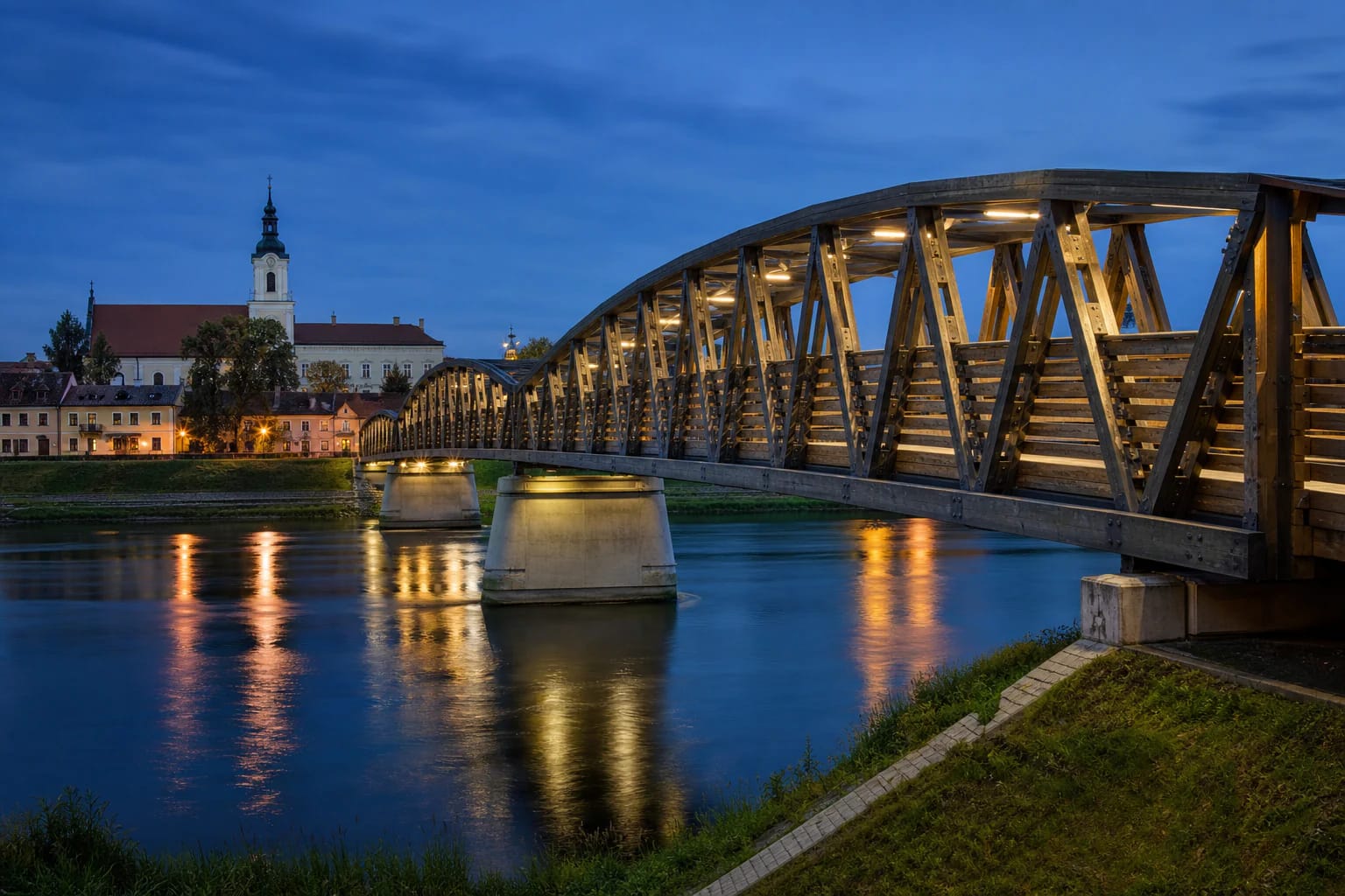
The current bridge was built in 2018. It is 96 m long and 3.66 m wide, and its timber-and-steel truss rests on concrete supports. A curved upper beam creates a distinctive tunnel-like feeling above the walkway, giving the crossing more spatial character than a simple straight footbridge.
Look at the construction as you walk: the timber deck, diagonal trusses and piers continually change the frame. It remains a city-scale structure designed for everyday movement, rather than competing with the historic architecture on the riverbank.
Aukštaitija and Samogitia in the bridge details
Kėdainiai tourism information presents the bridge as a link between the historic lands of Aukštaitija and Samogitia. Their coats of arms are installed on the pylon structures at the two banks, turning a geographic idea into a visible part of the walk.
A bronze relief of the 1831 Battle of Kėdainiai by sculptor Mindaugas Junčys is set into the northern pylon on the right bank. Look for it while crossing: it is a small but precise piece of city history easy to miss when hurrying through.
From a crossing mentioned in 1602 to today
A bridge at this Nevėžis crossing is mentioned as early as 1602. The current truss is the latest stage of the same urban link, so the place’s story is not only about the 2018 build. Kėdainiai’s riverbanks have changed over the centuries, while the crossing continues to connect daily movement with memory.
The bridge has functional lighting: LED lines highlight the trusses and supports, and decorative lighting may be used for celebrations. The light setting can change, but blue hour is a good time to see the structure’s silhouette and reflections in the Nevėžis.
A practical walk across the Nevėžis
The map point 55.2855083, 23.9830972 marks the bridge crossing between Didžioji and Č. Milošo streets, not the nearby square or another Nevėžis bridge. Check for temporary works or closures before travelling because this remains an active public link.
No dedicated parking or toilet is clearly marked at the bridge, and step-free approaches and lighting can differ by bank. Keep the path clear while photographing, take care near the river edge, and never climb the truss.