- Place
- Tauragnai, Utena District Municipality
- Region
- Aukštaitija National Park
- Type
- developed recreation area on Lake Tauragnas with viewing piers and a separate boat-mooring pier
- Address
- Western shore of Lake Tauragnas, Tauragnai, Utena District
- Coordinates
- 55.44254, 25.82406
- Visit duration
- 1-3 hours for the shore, piers, a picnic, and time beside the water
- Best time
- a warm day from late spring to early autumn; choose a morning or weekday for a quieter view
Tauragno Slėnis, Tauragno Slėnis Rest Area, Lake Tauragnas Shore Recreation Area
A particular access point, not another name for the whole lake
The recreation area lies beside Tauragnai on the western side of the long, narrow Lake Tauragnas. Its exact map entry marks 55.4425396, 25.8240602. It is one developed section of the lakeshore, so its facilities should not be attributed to all 24.3 kilometres of the lake's winding shoreline.
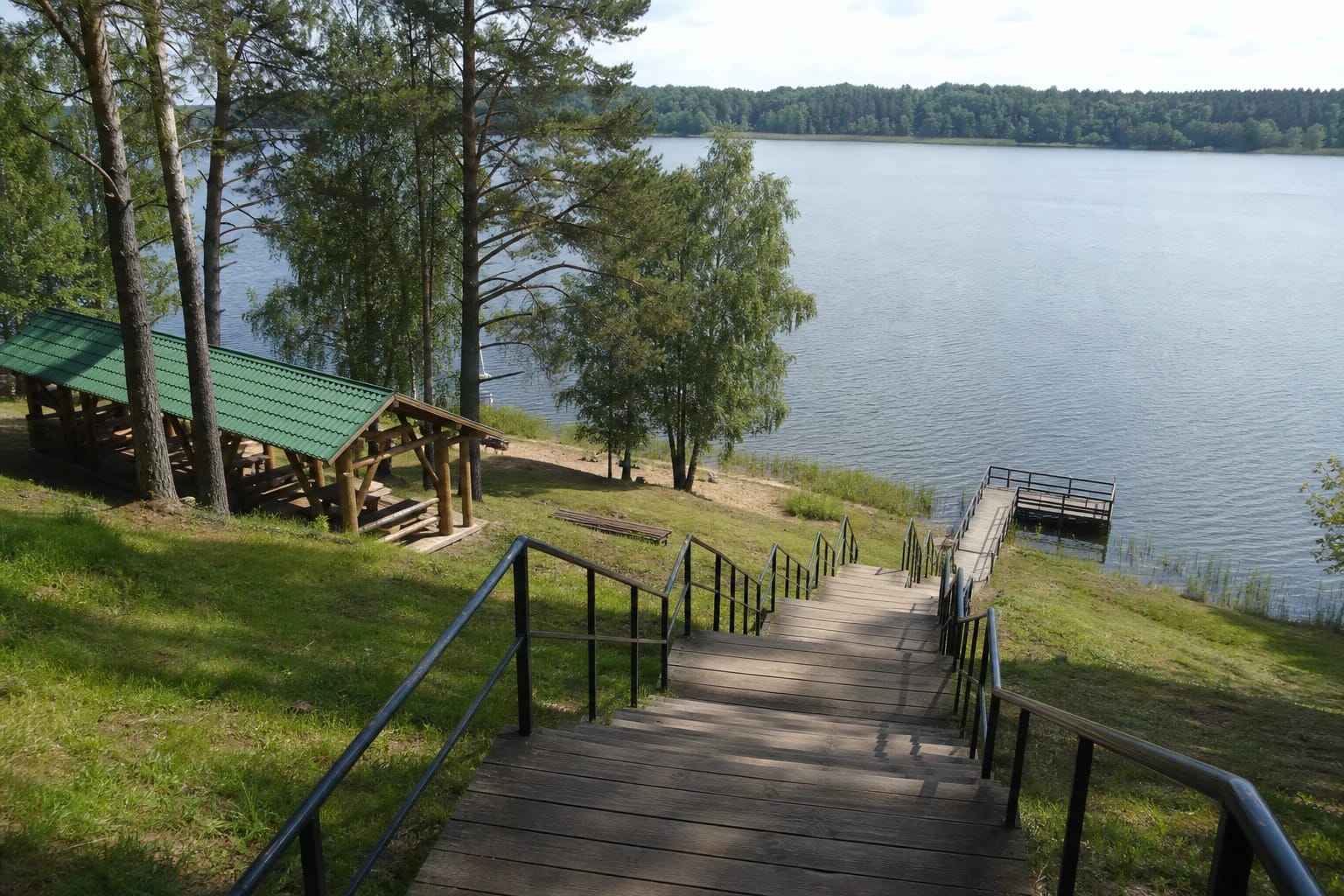
The place unfolds vertically. Visitors park in a car park above the shore, while maintained paths and a staircase with intermediate landings descend toward the water. Real views show green lawns, mature coniferous and deciduous trees, timber structures, and a narrow reach of lake opening between wooded banks.
The slope is part of the visit, not merely a backdrop. The return involves a climb, while timber steps and grass can become slippery after rain. Sturdy shoes with good grip are more useful here than beach flip-flops.
Two piers for views and a third for boats
The official Tauragnai description clearly distinguishes the functions of three pontoon structures. Two have viewing platforms from which visitors can look along the lake and across its wooded shores. A third pontoon pier provides a place for mooring boats.
Decking, rails, and connections are outdoor infrastructure affected by water level, ice, and seasonal maintenance. If a barrier or restriction is displayed, do not use the structure simply because an older photograph shows it open.
A mooring point does not automatically make the pier a public boat-launch ramp or permit any vessel to remain there indefinitely. Check signs and protected-area requirements before arriving by water, and leave shared access clear.
Three shelters and practical facilities for families
The shore contains three large timber shelters, outdoor furniture, a beach-volleyball court, changing cabins, and a children's playground. Lighting is also installed. This exact combination distinguishes Tauragno Slėnis from an informal stop elsewhere on Lake Tauragnas.
The shelters are suitable for a short picnic or shelter from light rain, but belongings should not be used to reserve the whole space. Summer weekends can be busy, so larger groups should have a fallback plan and keep paths and stairs open.
The checked official description does not list toilets, drinking water, showers, or a permanently operating food outlet. Do not plan around those services as guaranteed, and use a fire or barbecue only where signs and purpose-built equipment explicitly allow it.
Recreation beside Lithuania's deepest lake calls for care
VLE identifies Tauragnas as Lithuania's deepest lake, with a maximum depth of 62.5 metres, an average depth of 18.4 metres, and an area of 503.3 hectares. The record belongs to the lake as a whole and does not mean that this depth begins beside the recreation-area piers.
A more relevant detail for visitors is VLE's description of a narrow littoral shelf. Depth changes, the lake bed, and water temperature can vary at an individual entry point, so never jump from a pier before checking conditions. No permanent lifeguard schedule was found in the checked official sources.
Keep children within reach beside the water and use life jackets in a boat. Leave pontoon structures and return to shore during strong wind, a storm, or thunder.
Planning a visit without misreading the published office hours
The official description does not publish separate visitor hours or an admission charge for the recreation area. The timetable displayed on the same webpage sits beside Tauragnai eldership contact details, so it is not evidence that the lake shore opens or closes at those times.
Allow 1-3 hours. The shorter visit is enough to descend to the piers and see the lake; a picnic, playground stop, or volleyball requires longer. Check the weather, signs, and latest official information before travelling because seasonal infrastructure can close for maintenance.
Use the marked car park rather than grass or an access road. The official source mentions paths and stairs but does not document a continuous step-free route to the water, so visitors with specific mobility requirements should confirm the current arrangement in advance.