- Place
- Joniškėlis Eldership, Pasvalys District Municipality
- Region
- Aukštaitija
- Type
- a state-protected geological natural-heritage object and Devonian dolomite outcrop
- Address
- Stipinai village, Joniškėlis Eldership, Pasvalys District
- Coordinates
- 56.06590, 24.11352
- Visit duration
- 30-60 minutes; longer if access is safe and you explore the Mūša valley
- Best time
- a dry, bright season; roads, slopes, and old stair sections can be slippery or inaccessible after rain
Skalių Kalnas, Skalių atodanga, Stipinai Outcrop
Skalių Kalnas is an outcrop in the Mūša valley, not a separate mountain
The protected-object name is Atodanga Skalių kalnas. Local people and travel descriptions also call it Skalių Kalnas or Stipinai Outcrop because the dolomite layers form a distinct steep slope on the Mūša bank. It stands in Stipinai village, Joniškėlis Eldership, on the river's right bank.
Saugoma.lt publishes the rounded point 56.066, 24.114, while the municipal geological-object project and map material use the more precise 56.065902, 24.113519. The coordinate on this page marks the outcrop itself, not a single car park or a convenient descent to the river.
The outcrop lies in the surroundings of the Mūša Valley botanical reserve and a habitat-protection area. Visit quietly and carefully: do not break the layers, collect stones, stand on the cliff edge, or shorten the approach across private fields.
A 45-metre rock section exposes layers from a Devonian sea floor
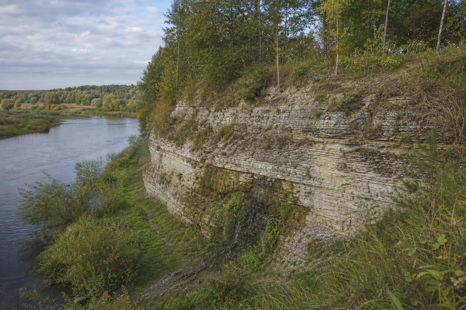
The Pasvalys District Municipality project describes Skalių Outcrop as about 45 metres long, 6 metres high, and 0.083 hectares in area. Another description emphasises a steep slope of roughly 7 metres falling towards the Mūša. The 6-metre outcrop height and 7-metre slope should not be forced into one identical measurement.
The protected purpose is to preserve carbonate sediments that accumulated on a sea floor about 350 million years ago. Stipinai Formation dolomite is exposed in the upper section, above carbonate-clayey Pamūšis Formation layers. The grey or yellow-grey rock now looks like a riverbank cliff, but its story began long before the present Mūša valley.
The rock contains described traces of pyrite and limonite, shell remains, and cavities. This is not a decorative-stone quarry or a place to split or carry away pieces: the continuity of the layers is the protected value.
Water at the base and the scale of the Mūša valley
Water emerges at the base of the outcrop, while the rock layers descend towards the river. A photograph made for the exact place shows a wall of horizontal carbonate plates covered by grass, shrubs, and deciduous trees, with the broad, calm Mūša valley opening to one side. The interest lies not in a height record but in the meeting of rock and river.
Mud, slippery stones, and soft ground may occur around the wet base. From the water side the outcrop can look larger than it does from the field road, but that does not make it safe to walk along the river edge. Water levels, vegetation, and bank conditions change with the season.
View Skalių Kalnas from safe higher-bank positions and read the bedding in the rock rather than searching for a place to stand on the cliff lip. A geological object remains valuable even when vegetation hides part of it.
Protected since 1974, but earlier visitor convenience is not guaranteed
Skalių Kalnas was declared a state-protected geological natural monument in 1974. VSTT's current Pasvalys District list continues to include it among geological natural-heritage objects. Visitors are therefore approaching a legally protected rock exposure, not an ordinary riverside bank.
The Pasvalys District Municipality explanatory note from 2023 describes the condition at that time honestly: a temporary wooden barrier stood above the outcrop, while three old concrete stair flights to the river were warped, unsuitable, and unsafe. The document also proposed a new barrier, stairs, platform, object marker, and an 89-square-metre gravel area.
Because the checked sources do not prove that every proposed facility has been installed and is open in 2026, this page does not promise them. Follow the conditions on site: if stairs are fenced, broken, or overgrown, do not descend to the foot of the outcrop.
Planning a visit near Stipinai
The municipal project says the outcrop can be reached by car, bicycle, or on foot from road 2904 Linkuva-Joniškėlis-Pumpėnai, turning at Gailioniai. It also mentions access by water from the Mūša, but this is not advice to paddle towards unstable banks or barriers.
Official sources publish no separate ticket, ticket desk, or opening hours. The proposed gravel area in the project is not the same as a confirmed, currently operating car park, so leave a vehicle only in a lawful place and keep the field road clear.
Safety at the outcrop depends on dry weather, the condition of the Mūša bank, local signs, and respect for barriers. Do not stand beneath a crumbling face, climb the exposure, or use old steps if they are closed or visibly damaged.
What to protect while visiting Skalių Kalnas
Do not stand on the cliff top or bypass a barrier for a photograph. The outcrop layers, upper soil, and river slope can erode, and a place that feels stable in one season can change in the next.
Do not collect pyrite, limonite, shells, or dolomite pieces, even when they look like insignificant stones. Do not disturb the seep, light a fire, or leave rubbish in the reserve surroundings.
If travelling with children, keep dogs close and approach the river only when the route is clearly safe. Late evening, fog, sleet, and heavy rain are poor times to descend towards the layers, even if navigation says the site is nearby.