- Place
- Butleriškiai Forest, Anykščiai District Municipality
- Region
- Anykščiai District
- Type
- state-protected glacial erratic and mythological place
- Address
- Smėlynė, 29305 Anykščiai District (Butleriškiai Forest)
- Coordinates
- 55.53561, 24.86602
- Visit duration
- 45-90 minutes from the nearest safe stopping point; a longer route depends on the chosen forest road
- Best time
- dry late spring, summer, or early autumn in daylight; the low ground becomes waterlogged after rain
Mackeliškiai Boulder, Mackeliškiai Barbora Stone, Pašilvis Boulder
The exact listing leads into the forest, not to Troškūnai town
Google Maps marks “Barboros akmuo” at 55.535614, 24.8660154, with the address Smėlynė, 29305 Anykščiai District Municipality. The boulder itself is in Butleriškiai Forest, about five kilometres south of Troškūnai and roughly three kilometres north of Mackeliškiai village. The town or village label describes the wider locality, not a car park beside the stone.
The navigation pin marks the attraction, not guaranteed vehicle access. Common route descriptions mention a gravel forest road from Dabužiai and an approach from road 1214 between Troškūnai, Laukagaliai, and Traupis. Signs, forestry clearings, and permitted stopping points can change, so leave a vehicle safely without blocking a road and walk the final section.
Barbora Boulder's exact Google Maps listing was rated 5.0 out of 5 on 27 July 2026. Its overall review count was not reliably visible, so only the verifiable average is given here; photograph and other interaction counters are not review totals.
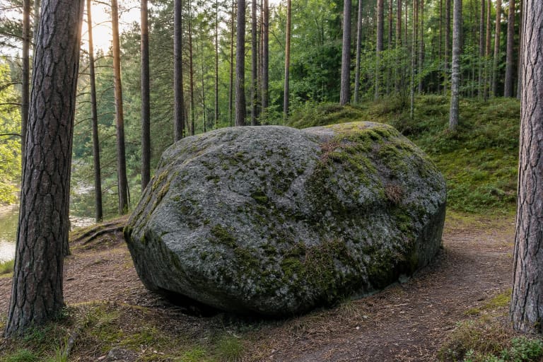
Two sloping faces resemble a mossy cottage roof
VLE gives the visible portion as 4.50 metres long, 3.80 metres wide, and 2.45 metres high, with a maximum horizontal circumference of 13.30 metres. Other published measurements are 4.20, 4.00, 2.67, and 13.51 metres. These differences reflect measurement positions and changing exposure rather than two different stones.
The boulder is an irregular pyramid. One side is steep, while two others slope together like a gabled roof. Older descriptions accordingly compared it with a moss-covered cottage sunk into the ground.
Its surface is uneven, weathered and cracked in places, with much of it covered by moss and lichen. They are living parts of the forest and heritage setting, so never scrape them off, write on the rock, or climb to the top merely for a photograph.
An ice sheet carried rapakivi granite from Fennoscandia
Petrologically, Barbora Boulder is amphibole-biotite granite known as rapakivi. Its structure is granitic, porphyritic, and variably grained, while its texture is massive. Coarse reddish-brown grains and darker biotite and hornblende inclusions show best where moss does not cover the surface.
VLE also provides a mineral composition: about 70 percent microcline, 15 percent quartz, 10 percent plagioclase, up to five percent biotite and hornblende, plus a small amount of apatite. These proportions show that one uniform material does not create its colour and pattern.
The last ice sheet brought the boulder from Fennoscandia into what is now Lithuania and left it in this low forest site as it melted. That is the documented geological origin and must be distinguished from later stories about giants and a devil.
The site is protected for both geology and storytelling
Barbora Boulder has been protected since 1964. The State Service for Protected Areas currently lists it among Anykščiai District's geological natural-heritage objects. Since 2000 it has also held natural and cultural monument status, and the Cultural Heritage Register records it as a state-protected mythological place under unique code 1870.
The dual protection makes sense: geology values the rock, shape, and glacial origin, while culture values the name, narratives, and local memory. Legends alone cannot explain the geology, but a mineral list alone cannot explain why a woodland stone became a named place.
Barbora Boulder lies outside Anykščiai Regional Park, although activity reports mention its care by protected-area staff associated with the park group. Do not therefore assume that every park route or infrastructure promise applies to this remote object.
Three legend traditions are not historical facts
One legend says giants carried the stone and dropped it. Another says a devil intended to destroy a church with it; local retellings often connect that church with nearby Troškūnai. These are folk narratives, not explanations of the glacial erratic's origin.
A further story tells of a landowner's daughter named Barbora who met a poor young man secretly by the rock. After losing him, or after her father forbade their marriage, she supposedly drowned and gave the stone its name. In another local version, a shepherd girl named Barbora drowned nearby.
The versions contradict one another in detail, so they are presented as folklore. It is reliable that the name and narratives belong to local memory; there is no basis for claiming historians have identified a particular Barbora who died here.
The damp lowland rewards proper preparation
The boulder sits on level, damp forest ground. After prolonged rain or spring thaw, soil can become waterlogged and forest-road ruts fill with water. Wear waterproof footwear, carry an offline map, and leave enough daylight for the return.
There are no guaranteed museum hours, lighting, or permanently staffed visitor post in the forest. Official public sources list no compulsory admission ticket, but forestry work, wildfire danger, or a damaged road can alter access. Follow State Forest Enterprise and protected-area signs on site.
With children, choose a short approach only in dry weather. Protect the boulder and setting: do not climb the mossy top, light a fire beside it, drive to the rock, or leave litter.