- Place
- Barklainiai, Daujėnai Eldership, Pasvalys District Municipality
- Region
- Aukštaitija
- Type
- upwelling karst spring and state-protected hydrogeological natural monument
- Address
- Left bank of the Orija, eastern edge of Barklainiai village, Daujėnai Eldership
- Coordinates
- 55.95900, 24.54426
- Visit duration
- 15-30 minutes to see the collecting ring, short mineral-whitened channel, and Orija bank
- Best time
- in daylight and dry weather; the unfrozen spring is interesting in winter, but the bank may be slippery
White Spring, Barklainiai Spring, Berklainiai Spring, Berklainiai White Spring, Orija Spring
The right Barklainiai, and what the pin actually marks
Baltasis Spring lies at the eastern edge of Barklainiai village in Daujėnai Eldership, only a few metres from the left bank of the Orija. The coordinate 55.959000, 24.544263 was converted from the Lithuanian Geological Survey's LKS-94 point 533987, 6202891. It marks the spring's concrete collecting ring, not a car park or road entrance. These are the southern Barklainiai near Daujėnai, not the other village of the same name beside Krinčinas and the Barklainiai manor heritage.
The spelling varies even among official sources. The Geological Survey's address and the current state-protected list use Barklainiai, while its synonym field, VLE, and some municipal records use Berklainiai. Baltasis, Barklainiai, Berklainiai, and Orija Spring all refer to this same source; the coordinate beside the Orija is more dependable than a name-only search.
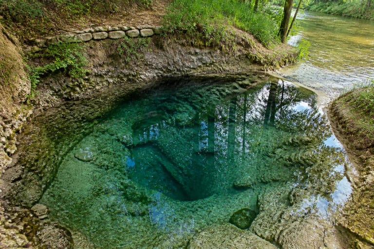
Do not expect a large natural pool. The recognisable feature is a low circular concrete ring on a grassy bank. A dated 2021 VLE photograph shows a short outlet into the Orija, old branch-shaped timber rails, and an unpolished rural setting. This is a very small place whose interest lies in the water, deposits, and immediate relationship with the stream rather than substantial visitor infrastructure.
Clear water, white channel
The Geological Survey classifies Baltasis as a perennial upwelling karst spring. Pressurised water arrives from rocks of the Upper Devonian Tatula Formation beneath roughly 10-15 metres of Quaternary deposits. A peer-reviewed study of Daujėnai geology explains that these karstifying beds contain abundant gypsum together with dolomite and dolomitic marl.
The water itself is clear and colourless. What looks white is the calcium sulphate, or gypsum, precipitated onto pebbles and grass along the outlet. Baltasis, meaning White, therefore records a mineral coating rather than a legend or milky water. Do not scrape, break, or collect the deposits; they form part of the protected hydrogeological feature.
Hydrogen sulphide gives the spring its unmistakable rotten-egg smell. The geological study links its formation to organic matter decomposing without oxygen in the aquifer's recharge area. The smell is a documented natural trait, but it proves neither purity nor curative value.
A road buried the old outlet, but the water found another way
The Geological Survey's local-history record and VLE say that road works serving the Barklainiai field-stone site buried the former outlet around 1977. The spring did not vanish: it broke through below the new embankment close to the Orija. Some later local summaries use 1978, so the defensible account is a road-building episode around 1977-1978, not an exact uncontested year.
Today's outlet is deliberately captured. The Geological Survey describes a concrete chamber about 0.8 metres wide and 0.98 metres deep, followed by a channel almost 3 metres long and roughly 0.4 metres wide into the Orija. Water emerges below made ground near a road culvert, so the visible ring is a capture structure rather than the spring's deepest natural cavity.
Memories of the old flow rising 30-40 centimetres and being visible from a distant hill were recorded from residents as local history. They do not describe the present scene. The Survey's published discharge of 1.53 litres per second places Baltasis among significant springs of moderate flow; it is not a geyser or fountain.
Protected heritage, measured at different moments
Baltasis Spring has been protected since 1985. VLE dates its natural-monument designation to 2000, and the State Service for Protected Areas still lists it among Pasvalys District's hydrogeological natural heritage in an update dated 2025. This is natural heritage, not a property in Lithuania's Cultural Heritage Register.
The sample published in the Geological Survey's site profile measured 7.2 degrees C, pH 7.5, total dissolved minerals of 2.45 grams per litre, sulphate at 1,307 milligrams per litre, calcium at 615 milligrams per litre, and total hardness of 32.91 milliequivalents per litre. Nitrite, nitrate, and ammonium were not detected in that sample. These are results from a particular test, not a guarantee of identical chemistry or microbiological quality on every visit.
The Survey's 2024 monitoring review includes Baltasis in northern Lithuania's natural groundwater anomaly caused by gypsum-bearing rocks. Dissolving gypsum produces calcium-, magnesium-, and sulphate-rich water whose sulphate concentrations exceed the 250 milligrams per litre value applied to drinking water. Good chemical status in an environmental assessment is not the same as safe drinking water.
Folk remedies are not medical advice
Local testimony recorded by A. Linčius in 1990 says that villagers once carried the water home for baths. One resident attributed relief from sciatica to those baths, and a claimed cure for a fungal skin infection was also recorded. These accounts matter as evidence of local custom and belief, but they are not clinical trials or validated treatments.
The Geological Survey's 2024 review explicitly says groundwater with this anomalous chemistry is unsuitable for routine drinking or household use. There is no public water supplier here, no continuously published microbiological certificate, and no guarantee covering the moment when a visitor fills a bottle. Do not taste the water, collect it for drinking, or use it to treat skin or joints.
A safer visit is observational: watch the clear water in the ring, look for pale deposits, and follow the short outflow into the Orija. Do not climb into the chamber, lower your head over the water, handle the deposits, or introduce anything into the spring.
How to visit without overestimating the facilities
The Geological Survey's profile records a direction sign, vehicle approach, concrete steps, and a collecting chamber arranged like a traditional lever well; VLE's 2021 image confirms a simple visitor setting. No later official condition report located by 19 July 2026 verifies every step, rail, sign, or lever. Follow what is actually present and do not assume every item shown in older material survives unchanged.
No separate opening hours, tickets, or booking system are published because this is a small outdoor natural feature. Nor could this research confirm a formal car park, toilet, lighting, or step-free route to the ring. Park only where lawful without blocking the narrow road, keep vehicles out of cultivated fields, and approach in daylight.
The grassy Orija bank can be wet, muddy, or icy. Wear shoes with grip, supervise children beside the open chamber and stream, and do not lean on improvised timber rails. Fifteen to thirty minutes is ample here. For a fuller karst route, continue to Žalsvasis Spring, Pasvalys Sinkhole Park, and Pasvalys Regional Museum.