- Place
- Vilnius City Municipality
- Region
- Vilnius
- Type
- pedestrian and cycle bridge, city viewpoint, and link between public spaces
- Address
- Link between Upės Street and A. Goštauto Street across the Neris, Vilnius
- Coordinates
- 54.69273, 25.27251
- Visit duration
- 20-45 minutes for the bridge; 1.5-3 hours with the right-bank sports grounds and riverfront path
- Best time
- a dry morning or evening from spring to autumn, after checking temporary access restrictions when a major event is scheduled
Baltasis tiltas, Vilniaus Baltasis tiltas
Where the bridge begins and its surroundings end
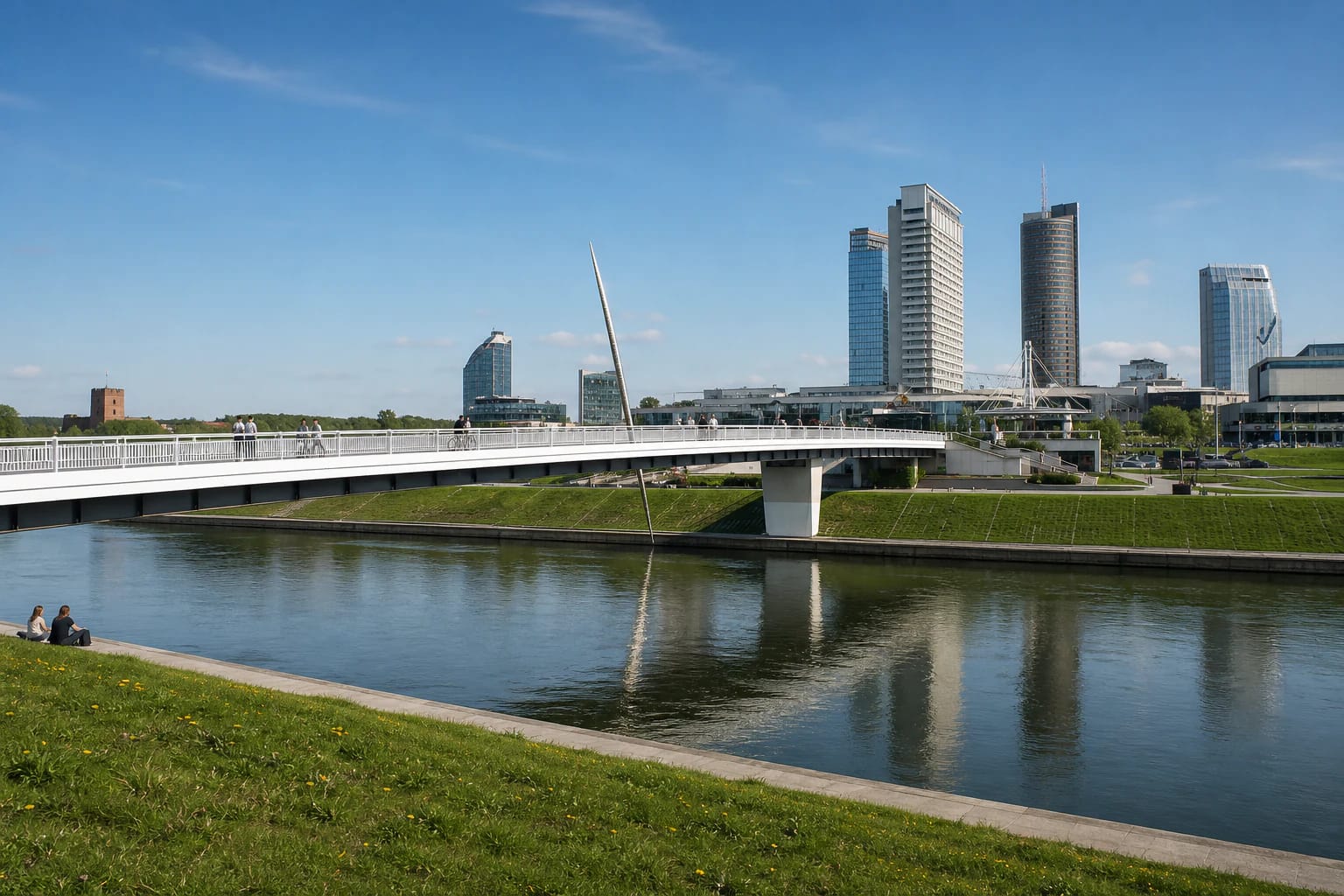
White Bridge crosses the Neris in central Vilnius. Its southern end reaches Naujamiestis near A. Goštauto Street and the axis of Gediminas Avenue, while the northern end arrives in Šnipiškės beside Upės Street. The coordinates 54.6927301, 25.2725099 identify the exact Google Maps listing near the northern section and the sculpture, not a boundary for the bridge's long footprint.
Municipal project material gives the bridge's overall length as approximately 240 metres. It extends much farther than the river channel because early right-bank concepts envisaged an artificial island or peninsula beside the future crossing. The water feature was never created, but the long connection to Upės Street remained. A direct crossing takes roughly 5-10 minutes; allow 20-45 minutes for the views and sculpture.
In everyday speech, White Bridge often means the whole surrounding district, but visitors benefit from separating its parts. The bridge itself is the river crossing. The sports grounds of almost nine hectares, lawn, embankment terraces, and landing stage are distinct spaces on the right bank. CUP is a private shopping centre beyond Upės Street, while Green Bridge is another road bridge with pedestrian pavements located upstream to the east.
A 1995 link within the plan for the right bank
The site of the crossing was not chosen in isolation. Vilnius planning documents show a connection in roughly this position in the 1963 layout for the right bank of the Neris. It was intended to link the older centre with a new commercial and administrative district, making the bridge part of a larger urban composition from the outset.
Project data published in the architectural press record intermittent design work in 1974-1986 and the completion of the first construction phase in October 1995. A Panorama report on 25 October 1995 documented static and dynamic testing with loaded lorries and a column of soldiers. The idea therefore matured over several decades and was finally realised in independent Lithuania.
VLE lists White Bridge among architect Algimantas Nasvytis's major projects and dates it to 1995. The architect's biography published by Vilnius City Municipality adds that the bridge and café were designed with J. Fišeris, identified as Jokūbas Fišeris in a 1996 architectural publication. The crossing is consequently better understood as a designed urban link whose approaches and public uses formed part of a wider concept, rather than anonymous infrastructure.
The familiar name remained an everyday usage for years before receiving formal status. In 2023, the municipality officially named the structure Baltasis tiltas, or White Bridge, under unique number 4400-6065-3683. This does not change the 1995 completion date, but it explains why older documents may use an informal name or simply describe a pedestrian bridge.
Spindulys-ietis: artwork, not a bridge pylon
The bridge's most recognisable marker is Spindulys-ietis, or Ray-Spear, a narrow, slanting stainless-steel sculpture. Installed in 2010, it rises to almost 20 metres. Sculptors Kunotas Vildžiūnas and Martynas Lukošius created it for the Vilnius Signs project marking the twentieth anniversary of Lithuania's restored independence.
The form appears to pierce the deck: a tapering point rises above the bridge while its continuation is visible below the structure. Project descriptions interpret the motif as a sign of breakthrough, national renewal, courage, and the struggle for independence; the spear was also associated with the attribute of St George. That is the project's symbolic reading, not a description of the bridge's engineering function.
The striking detail can be misleading in photographs. Ray-Spear does not support the bridge and is not a cable pylon. White Bridge is a low girder pedestrian structure, with the sculpture attached as an independent work of contemporary art. The relationship is easiest to read from the riverbank or from a point some distance away on the deck.
White Bridge sports grounds, lawn, and events
On the northern right bank, the municipality opened a refurbished sports and recreation area of almost nine hectares in 2020. It contains nine beach-volleyball courts, three double-sided basketball courts, children's play areas, outdoor calisthenics and exercise equipment, and a skate and roller park. The largest volleyball court was prepared for international competition, while the basketball courts held FIBA certification when the complex opened.
Differences in level were used to create small amphitheatres and seating terraces, with ramps and intermediate landings descending towards the lower embankment. A large lawn remains available for picnics and events. Concert stages, festival fences, food trucks, and temporary sports installations appear only for specific programmes and should not be mistaken for permanent bridge infrastructure.
The grounds and lawn are normally free to enter, although a particular court may be occupied by training, competition, or maintenance. Nearby food businesses and CUP set their own opening hours and prices. If the purpose of the visit is a particular restaurant, event, or court booking, check the relevant operator's official information before travelling.
Free access, shared movement, and 2026 practical details
White Bridge itself has no gate or admission ticket. On 21 July 2026, its exact Google Maps listing marked it as open 24 hours, although a major event, cleaning work, ice, or another temporary safety measure may alter normal movement. The surface and long sloping approaches allow the river to be crossed without compulsory steps, but the deck can become slippery in wet or cold weather.
Pedestrians, cyclists, and other micromobility users share the deck. Vilnius City Municipality has noted that growing flows mix at the bridge ends, so cyclists should reduce speed and pedestrians should keep a predictable line. Ramps descending to the right-bank lower terrace belong to the surrounding embankment rather than the bridge deck itself.
During the warmer season, the JUDU Neris route includes a White Bridge stop for electric boats. Timetables, operating season, and fares change, so check the official JUDU page on the day of travel. On 21 July 2026, the exact Google Maps listing showed 4.7 out of 5 from 5,173 reviews; Place ID ChIJ3f1acQaU3UYRKuXvTnKVTVc helps distinguish it from listings for food venues or the sports complex.