- Place
- Netoniai, Kaunas District Municipality
- Region
- Kaunas District
- Type
- officially listed landscape viewpoint and active hang-gliding and paragliding launch site
- Address
- 63 Skrydžio Street, Netoniai, Kaunas district
- Coordinates
- 54.94047, 23.72196
- Visit duration
- 45-90 minutes; longer when combined with the cycle route along the right bank of the Nemunas
- Best time
- a clear, dry day from spring to autumn; evening for light over the Nemunas, but never during a thunderstorm or dangerously strong wind
Netonių kalva, Netonių kalnas, Sklandytojų kalva, Gliders' Hill
A 55-metre hill above the Nemunas valley
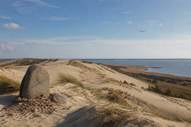
Netoniai Hill rises on the right bank of the Nemunas in the village of Netoniai. The Kaunas District Tourism Centre gives its height as 55 metres. From the open field at the top, visitors see the river, green valley slopes, broad woodland, and Kačerginė on the opposite bank. The figure describes the hill itself and should not be presented as an elevation above sea level.
Lithuania's Ministry of Environment includes the Netoniai site in its list of the country's most valuable landscape panorama viewpoints under the name Gliders' Hill. On a clear day, the view unfolds in distinct layers: a steep green slope in the foreground, the curving Nemunas below, then the wooded left bank and the roofs of Kačerginė. Summer foliage can hide part of the lower valley, while rain or mist sharply reduces visibility.
A landscape viewpoint that is still an active flying site
There is no formal urban viewing promenade with continuous railings. The core of the site is an open grass flying field that doubles as a viewpoint. The official photograph shows carved wooden benches shaped like wings or flying craft and a small metal platform. A memorial stone marks the most important event in the site's aviation history.
The official page does not publish the metal platform's current structural condition or rules for visitor use. The panorama is fully visible from the ground, so climb only if signs on site clearly say that the structure is open and safe. The edge of the slope is steep, and grass and exposed soil may be slippery after rain.
The Lithuanian Hang Gliding and Paragliding Sport Federation lists the Netoniai flying site among the locations used by the Kaunas club Skrydis kartu. When pilots are preparing, visitors share a working sports space. Do not stand in front of an inflated wing, cross the launch or landing line, touch equipment, or fly a kite or drone, and keep dogs on a short lead. Flights depend on wind, weather, and pilots' decisions, so there may be no flying activity during a visit.
The interwar gliding base and the 1952 revival
According to the Kaunas District Tourism Centre, the southern Nemunas slope at Netoniai served as one of Lithuania's principal gliding bases during the interwar period. B. Oškinis, J. Balčiūnas, V. Dovidaitis, V. Drupas, T. Karonkevičius, and other pilots flew on the Netoniai and Virbaliūnai slopes.
Flying around Kaunas continued during the Second World War using craft designed by Bronius Oškinis, and the official account marks 1952 as the beginning of a gliding revival here. The Lithuanian Aviation Museum describes Oškinis as one of the country's foremost gliding pioneers and highlights his T-1 design, tested in 1932. This broader story explains how an apparently simple river slope became a place of technical and sporting heritage.
The 1977 competition and Alfonsas Liekis's record
The Kaunas District Tourism Centre and a memorial stone by sculptor Stasys Žirgulis, unveiled in 2017, both state that Lithuania's first hang-gliding competition took place at this spot in Netoniai in May 1977. VLE's general history of the sport names Kulautuva as the competition location, so the sources differ in their precise place name. This page follows the wording of the local memorial and official attraction listing while making that discrepancy explicit.
Another precisely dated achievement followed on 23 May 1981. In difficult conditions, Alfonsas Liekis remained aloft for 37 minutes and 56 seconds; on another flight he travelled from Netoniai to Raudondvaris and returned. These episodes explain why the site is known both as Netoniai Hill and Gliders' Hill.
Arriving via Skrydžio Street and planning a visit
The official address is 63 Skrydžio Street, Netoniai. Coordinates 54.940465, 23.721955, converted from the LKS-94 point in the official e-TAR list, mark the viewpoint itself. Drivers should follow local signs because the official attraction page does not describe a dedicated car park. Keep to visibly used access, signs, and fences; do not cross adjoining fields, block residential driveways, drive or park on grass, or enter the flying area.
Allow 45-90 minutes for the view, memorial stone, and benches. Cyclists can extend the outing along the right bank of the Nemunas towards Kulautuva. No official source documents a uniformly surfaced, step-free route to the viewpoint, so uneven grass, gradients, and the steep unguarded edge may create barriers for wheelchair users and visitors with limited mobility.
As of 29 July 2026, the official tourism page listed no separate admission charge, fixed opening hours for the hill, public toilet, drinking water, or food outlet. Office hours shown elsewhere on the tourism website are not operating hours for Netoniai Hill. This is not a flight-booking desk; anyone wishing to fly must make separate arrangements with a lawful operator and follow that operator's safety and weather requirements.