- Place
- Visaginas Municipality
- Region
- Aukštaitija
- Type
- Glacial lake beside the city with a 400-metre public sandy beach, designated bathing water, and forested shores
- Address
- 16B Parko Street, Visaginas (municipal beach)
- Coordinates
- 55.59500, 26.42890
- Visit duration
- 1-3 hours for the beach and shore paths; half a day with a Visaginas architecture route
- Best time
- June-September for swimming after checking the latest water test, or spring and autumn for a quiet forest and shore walk
Visagino ežeras, Visaginas Lake, Visaginas city lake
The page pin marks the municipal beach, not the centre of the lake
Lake Visaginas lies immediately south of the city, with its principal visitor access on the north-eastern shore at 16B Parko Street. The coordinates 55.5950, 26.4289 are the Hygiene Institute's official bathing-water monitoring point. This is an intentionally representative pin for the managed beach, not the centre of the broad lake and not a promise of parking at the water's edge.
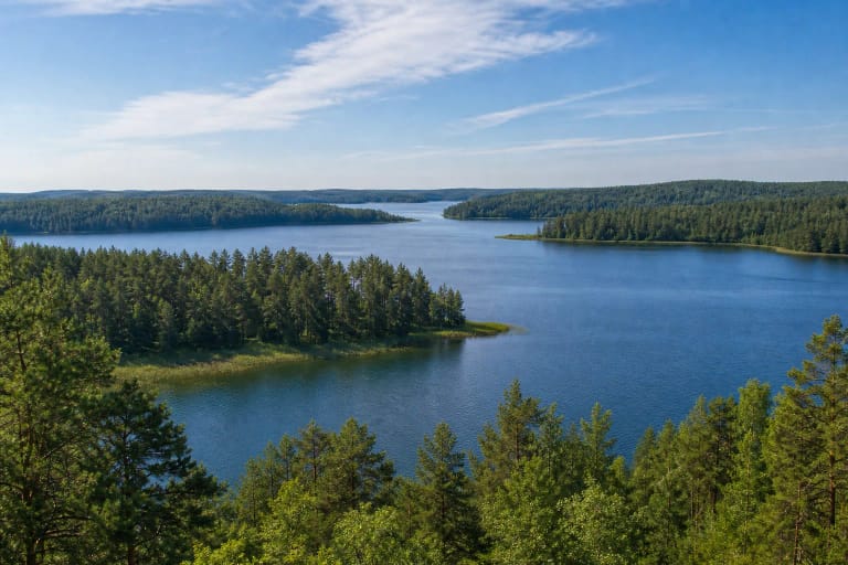
The lake covers 220.4 hectares, stretches 2.3 km from north-west to south-east, and reaches 1.6 km at its widest. Maximum depth is 6.5 m and average depth 2.9 m, while the surface lies about 149.5 m above sea level. It is relatively shallow, but those whole-lake figures say nothing about the precise conditions at any chosen entry point.
Its shoreline winds for 8.1 km, yet most banks are low, wooded, and marshy. The drier north-eastern shore is where the municipal recreation area developed. A walk around the lake should therefore not be understood as a continuous 8.1-kilometre paved circuit.
A glacial hollow holds two islands, reed beds, and a water connection towards Drūkšiai
The lake occupies a hollow left by a buried block of glacial ice. Material published by Visaginas City Museum in 2026 estimates its geological age at approximately 16,400 years. This is a natural water body vastly older than the twentieth-century city and its recreational waterfront.
Two small islands cover about 0.5 hectares in total. The Paklevė and another stream enter the lake; the Visaginas stream flows out and reaches Lake Drūkšiai through the Gulbinė. The whole system belongs to the Daugava basin, but Lake Visaginas is not Lake Drūkšiai, the separate water body beside the Ignalina Nuclear Power Plant.
Sand and peat alternate in the littoral zone, with sapropel in deeper water. Reeds, bulrushes, and horsetails fill sheltered bays. The official beach profile notes that the recreational shore silts up and repeatedly develops reeds that have to be removed, explaining why the managed bathing area is a better choice than an improvised approach through marshy ground.
The lake name has a five-century written record and returned to the city in 1992
Visaginas City Museum traces the first known written record of the lake name to a 1526 act issued by Albertas Goštautas. While endowing the church at Daugėliškis, the nobleman donated Lake Visaginas to it. This is documented history of the hydronym rather than a story invented with the nuclear city.
A village called Visaginas, written Wisaginia in historical sources, once stood on the northern shore. According to the museum, seven houses and thirty residents remained there in 1938. Construction of a settlement for the Ignalina Nuclear Power Plant workforce began beside the lake in 1975; from 1977 until 1992 it was called Sniečkus.
The town officially received the present name Visaginas on 22 September 1992, reconnecting a new city with an older place-name. Linguistic explanations treat the hydronym as Baltic and connect it with the name of a small incoming stream. The popular explanation that it derives from the Lithuanian phrase visi ginasi is best understood as later wordplay, not proven etymology.
The 400-metre public beach concentrates swimming, sport, and family recreation
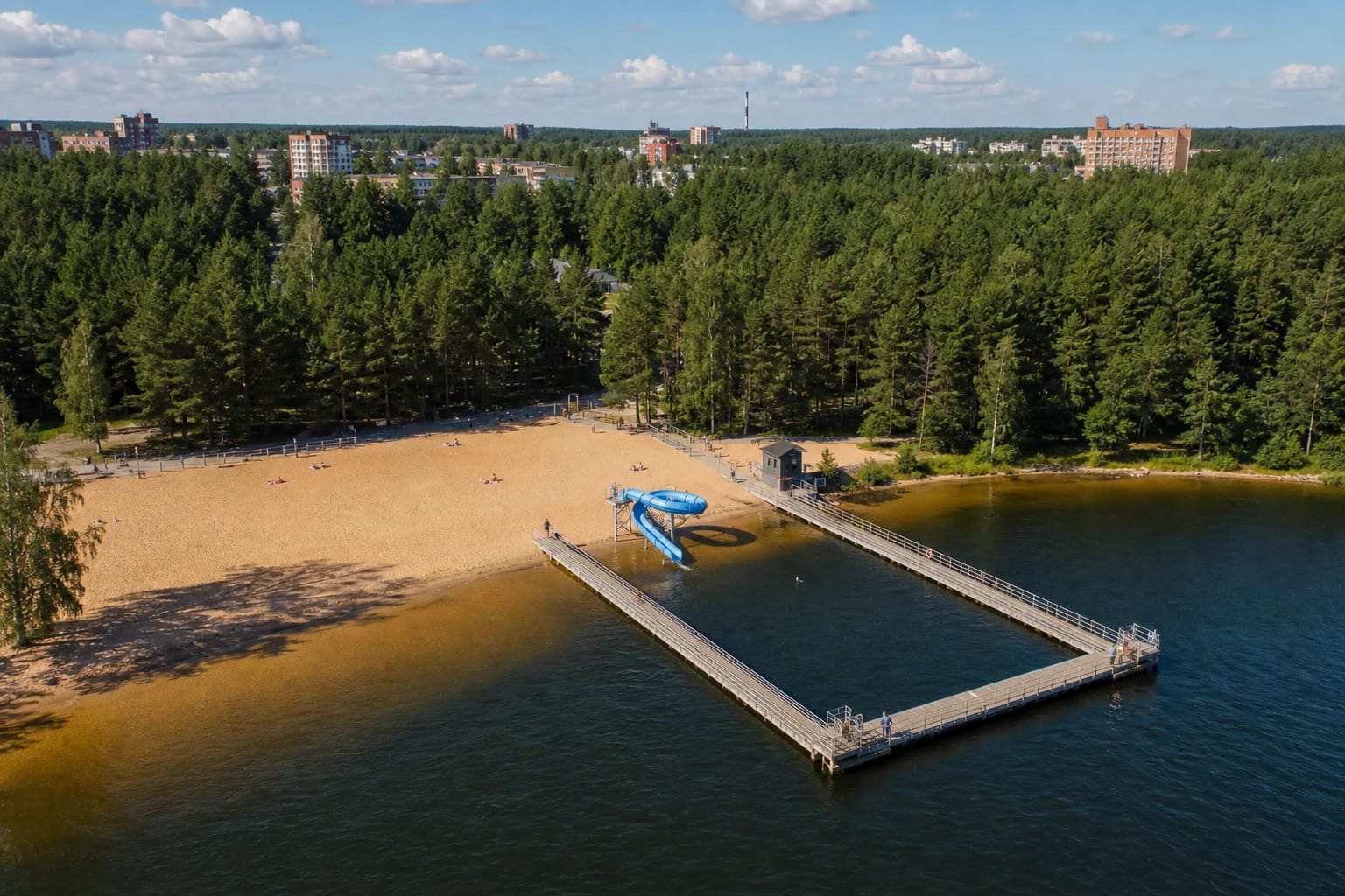
The Hygiene Institute's 2024 profile identifies the beach as public and approximately 400 m long. It recorded a general swimming zone, children's bathing area, rescue point with first-aid equipment, play facilities, beach volleyball and basketball courts, and walking and cycling paths. Estimated peak use in the best summer weather was about 400 visitors.
Its most recognisable structure is the pontoon system forming a rectangular bathing enclosure, accompanied by a blue water slide. The pontoons, jetty, and slide structure underwent repair in 2024-2025; work ran late in 2025 and completion was announced later. Slide operation, lighting, and access to individual pontoon sections remain seasonal, so check locally before travelling solely for them.
The 2024 profile also recorded a toilet and seasonal waste-sorting facilities. The beach has no general gate or admission ticket, but food, equipment hire, camping, and other nearby services may charge and keep separate hours. A rescue point does not mean that a lifeguard is present every day or around the clock.
Water quality was classified excellent, but every swim still needs the latest result
The 2024 Hygiene Institute profile states that bathing-water quality met the excellent standard throughout 2018-2024, while the lake's ecological status was assessed as good. This is a multi-year classification rather than a guarantee for a particular day in 2026. Heavy rain can cause short-term contamination from surface runoff, so consult the municipality's latest sample or the noticeboard before swimming.
The official profile gives an average depth of roughly 2 m and a maximum of about 3 m within the bathing water. These figures do not define a safe depth for every visitor: supervise children, jump from pontoons only where expressly permitted, and remember that bottom conditions can change after storms or shifts in water level.
Animals are prohibited on the managed beach. Official water-quality notices also ask visitors not to bathe pets outside designated places, wash vehicles, use soap or shampoo in the water, litter, or feed birds. Other shores may have separate land-use rules, but they should not be treated as unrestricted substitutes for the beach.
Accessibility has been improved, while a complete circular trail should not yet be assumed
In 2023 the municipality commissioned a two-metre-wide hardwood route to the shore, two accessible rest areas, an adapted changing cabin with shower, and a handrail into the water. A 2024 notice still described a bathing device that lifeguards were expected to help operate. Because these publications documented works and plans rather than a current end-to-end audit, confirm the device, assistance hours, and actual route before visiting.
In 2025 the municipal council approved a broader proposal to improve beach approach and parking, mark a route around Lake Visaginas, and connect it with the Kukuižė bog and Gražutė Regional Park. Project documentation was still part of that decision, so it cannot be presented as proof of an already completed circular trail. Follow the signs on the ground and do not cross wetlands simply because a map shows the shore continuing.
Allow 1-3 hours for the beach and a short shore walk, or add Visaginas's apartment districts and city museum for a half-day route. The contrast is clearest from the sand: pontoons and a natural lake in front, pines immediately behind, and the planned city's blocks above the trees. Treat Lake Drūkšiai and the nuclear plant as a separate excursion.