- Place
- Kupiškis District Municipality
- Region
- Aukštaitija
- Type
- nationally significant KVR complex comprising a hillfort and settlement, with a surviving outer ring rampart and ditch
- Address
- Piliakalnio Street, Kupiškis, Kupiškis district
- Coordinates
- 55.84787, 24.97550
- Visit duration
- 30-60 minutes for the summit, earthwork ring, and views; longer if continuing along the Kupiškis Reservoir shore
- Best time
- in daylight and dry weather; during the 2026-2029 project, check current construction and access conditions before setting out
Kupiškis Hillfort, Aukštupėnai Hillfort
KVR protects a hillfort and settlement complex, not only the mound
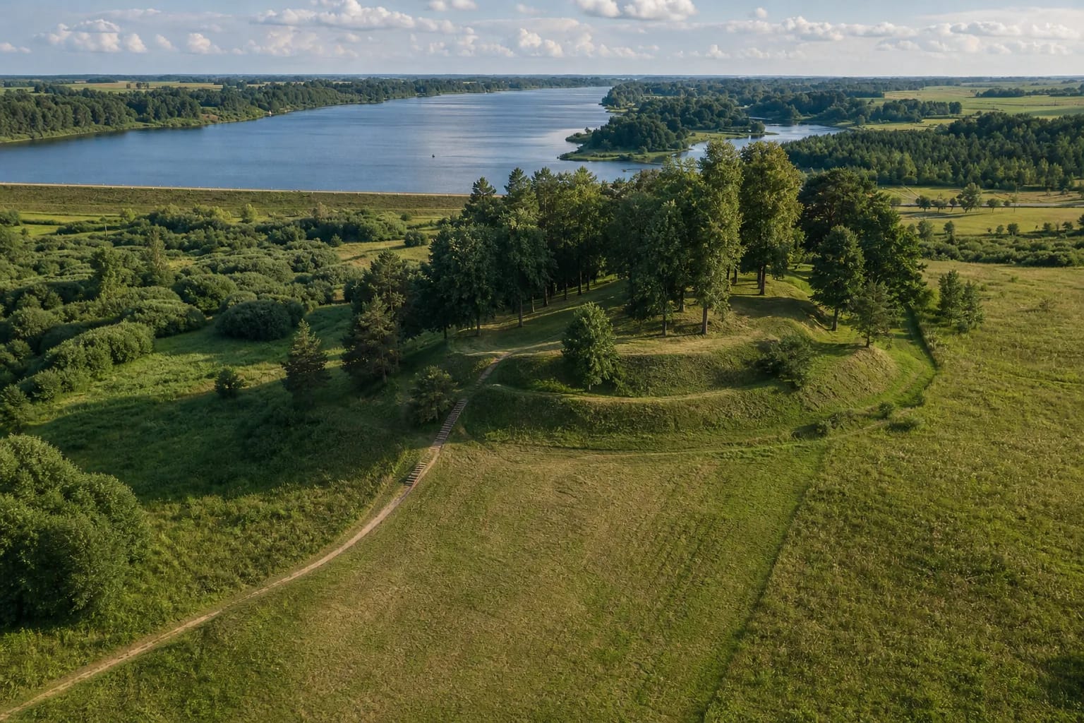
Kupiškis (Aukštupėnai) Hillfort rises on the northern edge of Kupiškis, on the left bank of the Lėvuo beside the Aukštupis valley. The coordinate 55.847871, 24.975505 is the KVR representative centre point for the broad hillfort component. It is not an entrance, the foot of the stairs, or a parking location.
KVR registers the property as the Kupiškis and Aukštupėnai hillfort complex with settlement under unique code 23819. Its independently registered components are hillfort 5273 and foot settlement 23820; all three records have monument status and national significance. The defined complex covers 85,848 square metres, while the protection buffers extend beyond the silhouette that a visitor recognises as the hill.
Most of the complex is associated with the Kupiškis municipal boundary, while the northern and eastern parts of its protection zone extend into Aukštupėnai village. Nearby Kupiškis Reservoir and Uošvės Liežuvis island are useful landmarks but not parts of the hillfort. Their recreation grounds, bridges, paths, and facilities cannot automatically be treated as hillfort amenities.
A 110 by 40 metre summit sits inside two differently understood defensive layers
The elongated north-south summit measures roughly 110 by 40 metres and covers about 4,400 square metres. Aukštupis encloses the hill to the north, the Lėvuo valley lies to the west, and marshy hollows lie to the east; only the southern side joins the neighbouring upland. Its moderately steep slopes rise between 8 and 20 metres.
About 4-4.5 metres below the summit edge runs a visible outer rampart ring approximately 280 metres long, up to 1.8 metres high and 7 metres wide. On the north-western, northern, eastern, and southern sides it is accompanied by a ditch up to 3-4 metres wide and 2 metres deep; on the western slope the rampart survives as a terrace. One caveat is essential: this outer system has not been excavated, so its construction date is still unknown.
The present relief is not an untouched prehistoric shape. The summit was ploughed for years, trenches and pits were dug during the First World War, and the surface was later levelled and planted with trees. The 2017-2018 work showed that cultural deposits had been scraped from the centre and moved to the edges, where they concealed an older internal rampart about two metres high.
One small trench revealed four phases of strengthening and fire
In 2017 researchers placed 150 boreholes across the summit and combined ground-penetrating radar, magnetometry, and soil geochemistry. In 2018 they excavated one 20-square-metre trench on the eastern edge and obtained 12 AMS radiocarbon samples. The mixed methods transformed understanding of the site, but the excavated area was only a small fraction of the 8.6-hectare complex.
The earliest dated defences belong to the eighth to fifth centuries BC. A wooden barrier stood on the summit edge, supported by a surviving bank of fieldstones and sandy soil about 0.5-0.6 metres high. After it burned, the bank was reinforced with more cohesive soil and oak and birch timbers, then rebuilt quickly on at least several occasions.
A later fire horizon dates to the fifth to sixth centuries AD, while the last renewal and destruction of the excavated internal rampart falls in the eighth to tenth centuries, with 779-988 AD the most likely combined interval. No secure traces from the start of the second millennium were found in the trench. That limits medieval claims but does not prove that the entire foot settlement or the unexcavated outer ring went unused at the time.
Pottery, barley, and animal bones say more than the later coins
The investigations registered about 230 finds, most of them pottery. Of 219 fully catalogued sherds, brushed pottery was the largest group, accompanied by smooth, fine-grained, burnished, rough-surfaced, and other wares. This mixture points to activity in more than one short episode rather than a single occupation event.
One barley grain was dated to 755-413 BC, while a possible lentil fragment was identified cautiously. Animal bones represented cattle, sheep or goats, pigs, a horse, and deer, and one fragment of iron slag was also recovered. The small sample cannot establish a population total, reconstruct the entire economy, or show exactly how long people lived on the summit.
Two early seventeenth-century Riga coins, a sandstone whetstone, a few pieces of wheel-thrown pottery, and modern objects came from upper deposits disturbed at a later date. They show that the hill continued to be visited as the town and nearby manor developed, but they do not demonstrate unbroken settlement from prehistory into the modern period.
The thirteenth-century castle and a southern Selonian centre remain hypotheses
Popular accounts repeat that a Selonian timber castle stood here and that the Sword Brethren destroyed it around 1240. The excavation report stresses that the origin of this claim is difficult to trace, no chronicle names such a castle, and the 2018 trench produced no prehistoric evidence later than the eighth to tenth centuries. A specific destruction in about 1240 is therefore an interpretation, not an established event.
Before excavation, researchers had also considered the hillfort a possible political centre of southern Selonia or a centre of the historical lands named Medenė and Pelonė in written sources. These are proposed geographical identifications, not conclusions supported by an inscription or a securely dated ruler's residence. The excavator found that early second-millennium evidence was still insufficient to assess such a role.
Caution works both ways. A single 20-square-metre trench cannot disprove the history of a large settlement, while a rampart-and-ditch ring that looks medieval cannot by itself prove a castle. A firmer answer depends on future work in the unexcavated outer defences and the foot settlement.
Existing stairs do not create step-free access, and the new works are unfinished
KVR's 2023 record says the hillfort has been adapted for visiting and has installed stairs. Large height differences, grassy slopes, earth paths, and steps nevertheless mean that the summit should not be described as barrier-free. The municipality's own project description calls the present setting inadequately suited to universal-design access.
The municipality is implementing a hillfort visitor-access project from 9 February 2026 to 31 August 2029. At Aukštupėnai it plans a car park, public toilet, paths, wooden footbridge, ramp, steps, lighting, street furniture, and renewal of Piliakalnio Street. As of 19 July 2026, no official notice was found saying that all of those facilities were complete or setting a blanket closure, so check the latest municipal information before travelling.
More open parts of the summit look towards Kupiškis Reservoir, the Lėvuo valley, and Kupiškis, although foliage can screen portions of the view in summer. Leave a car only in a currently signed and permitted place, and never drive over the earthworks or summit even if an old photograph shows a vehicle on the grass. The official sources checked do not provide a dependable list of permanent hours, admission arrangements, or a currently operating toilet.