- Place
- Jogaudai, Plungė District Municipality
- Region
- Samogitia
- Type
- 5 m timber observation tower in Žemaitija National Park beside the former Jogaudai gravel quarry
- Address
- Uošnos Street, Jogaudai, Paukštakiai Eldership, Plungė District
- Coordinates
- 55.99956, 21.94419
- Visit duration
- 30-45 minutes for the tower and quarry view; 60-90 minutes for unhurried birdwatching
- Best time
- a dry day in daylight; early spring or late autumn for a more open view through deciduous trees, and a calm spring morning for birds
Jogaudai Viewing Platform, Jogaudai Lookout, Jogaudų apžvalgos bokštas
A five-metre tower whose quarry-rim setting supplies most of the height
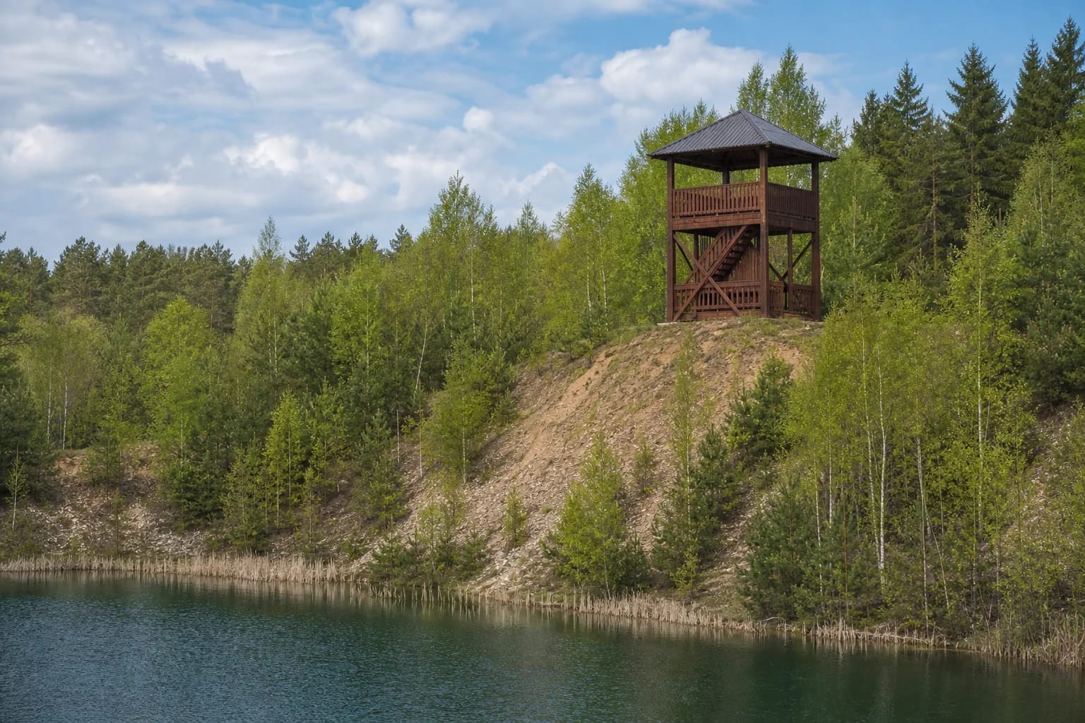
Official sources call the same structure Jogaudai Viewing Platform, Observation Tower, and small lookout tower. The word platform does not mean that the tower has been removed or replaced by a flat terrace. Photographs on the Directorate's current page show a compact dark-brown timber structure with stairs, a square upper deck, vertical-slat railings, and a broad four-sided sheet-metal roof.
The Park Directorate groups the Jogaudai structure with its 5 m timber lookouts. That is much lower than many Lithuanian observation towers, but the structure occupies a pronounced rim above the former quarry. Much of its elevation over the water and young trees comes from the landform rather than from the tower alone.
The official coordinates, 55.999558, 21.944188, mark the tower itself. They are not a separate parking pin, a trailhead, or the centre of the whole quarry. Use them to navigate towards the attraction, then follow local roads and signs for the final approach.
A hill of almost 162 m became a quarry and a pond of nearly 2 ha
According to Žemaitija National Park Directorate, a hill reaching almost 162 m extended south of today's lookout in the 1970s. It was later excavated when a gravel quarry opened. This is a documented transformation of the terrain, not a legend about a sunken hill or a naturally formed lake.
The quarry ceased operating in 2003. At the park's initiative, a government decision recognised the area as especially valuable for recreation, and a water body of almost 2 ha remained where the hill had been removed. Its surface lies about 140 m above sea level. That figure should not be confused with either the tower's height or the elevation of today's rim.
Birches, pines, and other pioneer growth now occupy the quarry margins. A single view therefore reveals three layers: the cut landform, a water-filled depression left by extraction, and vegetation reclaiming the site. No reliable construction date for the lookout was found, so its age should not be guessed from appearance alone.
What you can actually see from Jogaudai Tower
The clearest view looks down over the blue-green quarry pond, its reed fringe, steep sandy banks, and young woodland. Farther away are pieces of Samogitia's rolling relief and scattered homesteads. A fragment of Lake Luoka may appear through the trees to the east, but its visibility varies with foliage, weather, and continued forest growth.
A 5 m lookout does not rise above every surrounding tree. Canopies increasingly screen the northern side and part of the eastern view, so visitors should not expect a fully open 360-degree horizon. In early spring or late autumn, when deciduous trees are bare, the layers of the landscape are easier to distinguish than in dense summer foliage.
Binoculars are useful for birds as well as distant landscape details. Park specialists mention common buzzards, white-tailed eagles, western marsh harriers, and mute and whooper swans flying between local waters. A Eurasian bittern may be heard from the direction of Lake Luoka. These are possible sightings and sounds, not a promise for every visit.
What 2026 sources say about access, maintenance, and repairs
On 20 July 2026, Jogaudai Platform remained listed in both the current Saugoma.lt catalogue and the park's official visitor page, which provides directions. The Directorate's 2026 activity plan includes Jogaudai among six observation structures scheduled for year-round care, including mowing, litter collection, and maintenance of infrastructure elements.
An activity plan confirms intended routine care, but it is not a same-day structural inspection. No separate official notice announcing closure, reconstruction, or major repairs was found by the review date. That finding cannot rule out a temporary restriction after a storm, vandalism, or maintenance work.
On arrival, check barriers, notices, and the visible condition of the timber structure before climbing. Stay off if steps, boards, or railings appear damaged, and follow any occupancy limit displayed on site. Rain, frost, and snow can make the wood slippery, while wind is more exposed on the quarry rim.
Driving, the small stopping area, and the final walk
Jogaudai is approached from road 164, then by local village roads towards Uošnos Street. Route descriptions mention a small stopping or parking area followed by an uphill walk of roughly 100 m to the lookout. The official attraction page does not publish a separate parking coordinate, number of spaces, surface type, or coach turning area, so do not expect a large formal car park.
Enter the official tower coordinates in navigation, then slow down and look for local signs as you approach. Leave a car only where current signs permit and where it will not obstruct the narrow road, a woodland entrance, or access to homes. After heavy rain, the ground and short approach path may be soft or slippery.
The upper deck is reached only by timber stairs, so the tower itself is not step-free or wheelchair accessible. Keep young children beside you, and do not allow climbing on railings or running on the stairs. The open water and steep quarry banks are not safe places for shortcuts.
Planning a short but worthwhile stop
Allow 30-45 minutes for the tower, view, and short walk. If you bring binoculars and wait quietly for birds, 60-90 minutes is more realistic. Because trees screen part of the horizon, seasonal foliage and patient observation matter here at least as much as perfectly clear long-distance visibility.
The official Jogaudai attraction pages do not publish separate opening hours, a ticket office, or compulsory admission. That is not a guarantee of round-the-clock access. Žemaitija National Park offers a voluntary visitor ticket that supports site maintenance; check the Directorate's official page for current prices and purchase terms because they can change.
The official attraction description does not identify the quarry pond as a supervised beach or bathing site, so tower access should not be read as permission to swim. Bring shoes with good grip, binoculars, and drinking water. For a longer day, combine Jogaudai with Paplatelė Nature Trail, Lake Plateliai, Plateliai Manor Park, or Siberijos Observation Tower.