- Place
- Panevėžys City Municipality
- Region
- Aukštaitija
- Type
- Nevėžis reservoir waterfront route with walking, cycling, and recreation infrastructure
- Address
- J. Biliūno Street and Pajuostės Avenue side, Panevėžys
- Coordinates
- 55.73249, 24.38649
- Visit duration
- 1-2 hours for the main terrace and several recreation areas; 2.5-4 hours for a longer out-and-back walk
- Best time
- May-September for the waterfront and outdoor recreation; swim only after checking the latest water-quality notice
Ekrano marios, Nevėžis River reservoir, Panevėžys Reservoir, Ekranas Pond
The attraction is a long public waterfront, while the map pin marks its most recognisable terrace
‘Ekranas’ Reservoir Shore is not a single lookout or merely a beach. The developed public space runs along the J. Biliūno Street and Pajuostės Avenue side, combining an asphalt walking and cycling path with timber approaches to the water, terraces, sports courts, and quieter rest areas. Official city visitor publications commonly describe about 4 km of improved shoreline, although the distance you actually walk depends on your chosen starting point and side routes.
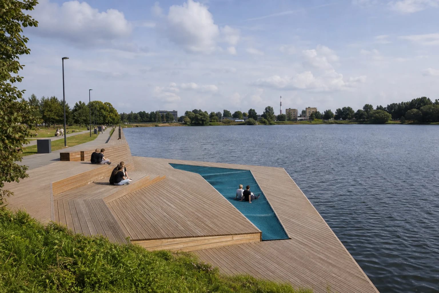
The pin on this page, 55.732489, 24.386489, marks a representative visitor point at the distinctive Ekranas waterfront terrace rather than the center of the entire reservoir. It is best planned as a linear route: choose several areas and return along the same path, or arrange a different exit in advance. On a first visit, begin at the terrace and follow the on-site signs towards the boat launch, sports, or children's areas along the J. Biliūno Street corridor.
The path also functions as a city connection. The project renewed part of the J. Biliūno Street pavement, lighting and a bus-stop surface on Pajuostės Avenue, added parking spaces, and linked the route towards Skaistakalnis Park. Events and seasonal maintenance can temporarily restrict individual areas.
The reservoir was built for industry but became a city recreation area from 1980
The historical record compiled by Panevėžys County Gabrielė Petkevičaitė-Bitė Public Library states that construction of the largest Nevėžis dam began in 1976. The dam and bridge were completed in 1979, and the structure officially opened in 1980. It created an 84 ha reservoir with a maximum depth of 6 m and a volume of approximately 1.9 million cubic metres.
Its main purpose was to supply process water to industries in the northeastern part of Panevėžys, especially the nearby Ekranas cathode-ray-tube factory. The name most residents use derives from that plant, although the water body was also called Panevėžys Reservoir. In the Soviet-era construction account preserved by the library, the unusual urban hydraulic scheme was formally presented as a fire-protection pond.
The flooded area had been mostly scrub-covered land rather than a residential quarter. A beach was created beside the new reservoir from the outset, so leisure is not an entirely recent use. What changed is its scale: a reserve of industrial water became a continuously developed municipal waterfront.
A 2.5 m path connects 11 different recreation and activity areas
The municipal project replaced the old route with a 2.5 m asphalt path shared by walkers and cyclists. It provides access to 11 recreation areas, including picnic and fire sites, beach volleyball, children's play equipment, outdoor fitness, disc golf, benches, and timber paths with pontoon sections leading towards the water. The activities are distributed rather than concentrated in a single plaza, so the waterfront makes most sense as a moving visit.
Its architectural signature is an angular timber terrace projecting over the reservoir. A blue net lounging strip is set into the deck, while stepped timber surfaces offer seats at several levels. Smaller platforms, bridges, and viewpoints appear elsewhere. This is a deliberately designed urban recreation landscape, not an undeveloped wild shore.
Water access includes a launch for small boats, a pontoon point for putting in and taking out kayaks, and a place for short-term mooring. The structures do not guarantee that kayak, paddleboard, or other equipment rental is operating on any particular day. Confirm availability, opening hours, and prices directly with the relevant private operator.
The official beach is only one part of the shore, and every water test applies to a specific date
Panevėžys maintains an official city beach at the Nevėžis River reservoir. For the 2026 season, the municipality listed changing cabins, information boards, toilets, waste containers, and a buoyed bathing zone. Official maintenance was planned from early June through August 31, with water sampled every two weeks and sand tested once a month.
In the latest result published on July 13, 2026, the official reservoir beach had clear water, compliant microbiological indicators, and clean sand. That is not a permanent guarantee for the entire season. Heavy rain, heat, or a later sampling cycle can change conditions, so read the newest municipality notice and the board at the beach before entering the water.
The full waterfront is not one uniformly supervised bathing area. In 2026 the municipality monitored the official beach and several other popular swimming points around the reservoir separately. Swim only in a clearly marked area, do not jump from leisure terraces or pontoon paths, and never treat an attractive water access point as proof of an approved bathing zone.
Do not confuse the completed J. Biliūno-side waterfront with the northern shore still being designed
The established visitor infrastructure was delivered in stages. Connection and access works around J. Biliūno Street were completed in September 2020, the main paths and recreation areas in May 2021, and the overall project record was formally marked complete on March 15, 2024. Dates such as 2020 or 2021 in older descriptions identify particular phases rather than one opening date for everything.
The northern side near Elektronikos Street was in a different position. On May 29, 2026, the municipality said the documentation for its new recreation area remained at the design-proposal stage. The sandy beach, new bathing zone, terrace, pontoons, sports and play areas, showers, and lifeguard rooms described there were future works, not services already available to visitors.
Base a current visit on the completed J. Biliūno Street and Pajuostės Avenue side. Check the northern bank separately, because construction boundaries, vehicle access, and the ability to approach the water can change until that project is finished.
The public space is free, but access and safety vary between sections and seasons
The municipal waterfront project lists no ticket office, admission charge, or gated opening hours. The path and public recreation areas are free to visit, preferably in daylight. A private activity or event may charge separately, but that is not an admission fee for the shore itself.
The 2.5 m main asphalt path, graded approaches, and parts of the developed waterfront support easier movement, but pontoon paths, timber branches, slopes, and temporarily repaired surfaces are not uniform. No recent audit confirming complete access to every area was found, so a wheelchair user should choose a specific entrance and a shorter route in advance.
In winter, reservoir ice must never be assumed safe. In 2026 the municipality installed warnings at Ekranas Reservoir and stressed that snow and fluctuating temperatures can conceal thin sections and open water. In warm weather, supervise children at unguarded edges and cycle at a speed that leaves room for pedestrians on the shared path.