- Place
- Upytė Eldership, Panevėžys District Municipality
- Region
- Panevėžys District
- Type
- a large artificial irrigation reservoir with a dam and a bridge over the Upytė
- Address
- Near Stepanioniai village, Upytė Eldership, Panevėžys District
- Coordinates
- 55.61206, 24.23912
- Visit duration
- 20-45 minutes for a shore view; allow longer for fishing or a quiet stay
- Best time
- a calm morning or evening from late spring to early autumn; take extra care by the dam after heavy rain
Stepanionių irrigation pond, Dubuliai and Stepanioniai Pond
Stepanionių Pond belongs to Panevėžys District, not an urban park
The pond lies in Upytė Eldership, Panevėžys District, near Stepanioniai village and the Ėriškiai area. VLE identifies it as the 59-hectare Stepanionių irrigation pond north of Ėriškiai, while public maps also associate the water with the Dubuliai area. These are different names in the surrounding village network, not evidence of several separate ponds.
The point 55.61206, 24.23912 used here is a representative midpoint for the water body, not an entrance, beach, or parking place. A broad reservoir has no single visitor gate, so follow road signs at the end of navigation and do not drive into private fields or onto the dam where access is restricted.
The municipal project uses the form Stepanionių tvenkinys, while the encyclopaedia calls it Stepanionių drėkinimo tvenkinys. The second name describes its purpose, not a different water body.
An irrigation reservoir with two dates in its early history
The Panevėžys District Municipality project says the Stepanionių hydrotechnical structure was built in 1976. VLE's Ėriškiai article dates the 59-hectare irrigation pond to 1981. The dates should not be mechanically collapsed: they may refer to different points in construction, filling, or description. The most careful summary is that the present pond emerged from Soviet-era land-reclamation and irrigation works.
The water body changed the lowland landscape around Upytė. Instead of only a river valley, the area now includes a broad sheet of water, dam slopes, and a bridge over the Upytė. Its primary purpose was water management and the needs of nearby agricultural users, so its recreational value is an additional landscape quality rather than a promise of a developed resort.
A public National Land Service cadastral document for Ėriškiai also contains smaller figures for particular land plots. Those are not direct substitutes for VLE's total water-body area, so this guide does not manufacture a single precise area from documents that measure different things.
The 2020-2021 works repaired the dam and bridge, not a tourist facility
The municipality's project aimed to renew a worn hydrotechnical structure and a deteriorating bridge, improving the safety of nearby residents, preserving the landscape, and supporting agriculture and forestry. The implementation period is given as 2020-2021.
The project lists technical work on the outlet gate and lifting mechanism, newly concreted shaft supports, renewed stilling-basin grilles, reinforced upper dam slopes, and a new footbridge. These details are part of the site's modern history, but the structures are not exhibits to climb or unrestricted walking platforms.
Dam slopes, culverts, and the bridge can be slippery, and access depends on water levels and maintenance. If a fence, sign, or closure is present, do not cross it. View the pond from a safe public shore rather than from the hydrotechnical structure itself.
A broad water surface opens between fields and low woodland
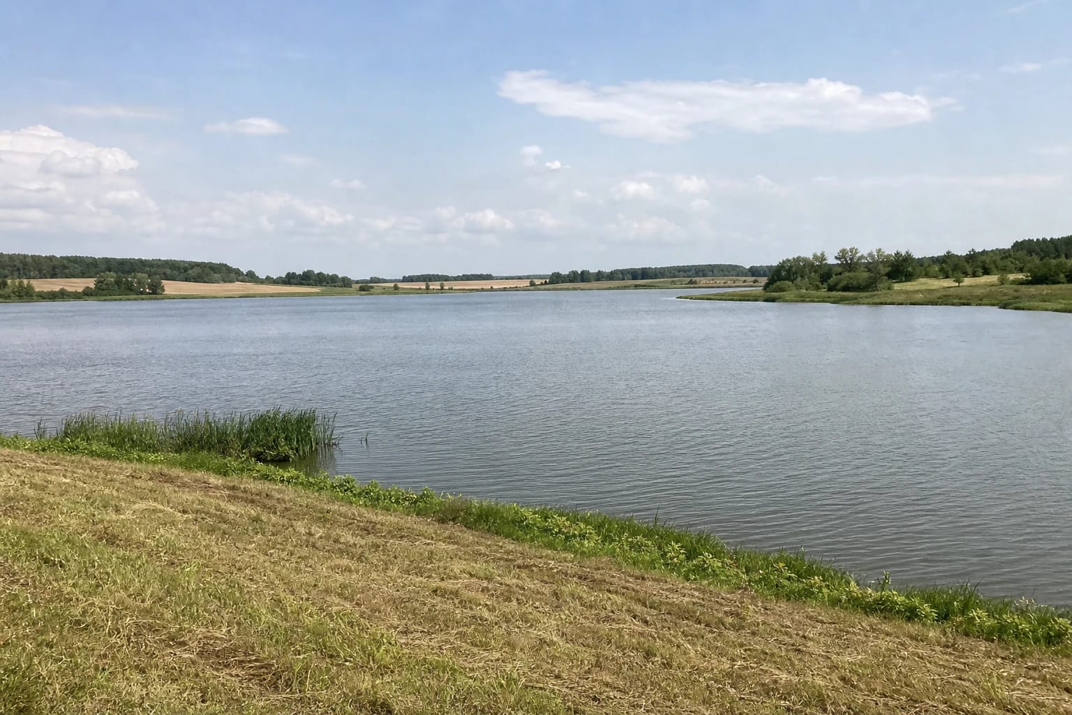
A photograph made for the exact site shows the pond as broad, calm lowland water. The foreground bank is cut grass with small patches of reeds, while the far side carries low mixed woodland, fields, and the direction of scattered homesteads. This is not a hilly lake, a steep bluff, or a heavily landscaped park.
The strongest impression comes from the scale of the water and the relationship between its shores. The surface is wide, but the banks remain rural: fields line some stretches, while shrubs and tree belts line others. Ground near the water can be soft and uneven, so a photo is safer from firm ground than by pushing through shoreline vegetation.
The pond is not separately described in official sources as a nature trail, and no viewing platform, pier, beach, or boat rental is confirmed. A facility at one shore or in a private use area should not be presented as infrastructure for the whole site.
Plan for a short landscape stop, not a guaranteed beach day
The official sources checked on 1 August 2026 publish no ticket, ticket office, opening hours, or public beach for Stepanionių Pond. Park only in a lawful place, without blocking an agricultural track, dam access, or residents' route. The representative coordinate is not a parking instruction.
A short stop to view the water and fields takes about 20-45 minutes. Fishing visits depend on the permit, chosen shore, and season. The Lithuanian Hunters and Anglers Association lists the pond as a water body, but that does not mean every shore is open for fishing without current rules or the relevant user's permission.
Plan swimming only if a clearly marked bathing place is operating there under current official supervision. The sources checked do not confirm one, a permanent lifeguard schedule, or current water tests that would justify calling the pond a safe bathing site. Keep away from the dam, outlet structures, and unfamiliar lakebed.
The 2026 public listing confirms interest, not site safety
The coordinate supplied on this page is representative of the pond, not a confirmed bathing place, jetty, or car park. Choose access through public roads, on-site signs, and land-use boundaries.
A calm water landscape may appeal to anglers, photographers, or people seeking quiet, but that does not prove wheelchair access, bathing quality, or open access across the dam. Those questions must be answered by the conditions and signs on the day.
The pond works best as a deliberate stop in Panevėžys District's rural landscape: view the water from a safe public shore, watch birds without chasing them, leave no litter, and keep vehicles off shoreline grass.