Trakai, Trakai District Municipality
Trakai Historical National Park
lake archipelago in Trakai Historical National Park
54.65249, 24.93392
1-2 hours for shore and island views; longer with the castle museum or a boat trip
May to October for island views; early morning for quieter Trakai
Galvė islands, Trakai Lake Galvė islands
The lake where islands create the Trakai view
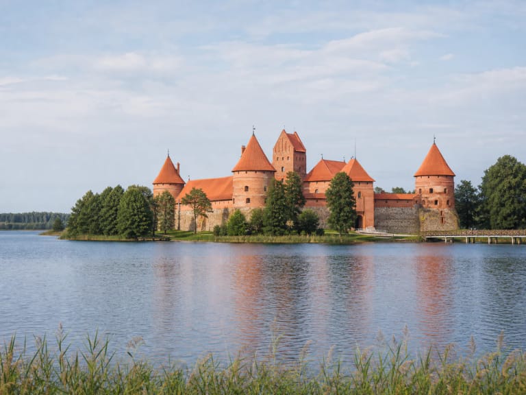
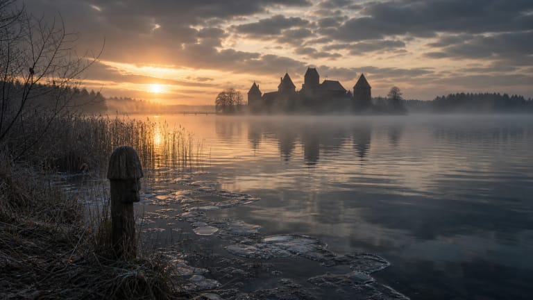
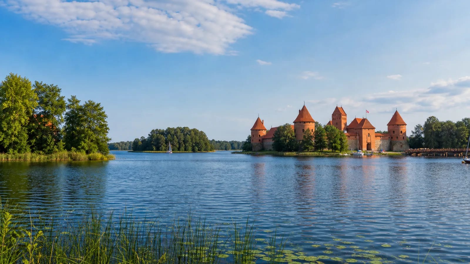
The islands of Lake Galvė are one of the main reasons Trakai looks so recognizable. VLE states that Galvė has 21 islands with a combined area of about 14.9 ha, most of them gathered in the southern part of the lake. The most important for visitors is Castle Island, where Trakai Island Castle stands.
These islands are not only decoration for photos. They explain why Trakai became a defensive, political, and representative centre: water protected, divided, and connected, while islands allowed a castle-and-town system to form in the middle of the lake. VLE notes that Galvė connects through Lakes Luka, Totoriškės, and Skaistis with neighbouring waters, so Trakai's peninsulas and islands form one water labyrinth.
Size, depth, and origin of Lake Galvė
VLE gives Lake Galvė's area as 361 ha, its length from north to south as 3.2 km, its greatest width as 1.75 km, and its surface altitude as 148.4 m. The greatest depth reaches 46.8 m and the average depth 13.6 m, making it one of the deepest lakes in southeastern Lithuania; its very winding shoreline is about 12 km long.
VLE describes Galvė as having a complex origin, both tunnel-valley and dammed. That means the basin was shaped by glacial channels and later water damming, so the lake is deep even though its surface around Trakai can look calm. Two streams flow into Galvė in the Neris basin, and the lake's water-throughflow is about 20 percent.
Castle Island and Trakai Island Castle
Castle Island is the most visited Galvė island because Trakai Island Castle stands there. VLE states that the castle occupies the whole island, about 1.8 ha, and that together with Peninsula Castle it belongs to the Trakai castles of the middle or second half of the fourteenth century to the beginning of the fifteenth. It is one of Lithuania's most important medieval residential and defensive sites, linked with the rule of Vytautas the Great.
The castle palace was rebuilt in 1953-1962 according to architect B. Krūminis' project, while the fore-castle was rebuilt in 1987 by architect S. Mikulionis. VLE notes ribbed star vaults, fifteenth-century fresco traces with Byzantine-style features, stained-glass windows, and a hypocaust heating system in the basement. Excavations in a cultural layer up to 4.5 m thick uncovered weapons and ceramics, and finds are kept in Trakai History Museum.
Island names and town memory
VLE lists the largest Galvė islands: Pilies, Plytinė, two Vidurinė islands, Deimantinė, Valka, Raudų sala, Pirtsalė, Velnė, Karvinė, Banda, and Bažnytėlė, also called Cerkvelė. These names help visitors read local memory and show that the lake was never an anonymous body of water for Trakai.
Not every name will be visible to a visitor on signs or maps, but the abundance of names shows that each island had practical, historical, or narrative meaning. Some islands are linked with brickmaking or baths, others with legends, so the archipelago is both natural and cultural heritage.
Castle museum, water sport, and visiting practice
Trakai History Museum operates inside the castle, so visitors should separate two things: the Galvė islands themselves can be seen from public shores without a ticket, while castle exhibitions follow museum hours and ticket rules, which should be checked on the official museum site. VLE also mentions sport bases on the southeastern and western shores of Galvė and water-sport competitions, so the lake is not only historical but actively used.
The great depth and many islands create different views from each side of town: from Karaimų Street one sequence of islands is visible, from Užutrakis park another, and from a boat their distances and the position of Castle Island become clearer. A boat or kayak is the best way to understand that Castle Island is not the lake's only feature.
How to see the islands best
For a first visit, walk the shores near Trakai Island Castle, pause on Karaimų Street, and look back at the lake from the Užutrakis park side. A boat or kayak helps most if you want to understand the archipelago, because only from the water do the 21 islands in the deep southern part of the lake become legible.
In season, Trakai is busy, so early morning or a weekday is best for island views and calmer photos. In winter, Galvė ice should not be treated as safe without official information: even when Trakai looks traditionally tied to a frozen lake, 46.8 m depth and inflowing currents mean uneven ice.