- Place
- Vilkaviškis District Municipality
- Region
- Suvalkija
- Type
- 1996 pedestrian overpass above Kybartai railway station yard
- Address
- At Kybartai railway station, between J. Basanavičius and Kudirkos Naumiesčio streets, Kybartai
- Coordinates
- 54.64120, 22.75846
- Visit duration
- 20-40 minutes; up to 1-2 hours with central Kybartai landmarks
- Best time
- a dry, calm day in full light; morning or late afternoon for the rail-yard panorama
Kybartai pedestrian overpass, Kybartai railway footbridge, pedestrian bridge over Kybartai railway station
A town crossing above the station, not a railway bridge over a river
The pedestrian overpass crosses the broad Kybartai railway-station yard and links the town centre with the part of Kybartai north of the tracks. It is an everyday connection carrying people above active railway lines. It should not be confused with the railway bridge across the Liepona near the state border or with infrastructure at the road border-control point.
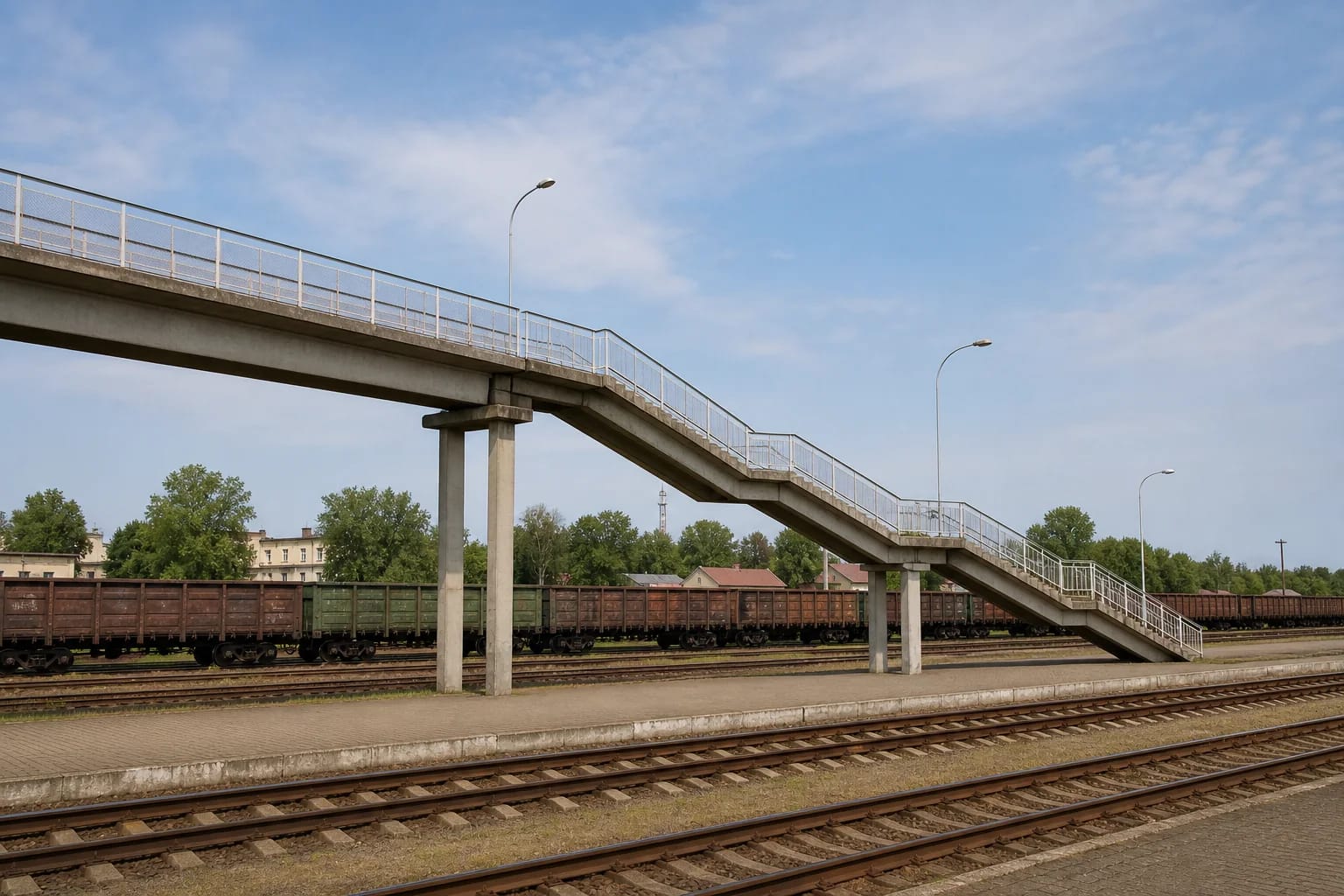
The long uncovered structure has a concrete deck and supports, several stair flights broken by intermediate landings, simple metal railings, and lighting columns. Its interest does not lie in ornament. Seen from the side, it makes exceptionally clear just how wide a railway junction this single pedestrian route has to cross.
The coordinate 54.641205, 22.758456 was calculated as the approximate midpoint of the linear overpass geometry mapped in OpenStreetMap. The pin identifies the structure above the tracks, not the foot of the stairs, a parking space, or platform access. Approach from one end of the bridge and follow local paths and signs.
The 1996 bridge and why published length figures disagree
The present reinforced-concrete pedestrian bridge opened in 1996. A television report at the time gave its length as 248 m, while later travel and local-history descriptions sometimes state roughly 285-287 m. Local reporting in 2017 noted that the owner had not provided a measured figure. The discrepancy may reflect different treatment of the horizontal deck, stair flights, and approaches.
A Vilkaviškis District strategic plan called the overpass Lithuania's second-longest and described it as a viewpoint. That is useful evidence of how the town presented the bridge at the time, but it is not a continuously updated national ranking. New structures and inconsistent measurement limits make 'one of Lithuania's longest pedestrian overpasses' more defensible than an unverified exact record.
The 2026 procurement notice identifies the object in engineering terms: the Kybartai station pedestrian overpass at kilometre 123+342 of the Kaišiadorys-Kybartai-state border railway line. This distinguishes it from other bridges around Kybartai, but the notice does not give a total length.
The railway grew Kybartai, and the old footbridge was a different structure
VLE links Kybartai's decisive expansion to the Kaunas-Virbalis railway completed in 1861 and the station built here. The border junction gave the town direction, trade, and an unusually extensive railway landscape. The present overpass therefore makes most sense not as an isolated lookout, but as a late response to transport infrastructure that had divided the town for more than a century.
Local historical research preserves a 1948 photograph showing an earlier wooden pedestrian bridge. Community accounts associate it with German construction, describe wartime damage, and say it was later demolished. These details belong to documented local memory rather than the engineering record of the present bridge.
The concrete overpass seen today is consequently not a surviving piece of the old wooden bridge. Their connection is functional: in different periods both allowed pedestrians to cross the railway space that simultaneously shaped and divided Kybartai.
Views across the yard, town, and borderward horizon
From the highest part of the overpass, the view takes in numerous tracks, platforms, stationary freight wagons, and station infrastructure. Beyond them are the tree canopy, low buildings, and vertical accents of Kybartai. It is a rare place where the town's structure can be read in one glance, although the exact scene changes with parked trains, vegetation, weather, and ongoing work.
Older descriptions mention the customs area and a view in the direction of Kaliningrad Oblast. This does not promise a clear foreign landmark or privileged access towards the border: the bridge remains in Lithuania, and visibility depends on distance, the horizon, and weather. The station yard itself is the more rewarding and reliable panorama.
Stay on the pedestrian route when taking photographs, never climb the railings, drop objects, or enter the tracks. Do not block the crossing, and obey signs and railway staff. Avoid close photographs of customs inspections, security equipment, or personnel. Do not assume ordinary tourist-flight rules apply to a drone here; current zones and permissions must be checked separately before any launch.
Reconstruction is still being designed, so do not promise lifts or ramps
LTG Infra's 2025 annual report says reconstruction projects had begun for pedestrian overpasses at Panevėžys, Radviliškis, and Kybartai stations, with design-service procurement under way. The stated aim after reconstruction is safer use and barrier-free movement for disabled people. That wording describes the intended result, not access already completed in Kybartai.
A dedicated procurement for the design and subsequent design-supervision services of the Kybartai overpass was published on 12 June 2026. Requests to participate were due by 13 July 2026, and the expected service-contract duration is 36 months. The official sources checked on 19 July 2026 did not announce a completed reconstruction or a confirmed construction-closure schedule.
The existing structure is reached by long flights of steps. Until the operator officially announces new barrier-free approaches as open, plan for stairs and do not expect independent wheelchair access. Travellers for whom stairs are a barrier, and anyone bringing a pushchair, should verify current conditions and a safe alternative route before arriving.
Practical visit: weather, steps, and live railway infrastructure
No separate tourist opening hours or admission fee are officially published because this is a town pedestrian connection rather than a museum. That should not be turned into a promise of permanent access: railway works, inspections, or the future reconstruction may change the route. If the bridge is your primary reason for travelling, assess signs on arrival and check the latest LTG or municipal notice on the same day.
Allow 20-40 minutes for one crossing, a closer look at the structure, and a few panorama stops. The viaduct is uncovered and exposed to wind, while its long stairs may be slippery after rain, frost, or snow. Wear secure footwear, use the handrails, never sit on them, and avoid standing on landings where you would obstruct other users.
No visitor car park dedicated to the overpass could be confirmed. Leave a car only in a legally marked town space and approach on foot without blocking railway, customs, or emergency access. Continue a short Kybartai circuit to the Church of the Eucharistic Saviour, or combine a longer Suvalkija day with Vilkaviškis, Marijampolė, or Kudirkos Naumiestis.