- Place
- Kaupiškiai, Vilkaviškis District Municipality
- Region
- Suvalkija
- Type
- state-protected first-millennium hillfort with a 1.5-hectare foot settlement and a recognised landscape viewpoint
- Address
- Kaupiškiai village, Vištytis eldership, Vilkaviškis District
- Coordinates
- 54.54111, 22.70167
- Visit duration
- 30-60 minutes for the hillfort and panorama; longer if you examine both the enclosure and the relief around its foot
- Best time
- a clear day in late spring or early autumn, when the grass is dry and the panorama across the fields of Sūduva is easy to see
Kaupiškių piliakalnis, Kaupiškiai Hillfort and Settlement
Kaupiškiai Hillfort stands where the hills of Sūduva begin to open into plains
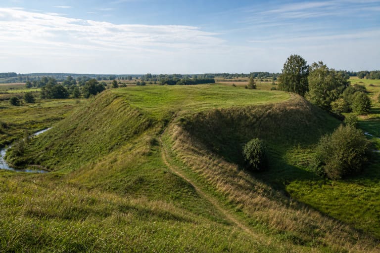
Kaupiškiai Hillfort stands in Vištytis eldership, west of Kaupiškiai village and close to Lithuania's present border with Russia's Kaliningrad Region. The hill marks a transition in the landscape: rolling uplands rise to the south and southeast, while increasingly level farmland extends north and east. This open setting makes the hillfort visible from a considerable distance.
From the enclosure, the eye follows strips of cultivated land, small groups of trees, and a distant horizon. The Ministry of Environment lists Kaupiškiai Hillfort among Lithuania's valuable landscape viewpoints. This is neither a tower nor an urban viewing platform: the panorama depends on the natural height of the hill and the largely unobstructed countryside of Sūduva.
The 74-by-30-metre enclosure preserves a changed landscape rather than intact ramparts
The hillfort was established on the summit of a large natural hill. Its oval enclosure is elongated from northeast to southwest and measures about 74 metres by 30 metres. The middle rises by more than three metres, so the surface is not level when walked from end to end. Its steep slopes reach up to 16 metres in height.
Nineteenth-century accounts mention ramparts, but later investigators could no longer identify clear remains. The loss was not caused by time alone: ploughing and trenches damaged the enclosure and slopes, while a gravel pit cut into the northeastern and eastern side. The smooth grassy profile seen today should therefore not be mistaken for an unchanged ancient fortification.
The Register of Cultural Property assigns the entire hillfort and settlement complex the unique code 22999. Its two constituent parts are the hillfort, code 3702, and the settlement, code 23000. The Cultural Heritage Department's 2021 monitoring record identifies both as monuments and describes their condition as unchanged since the preceding assessment.
Pottery and a 1.5-hectare settlement reveal a community beyond the summit
A cultural layer was observed in the enclosure and along the western and southwestern lower slope. An older archaeological description recorded roughly 0.3 metres of deposits in the enclosure. Finds include handmade pottery with roughened and smooth surfaces, fragments of everyday vessels that help date occupation at the site.
A settlement covering about 1.5 hectares was identified at the southwestern and northern foot. It produced the same types of rough-surfaced and smooth pottery. This changes how the place should be understood: the summit was not merely an isolated lookout but part of a complex connected to people living below. Published evidence does not, however, establish a complete building plan or a reliable population figure for the settlement.
The Kaupiškiai complex is broadly dated to the first millennium AD. This does not mean that a single castle stood continuously for a thousand years. The evidence supports occupation, pottery production or use, and the defensive choice of a prominent hill, but it does not provide the name of a documented castle, its ruler, or the date of a particular battle.
The site was surveyed, not opened by a large excavation
Staff of the Lithuanian Institute of History surveyed the hillfort in 1965, followed by the Scientific Methodological Council in 1972. These field visits recorded the shape of the enclosure, damage to the relief, locations where cultural deposits remained, and pottery found on the surface. Published descriptions do not report a large continuous trench across the enclosure or a reconstructed castle plan.
It is therefore important to separate finds from interpretation. The rough-surfaced and smooth pottery and the foot settlement are archaeological facts. Popular accounts sometimes place a specific castle here in the thirteenth or fourteenth century and connect it with wars against the Teutonic Order, but the current first-millennium date and limited surveys do not confirm so precise a story.
Jonas Basanavičius made Kaupiškiai part of a personal story of Lithuanian identity
The hillfort has a distinctive connection with Jonas Basanavičius, who grew up in nearby Ožkabaliai and became a leading figure of Lithuania's national revival. In his autobiography, he recalled becoming acquainted with Kaupiškiai after Pajevonys Hillfort and noted its position near the Prussian border of his time. Looking back on such places, Basanavičius wrote that his Lithuanian identity had grown stronger upon these hills.
That is a documented statement of personal and national memory, not proof of the age of a castle at Kaupiškiai. A further layer of memory appeared in the twenty-first century: a Baltic Unity Day fire was lit here in 2011 on a base of stones intended to protect the turf. The event reflects the community's contemporary relationship with Baltic heritage.
A local road and timber stairs lead to a free, stair-only summit
Approach from regional road 186 between Kybartai and Vištytis. At Kaupiškiai cemetery, turn west and continue for roughly one kilometre; the hill rises on the right, north of the local road. The registered site point is 54.541111, 22.701667. The last approach may be gravel or muddy after heavy rain, so check conditions and do not block farm access.
Timber stairs climb the slope, but the enclosure and approach remain uneven, and steep grass can be slippery after rain. These conditions mean that the summit is not step-free or wheelchair accessible. Visit in daylight, wear firm footwear, use the existing route, and do not cut directly across the protected slope.
This is an open outdoor heritage site without a ticket office, gates, or published opening hours. Check current access and road conditions before travelling. Because the route lies close to the European Union's external border, carry identification, follow all border signs, and do not continue beyond public access roads.