- Place
- Kapiniškiai, Marcinkonys eldership, Varėna District Municipality
- Region
- Dzūkija
- Type
- a natural spring and suffosion-hollow seep in the Skroblus valley
- Address
- the right-hand slope of the Skroblus valley by Kapiniškiai, Marcinkonys eldership, Varėna District
- Coordinates
- 54.02741, 24.29884
- Visit duration
- 20-40 minutes at the spring; several hours when combined with the full 12.4 km Skroblus Nature Trail
- Best time
- in daylight, with good visibility and in accordance with current trail and private-property signs; after rain, wear footwear suited to wet ground
Antončiko šaltinis, Samardotiškiai Spring, Verduolis
Antončikas, Samardotiškiai, and Verduolis are three names for the same spring
The Lithuanian Geological Survey uses Antončiko šaltinis as the main name and lists Samardotiškių šaltinis and Verduolis as synonyms. Its location note connects the first name with Pranas Antončikas, whose name local people in Kapiniškiai used to identify the spring. These are three names for one site, not three separate springs.
The spring lies in Varėna District, near the middle of elongated Kapiniškiai village in the Skroblus valley. It emerges at the base of the right-hand valley slope, on the western edge of Darželiai forest. Saugoma.lt publishes the rounded point 54.027, 24.298, while the exact Google card marks 54.0274106, 24.2988368.
The Geological Survey gives LKS coordinates 519581 and 5987807 and places the site in Kapiniškiai Landscape Reserve within Dzūkija National Park. Coordinates distinguish Antončikas from the Bobos daržas springs near Margionys, but the final approach should follow current signs rather than a straight navigation line.
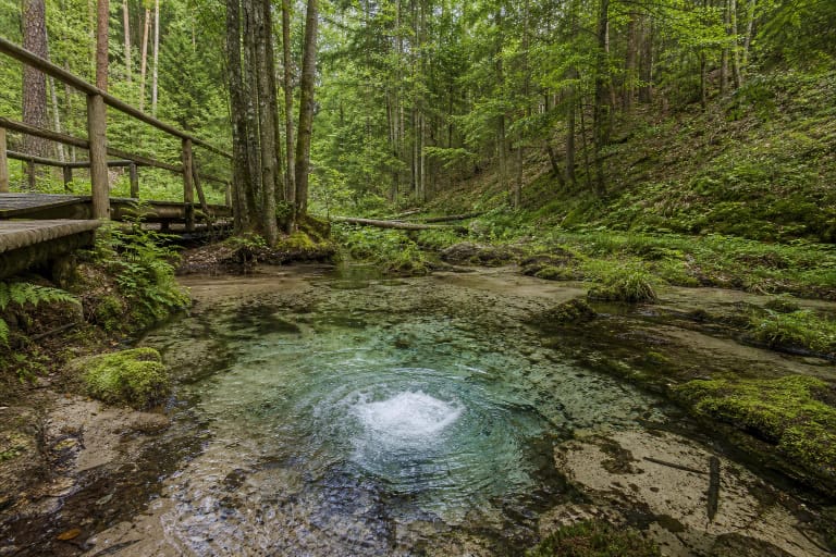
Two adjacent vents churn yellow sand at a depth of more than 1.5 metres
Groundwater reaches the surface through two vents lying side by side. The upward flow continually washes, sorts, and shifts the yellow sand, creating visible rings in the basin. This is not bubbling gas: the Geological Survey observed no gas release when it examined the spring.
The spring basin is approximately 1.6 metres wide and 2 metres long. At the upwelling points beneath the moving sand, firmer ground is reached only at about 1.5 metres, while Saugoma.lt describes the depth as exceeding 1.5 metres. Visitors must never wade into the basin, probe it with sticks, or attempt to verify that depth themselves.
By washing the sandy slope, the water has formed a crescent-shaped suffosion cirque. The spring sits below a now stable slope 25-30 metres high, among young pines, hazels, and alders in the wetter hollow. This is an intimate landform to observe close up, not a broad viewpoint.
A flow of about 4 litres per second runs another 250 metres to the Skroblus
Hydrological figures cited by the Geological Survey give a discharge of about 4 litres per second, equivalent to 14-15 cubic metres per hour, and describe the spring as perennial. Water leaving the basin first enters a saturated hollow descending beside the slope, then gathers further flow from smaller seeps in the slope and valley floor.
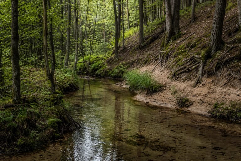
The spring stream winds for about 250 metres before reaching the Skroblus and is partly hidden by reeds in the marshy valley. That distance explains why the map pin must identify the source rather than the place where its stream joins the river. There is no need to follow the water across the wet hollow, and doing so would damage a sensitive habitat.
The spring opens where older alluvial sands meet glaciofluvial sand deposits. The sorting effect is pronounced: in the Geological Survey analysis, fine particles between 0.25 and 0.06 millimetres made up about 75 per cent of the sand being reworked in the vent. The constant interaction of water and sand is the defining sight here.
Measurements from 2014 describe the water but do not guarantee present-day drinking safety
A field reading on 17 April 2014 recorded a temperature of 7.8 C, pH 7.87, conductivity of 232 µS/cm, and dissolved oxygen of 7.81 mg/l. The laboratory description classified it as a calcium-magnesium bicarbonate-sulphate water, with 226 mg/l of dissolved minerals and 1.3 mg/l of nitrates.
The Geological Survey described the water at that time as clear, odourless, soft, and used for drinking; nitrite and ammonium were not detected in the reported analysis. Those figures describe one historical test, not a continuously renewed microbiological certificate. Conditions can change with season and surroundings, so this page does not recommend drinking without current official confirmation.
Google categorised the place as a drinking-water fountain, but a user-maintained map category is not a substitute for a safety assessment. Visitors should also keep containers out of the bubbling basin, avoid disturbing the sand, and never alter the small timber channel if it remains at the site.
Official routes support visiting, but the conditions on the short access spur can change
The Geological Survey described an approach along a lane winding through Kapiniškiai on the right bank of the Skroblus, then marked as an interpretive cycling route. From a sign beside the lane, a path crossed roughly 40-50 metres of meadow to the spring, where there was a small railed platform and timber channel. These observations date from 2012-2014 and do not prove that every piece of infrastructure remains unchanged in 2026.
The current Saugoma.lt object card presents Antončikas Spring as a visitor site, and its official Marcinkonys, Darželiai, Kapiniškiai, and Margionys cycling route explicitly includes the spring among its stops. The national-park authority separately publishes a 12.4 km Skroblus Nature Trail connecting Margionys and Kapiniškiai, but its trail description does not specifically identify the spur to this spring.
Check the official map before travelling and follow signs on the ground. Do not drive across a private meadow, block a homestead entrance, or create a shortcut through the wet valley floor. If a sign is missing, the path is closed, or notices restrict access, turn back and ask the park visitor centre for current guidance.
The 5.0 rating rests on two reviews, and a good visit leaves the spring untouched
The exact Google Maps card Antončiko šaltinis, place ID ChIJAcmDPwAj3kYRydeqdVZE3ew, showed 5.0 out of 5 from two reviews on 15 July 2026. This clears the required 4.5 threshold, but a two-vote sample is exceptionally small and one new rating could change the average immediately.
The official sources checked publish no separate ticket office, admission charge, or opening hours for Antončikas Spring. That does not authorise access at any time of day. Visit in daylight, obey national-park, reserve, private-property, and forest-road signs, and check official information on the day of travel.
Twenty to forty minutes is normally enough at the spring itself. Photograph it from the platform or another clearly permitted point, never enter the basin, touch the moving sand, or throw coins. For a longer outing, combine it with the Skroblus stream, Bobos daržas springs, Bakanauskai Mire, and Margionys, moving only on marked routes.