Varnupiai, Marijampolė Municipality
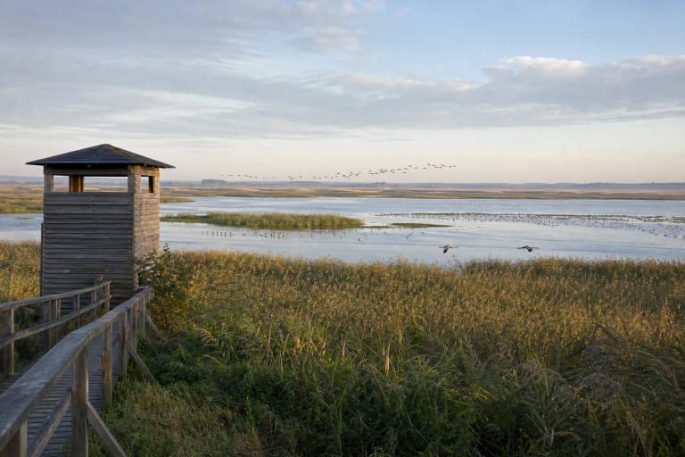
Žuvintas Biosphere Reserve
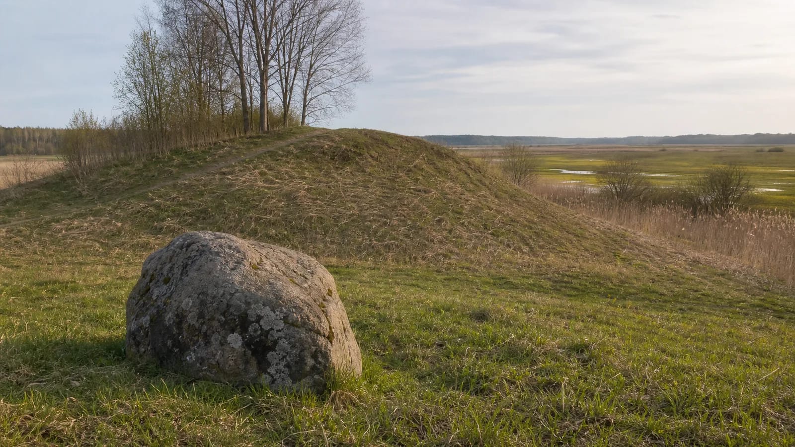
hillfort with an ancient settlement and mythological stone in Žuvintas Biosphere Reserve
54.49000, 23.53400
45 minutes-1.5 hours
dry spring or autumn, when the hill is easier to visit and sensitive wetlands are less disturbed
Varnupiai Hillfort and the mythological stone Padkavinis, Padkavinis
The largest archaeological monument in Žuvintas Reserve
Saugoma.lt presents Varnupiai Hillfort with its ancient settlement as the most significant and largest archaeological monument in Žuvintas Biosphere Reserve. This matters because Žuvintas is usually associated with birds, wetlands, and the lake, while Varnupiai reveals another layer: human settlement and memory. Saugoma.lt states that people lived in this area between the Žuvintas and Amalvas wetlands already in the Stone Age.
The hillfort lies among sensitive natural areas of southern Lithuania, so visiting it must combine archaeology with nature protection. The hill cannot be separated from the surrounding wetlands, meadows, and reserve rules. VLE states that the hillfort is in Varnupiai, Igliauka Eldership, Marijampolė Municipality.
Form, slopes, and ramparts
VLE states that the slopes of Varnupiai Hillfort are steep and up to 12 m high, while the oval platform measures 18 x 25 m. The platform is encircled by a rampart up to 3 m high and up to 18 m wide: a strong defensive construction showing that the site was seriously fortified. Saugoma.lt adds that the hillfort is thought to have been built by human hands and that much timber was used in the rampart construction.
VLE also records an outer defensive line at the foot of the hill: a 0.2 m deep and 3 m wide ditch, beyond which a 0.4 m high and 4 m wide rampart was built. Unfortunately, the hillfort has been damaged. VLE notes Second World War trenches and grave robbers as causes, so visitors should be especially careful not to walk where erosion is active and never dig or disturb the soil.
Jotvingian culture and dating
Saugoma.lt states that archaeological finds from Varnupiai Hillfort are assigned to Jotvingian culture and dated to the first millennium-13th century. That gives the site a southern Lithuanian, or Sūduva, context different from the hillforts of Panemunė or Samogitia. VLE dates the hillfort somewhat more broadly, from the end of the first millennium BCE to the 13th century CE.
The Jotvingian link should be understood as a cultural and archaeological horizon, not as a simplified label. The visitor sees a hill, but its meaning comes from the wider regional history: the Jotvingians, or Sudovians, were one of the Baltic tribes living south of the Lithuanians and later declined during wars with the Teutonic Order.
Excavations and finds
VLE states that Varnupiai Hillfort was investigated in 1971 by a Vilnius University expedition led by Petras Kulikauskas. In a 200 sq m area, in a cultural layer up to 4.8 m deep, archaeologists found hearths, postholes, and remains of wooden buildings. This shows that wooden structures stood on the hill and that life here was not merely temporary refuge.
VLE lists the finds as slag, flint blades, an iron knife, and fragments of ceramic objects. Slag points to iron working, flint blades reach into deeper prehistory, and the iron knife and ceramics show everyday life in the Iron Age. These finds make Varnupiai not just an impressive hill but also a scientifically investigated archaeological monument.
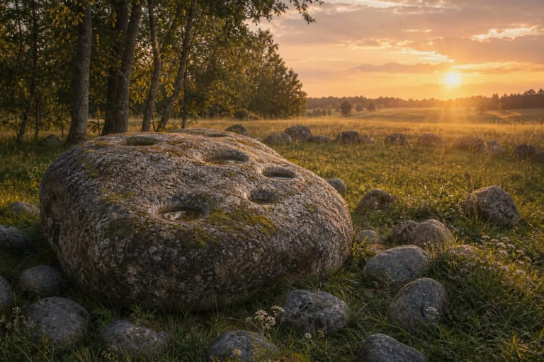
Padkavinis: the mythological stone
Beside the hillfort, sources mention the mythological stone Padkavinis, which is included in the official object name. The stone's name and mythological status show that the landscape carried a narrative meaning, not only a practical or defensive one. In Lithuanian tradition, such stones are often linked with footprints, marks, or rituals, and their names preserve local memory.
Mythological stones should be presented carefully: stories and names help explain local memory, but they are not documentary descriptions of events. It is best to understand them as a folklore layer beside the archaeological site, complementing rather than replacing the documented history of the hillfort.
Žuvintas Reserve rules and visiting
Varnupiai Hillfort is in Žuvintas Biosphere Reserve, so visitors must follow protected-area rules. The reserve's value lies in birds, wetlands, habitats, and landscape quiet; not every surrounding area is meant for free walking. Use official visiting directions, do not drive across meadows, avoid disturbing birds, and do not approach sensitive wetlands on your own. Saugoma.lt warns that the site is not adapted for people with reduced mobility.
Allow 45 minutes to 1.5 hours. The best time is a dry spring or autumn day, when the relief is easier to see and there is less risk of damaging sensitive ground. Combine the trip with Žuvintas visitor information, Lake Dusia, or Lake Metelys so Varnupiai becomes part of a southern Lithuania route of lakes, wetlands, and archaeology.