- Place
- Vilkaviškis District Municipality
- Region
- Suvalkija
- Type
- natural grass-covered hill and landscape viewpoint without a tower
- Address
- Svirkalnio g., between Duonelaičiai and Karpiejai villages, Gražiškiai eldership, Vilkaviškis District
- Coordinates
- 54.49708, 22.93473
- Visit duration
- 30-60 minutes for the hill and panorama; up to 1.5 hours for a slow walk on roads where public access is permitted
- Best time
- a clear, dry evening for the panorama and sunset, or early spring when tall grass does not obscure the relief of the Širvinta valley
Svirkalnis, Svirkalnis Hill, Svirkalnis Viewpoint and Campsite
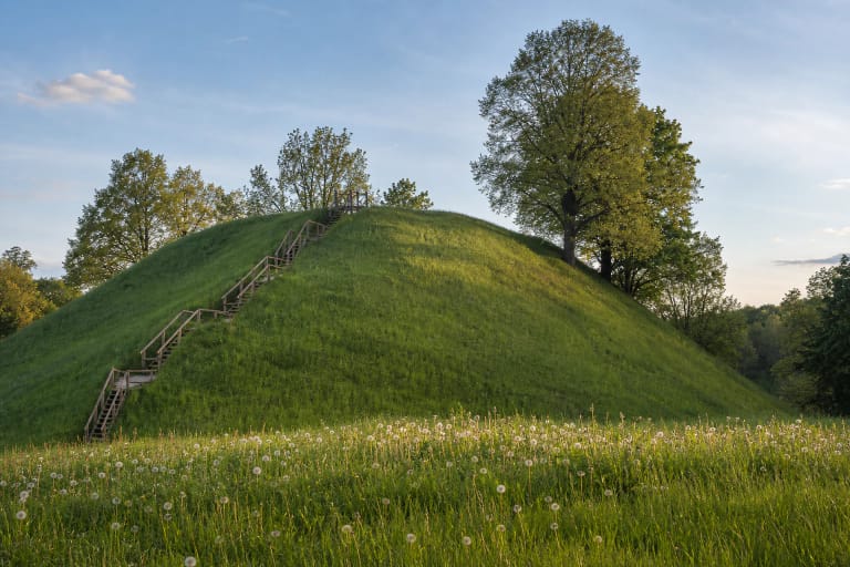
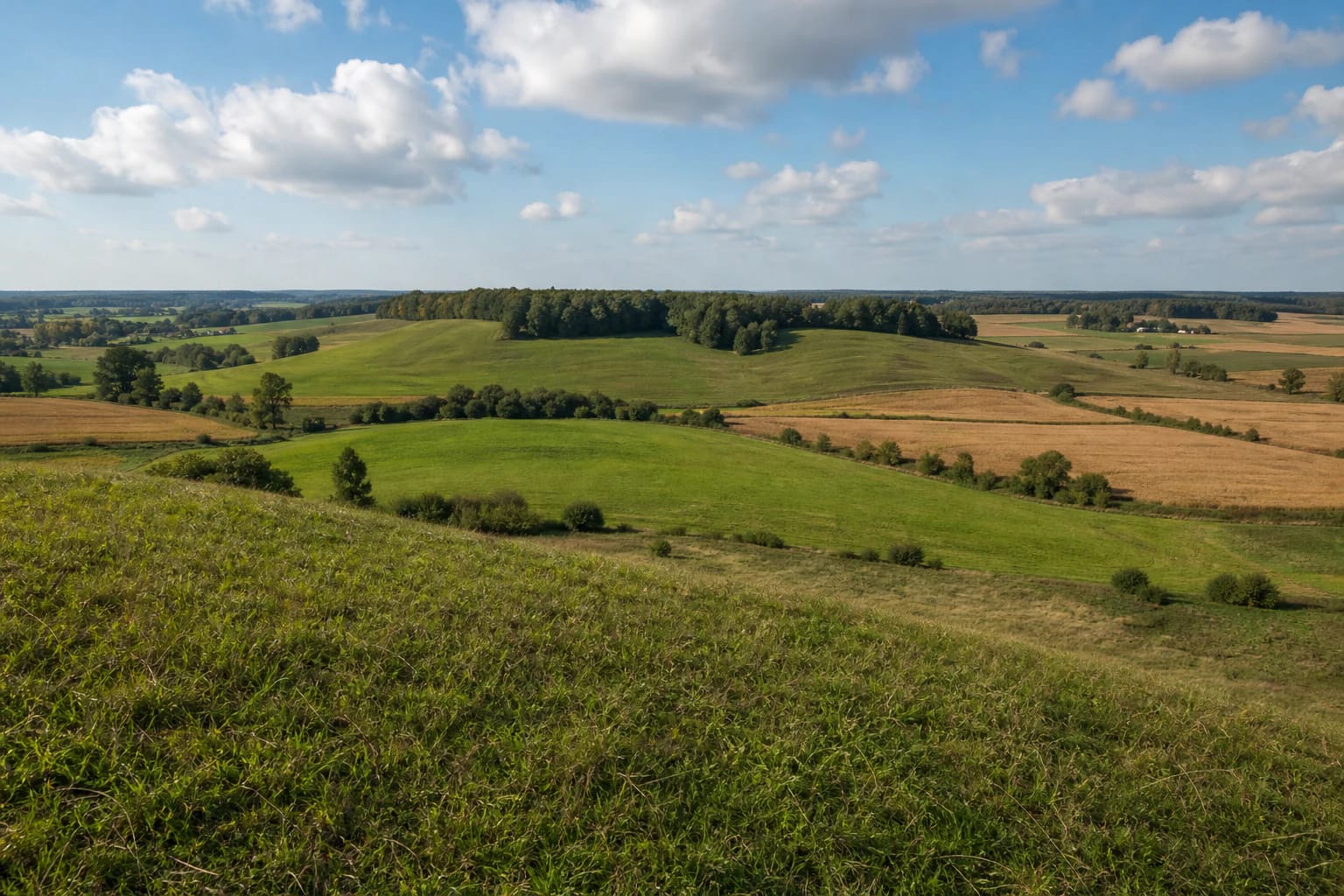
Svirkalnis is a natural hill, so do not arrive expecting a tower or raised platform
Svirkalnis Viewpoint lies in southern Vilkaviškis District, in Gražiškiai eldership, between the villages of Duonelaičiai and Karpiejai. The exact public Google Maps pin is 54.4970812, 22.9347328. Some sources associate the site with Duonelaičiai, others with Karpiejai, while an older municipal document places it in the direction of Pajevonys. These descriptions refer to the same hill beside local roads, not to several different viewpoints.
The Lithuanian word regykla can suggest a purpose-built lookout, but there is no tall timber or metal structure here. The viewpoint is the broad hill itself, rising in smooth, grass-covered folds. Small groups of birch and lime trees occupy parts of the crest and slopes, while most of the horizon remains open. The site's chief quality is not architecture but the ability to see the relationship between fields and river valley at a glance.
The Environment Ministry's official list of Lithuania's most valuable landscape panorama points records the site as Svirkalnio regykla. Its official LKS-94 coordinates, 430975 and 6040510, mark a point several dozen metres from the Google pin. In practice both indicate the same open part of the hill, but the public place listing is more convenient for navigation. On the final approach, pay attention to signs and land-use boundaries rather than treating every field track as public access.
The river below is the upper Širvinta flowing to the Šeimena, not the different border river
One of several Lithuanian rivers called Širvinta winds below the hill. This is the 54 km left tributary of the Šeimena, rising in the Sūduva upland near Armudiškiai and flowing north through Alvitas. It should not be confused with the other river in Vilkaviškis District, also known as Šervinta or Senaširvintė, part of which follows Lithuania's border with Russia's Kaliningrad Region.
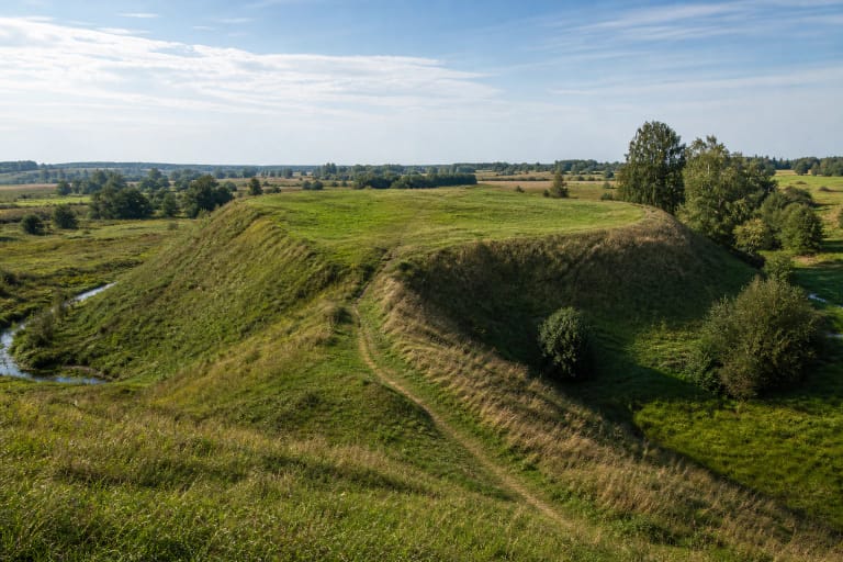
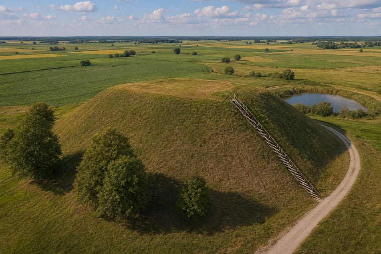
At Svirkalnis the river is still in its upper course. The hill reveals an incised valley dividing the meadows in bends, wet hollows on the lower ground, and cultivated fields arranged higher on the slopes. Local route descriptions mention water backed up by beavers, but water levels, dams, and visibility change naturally. A particular pond should not be treated as a permanent feature guaranteed to every visitor.
Farther away, the horizon is formed by rolling fields, shelter belts around farmsteads, and the direction of Gražiškiai. VLE describes Gražiškiai as a small town on the Širvinta and its tributary the Gražupis, about 13 km north-east of Lake Vištytis. In clear weather the town's direction and the vertical accent of St Michael the Archangel Church can help with orientation, but foliage, crop height, and haze determine how many individual landmarks can actually be identified.
Read the panorama slowly, from the valley floor to the moraine hills on the horizon
Svirkalnis presents Suvalkija as something more varied than an uninterrupted plain. The Sūduva upland rises across southern Vilkaviškis District, where glacial hills, depressions, and narrow river valleys contrast with the flatter Užnemunė lowland farther north. From the viewpoint, that transition is visible in fields climbing the slopes and ending at wetter hollows.
Start where you can safely see the bends of the Širvinta and follow the river in both directions with your eyes. Then study the opposite slopes. Lines of trees often trace watercourses, field boundaries, or steeper ground, while open patches reveal the true scale of the hill. Binoculars help with distant buildings and birds, but the landscape makes most sense as a wide, unzoomed composition.
Low morning light throws the valley folds into relief, while the open western and south-western horizon suits sunset visits. Colours can be especially rich after rain, though the grass and approach road may then be slippery. Snow exposes the relief exceptionally well in winter, but an unploughed local road and ice on the hill can matter more than the view.
Local memory explains the name and wartime traces, but these are not archaeological findings
Local tradition offers at least two explanations for the name Svirkalnis. One links it to the hill's uneven, apparently leaning or swaying form. Another recalls forked trees from which people made the long sweeps used to draw water from wells, and an older form of the name, Svirtkalnis. Both are meaningful pieces of place-name folklore rather than a single etymology conclusively established by linguists.
Accounts collected in the local press preserve residents' memories of Second World War trenches, fighting in 1944, and military machinery covered by earth. People also tell of partisans hiding in the area after the war. Such stories reveal the community's relationship with the hill, but the official landscape and planning sources reviewed for this page do not confirm the position of a buried tank, a particular bunker, or an archaeologically investigated partisan hideout.
Svirkalnis should therefore not be described as a hillfort, a formal battle memorial, or a documented partisan headquarters. Hollows in the ground may have several origins, and digging or using a metal detector without the required permission is inappropriate. The useful distinction is between the documented status of the viewpoint and the river's geography on one hand, and compelling but currently unverified local memory on the other.
The final road is easiest in dry weather, and the word campsite does not guarantee facilities
Navigate to the exact Svirkalnis Viewpoint listing or its coordinates, because entering a village name alone can place you on the wrong side of the hill. The last section is a narrow local road beside cultivated land. Its surface, ruts, and passability vary with the season and farm work. Park only where you will not obstruct access or enter crops; when the ground is wet, it is safer to walk the remaining distance.
Some route brochures call this a viewpoint and campsite, but the official sources checked on 15 July 2026 published no booking system, attendant, drinking water point, toilet, electricity, or guaranteed fire ring. Plan for a simple outdoor rest and viewing place. Consider a tent, fire, or overnight stay only if current signs, the landowner's rights, and fire-safety rules clearly allow it.
The official documents publish neither a separate ticket nor staffed opening hours, while the public Google listing marks the place as accessible 24 hours. That does not promise lighting or safe conditions after dark. No confirmed level trail, handrail, or universal access route is provided, so the terrain may be unsuitable for wheelchairs and visitors with limited mobility. Daylight, firm footwear, tick protection, and respect for crops matter more here than a nominal timetable.
Combine the short panorama stop with Gražiškiai, Ožkabaliai, and the hillforts of Sudovia
Allow 30-60 minutes for Svirkalnis itself: climb safely, change viewing direction several times, and take time to understand the Širvinta valley. Walk farther only on public roads or routes where access is clearly permitted, since an open field is not an invitation to cross growing crops. A municipal plan mentions a demanding spring paddling section of the Širvinta at Svirkalnis, but that is a seasonal activity dependent on water level and experience, not an everyday visitor route maintained by the viewpoint.
In Gražiškiai, St Michael the Archangel Church and the town's position on the same Širvinta provide a useful continuation. Jonas Basanavičius's birthplace at Ožkabaliai adds cultural context, while Piliakalniai and Pajevonys hillforts show relief deliberately reshaped for defence. Travelling towards Vištytis extends the route through the regional park's hills, lake, and other viewpoints.
On 15 July 2026, the exact Google Maps listing for Svirkalnis Viewpoint averaged 4.8 out of 5 from 26 reviews. That is a high score from a modest sample and will change over time. The place best suits visitors looking for a quiet landscape and comfortable with the absence of a tower, cafe, or substantial visitor infrastructure.