- Place
- Kaunas City Municipality
- Region
- Kaunas
- Type
- human-made stone cascades in the Marvelė stream and a landscaped public space in the urban valley
- Address
- Julijanavos Street by the junction with road 1903 Akademija-I fortas, Kaunas
- Coordinates
- 54.88035, 23.86844
- Visit duration
- 45-90 minutes for the cascades, bridge, and landscaped valley; allow longer only if making a separate visit to Fort I
- Best time
- daylight after a wetter spell, when the stream is more visible; after heavy rain and in winter, take particular care on slippery steps and stones
Marvelės kaskados, Marvelės upės slėnio kaskados, Marvelė waterfall, Marvelė serpentine cascades
Where the Marvelė Cascades are and what the map pin means
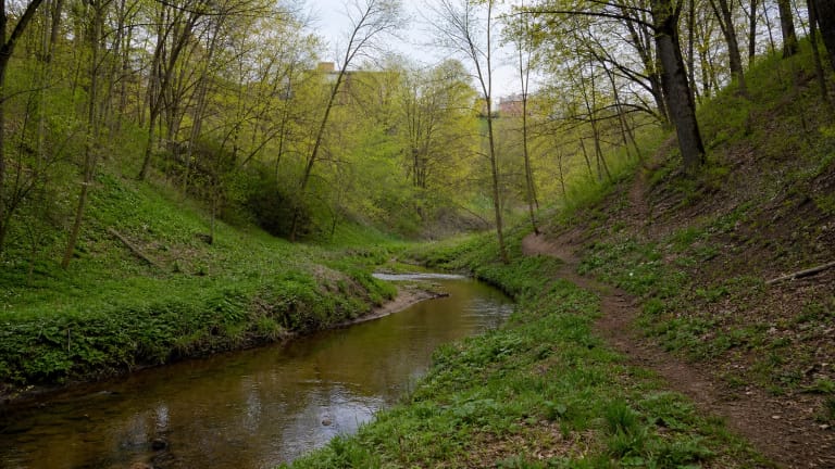
Marvelė Cascades are reached from Julijanavos Street near road 1903 Akademija-I fortas, in a valley between the Aleksotas ward of Kaunas and Ringaudai ward in Kaunas District. VLE defines Marvelė as a district of Kaunas on the left bank of the Nemunas, but the attraction lies in a green hollow on the city's south-western fringe, not at the centre of the residential district or beside the Nemunas embankment.
Coordinates 54.880351, 23.868436 identify the cascades and historic bridge area. They do not indicate the only legal parking space, the formal beginning of a marked walk, or a surveyed centre point of the bridge. Select the dedicated Marvelė Cascades listing in your navigation app, then follow local signs and parking restrictions for the final approach.
Marvelė waterfall is a convenient colloquial name but a misleading geographical description. The stream runs over a human-built sequence of stone steps rather than a natural rock face, so cascades is the more accurate term. Lithuanian descriptions also use the name serpentinai for the stepped system that controls the descent.
1881 or 1882: what is known about the bridge and cascades
The cascades are associated with the early construction of Kaunas Fortress and with the historic road whose route is now Julijanavos Street. The information board at the site says that the Marvelė river bridge and cascades were built in 1881. A 2020 Kaunas City Municipality article identifies the bridge as a fortress structure and dates it to 1882.
Those two officially published dates should not be forced into false agreement. The safest conclusion is that the bridge-and-cascade complex originated in 1881-1882 during the first phase of fortress works. A difference may reflect whether a source refers to installation of the cascades, the start of bridge construction, or completion of the structure.
Popular accounts suggest that the steps dissipated the energy of water descending the steep valley and protected the bridge approaches and stream bed from erosion. This is a plausible hydraulic purpose, but the municipality pages checked for this guide do not reproduce the original nineteenth-century engineering specification. It should therefore be understood as a reasoned explanation rather than a direct archival statement.
From the 2012 footbridge to the 2017-2019 valley renewal
The neglected valley was maintained for years through local community effort. In 2012, an initiative by the Aleksotas community and ward installed steps and a footbridge across the Marvelė stream, making direct visits to the cascades possible. That intervention improved access but did not yet create the full public space seen today.
A Kaunas City Municipality project worth EUR 240,000 was implemented in 2017-2019. It renewed footpaths, installed outdoor lighting and street furniture, stabilised a slope, and created a stage plaza with amphitheatre-style seating. Another area for cultural events was formed near Julijanavos Street, while storm-water drainage, lighting, and electrical networks were upgraded.
The community added a short wellness trail in 2020. An official city tourism page updated in late 2025 still presented the valley as adapted for visitors, and no municipality notice closing the whole site had been found by July 21, 2026. This is not a real-time inspection of every surface or item of equipment: storms, heavy rain, ice, or maintenance can make part of the route temporarily inaccessible.
Water levels change, and the cascades are not a paddling pool
The appearance of the cascades depends on the flow of the Marvelė stream. Water is generally more conspicuous after wet weather and in spring, while a dry summer can reduce it to a thin ribbon. The broad white veil shown in some photographs is not guaranteed in every season.
Stone, moss, the wooden footbridge, and valley steps can be slippery even in warm weather. A stronger current after rain is not an invitation to climb the tiers, enter the channel, or walk beneath the bridge. In winter, the cascades can acquire striking layers of ice, but neither the ice nor the wet masonry is maintained for climbing or skating.
Official sources do not identify the cascades as a bathing place, drinking-water point, or water attraction, and no recent public microbiological test was found. Watch the water from the path and footbridge, keep children close, do not dislodge stones, and leave no litter in the stream.
Access, a short circuit, and the unfinished idea of a path to the Nemunas
Within the landscaped part of the valley, visitors can view the cascades, cross the footbridge, pause by the amphitheatre, and follow the public-space paths. A slow visit takes about 45-90 minutes. A 2020 municipality community article still described a route beside the stream to the Nemunas as a future ambition, so this guide does not promise a continuous marked nature trail from the cascades to the river.
No single current official page publishes parking capacity or fees, the relevant public-transport service, and toilet availability. Park only where signs permit and do not obstruct the Julijanavos Street approaches. Check the official same-day timetable rather than relying on a route number copied into an evergreen guide, and remember that an event or nearby works can alter the usual approach.
The valley is steep, and one principal approach includes a long flight of concrete steps. The municipality project confirms renewed paths and a stabilised slope but does not provide an independent 2026 audit of a step-free route from a parking place or stop to a clear view of the cascades. Wheelchair users and visitors with limited mobility should ask Aleksotas ward about the present lower access, surfaces, and footbridge before travelling.