- Place
- Gandinga, Plungė District Municipality
- Region
- Žemaitija
- Type
- nationally significant hillfort occupied from the first millennium to the mid-second millennium, the principal Curonian castle site in the Gandinga archaeological complex
- Address
- Gandingos Piliakalnio Street, Gandinga village, Nausodis Eldership, Plungė District
- Coordinates
- 55.88665, 21.77168
Gandingos I piliakalnis, Gandinga Hillfort, Gondinga Hillfort, Gondinga Castle, Pilies kalnas
Google's Gandinga Hillfort I is the principal Gondinga castle hill, not the entire five-hillfort complex
The exact listing leads to the eastern edge of Gandinga village at 55.8866547, 21.7716818. The Register of Cultural Property protects the whole hillfort, outwork, and settlement complex under code 23967, while the principal castle hill has its own code, 5468. The Roman numeral I in Google's name distinguishes it from Gandinga Hillfort II and the nearby Nausodis and Varkaliai hills.
Access is from Gandingos Piliakalnio Street; local paths descend into the Babrungas valley and climb the hill. Allow 1-1.5 hours for the hillfort, outwork, and riverside section, or 2-3 hours to extend the route to other archaeological sites. It is a free outdoor attraction without fixed opening hours or a ticket office.
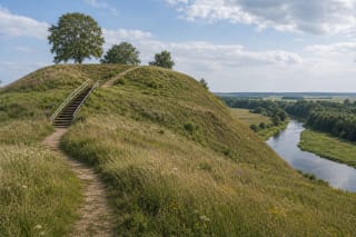
A road and valley path do not make the summit fully accessible. The heritage record documents steep slopes, locally up to 40 metres high and affected by landslips; earth, grass, and stones become slippery after rain. Wheeled visitors can see part of the foot landscape, but the ascent is not a barrier-free route.
The Babrungas and ravines supplied natural defence, while a 70-metre rampart closed the castle on the west
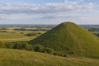
The hillfort occupies a high promontory on the Babrungas right bank, enclosed on its north, east, and south by the river and valley. The current heritage act describes an oval north-south plateau of approximately 80 by 35 metres. VLE, following an older measuring convention, gives 100 by 55 metres; these figures likely define eroded plateau edges differently rather than referring to two hillforts.
A rampart 70 metres long, around 30 metres wide, and up to four metres high runs along the western and north-western edge. A second bank about eight metres wide and one metre high occupies the southern edge, while a natural terrace extends for about 70 metres on the eastern slope. In the older VLE description, the main bank rises as much as eight metres from its adjacent ditch, so recognising its curved mass matters more on site than seeking one absolute height.
The Babrungas did more than defend. It undercut the promontory, causing sections of the plateau and eastern, south-western, and northern slopes to slide. In the early 20th century, Ludwik Krzywicki investigated the eroding edge and documented multiple episodes of rampart rebuilding. Walking on the cliff lip or cutting directly up a slope consequently damages an archaeological structure.
The castle hill, outwork, and six-hectare settlement formed one residential and defensive centre
A separate outwork spreads west of the fortified summit: a broad irregular platform with its own low bank and ditch. It occupied an intermediate space between the strongest castle defences and everyday settlement, so a view from the summit alone misses much of the complex's scale.
The ancient settlement covers about six hectares. It preserves up to 60 centimetres of dark cultural soil containing hearths, fire-cracked stones, iron slag, clay daub, and archaeological objects. These traces document buildings, craft, and daily life below the fort, although the surface now appears as meadow and cultivated land rather than reconstructed houses.
The complex is dated from the first millennium AD to the middle of the second. Archaeologists from the Institute of History surveyed it in 1949 and 1964, with small exploratory excavations in 2007 and 2009. Those trenches covered very limited areas, so an empty test pit cannot make the whole extensive settlement empty, just as one object cannot reveal a complete town plan.
The name Gandingen in 1253 places the hill in the political geography of the Curonian land of Ceklis
The heritage register associates the hillfort with the castle Gandingen, Gandinghen, or Gandinga named on 5 April 1253 in an agreement dividing southern Curonian lands between the Livonian Order and Bishop Heinrich of Courland. This places it within Ceklis, one of the Curonian territories, and provides a firmer starting point than later legends of battles with crusaders.
A concentration of five hillforts, cemeteries, a sacred hill, and settlements indicates that the Babrungas bends held an important centre rather than an isolated refuge. Yet the hills did not necessarily operate simultaneously and each was not a separate castle. Archaeological complex describes a spatial concentration of protected sites, not a five-castle city existing at one date.
Gandinga cemetery lies approximately 0.84 kilometres north-west of the main fort. It has produced inhumation graves from the 11th and 12th centuries and isolated objects from the 5th to 8th centuries, including penannular brooches, cross-shaped pins, spearheads, and clay weights. The sacred hill called Apieros kalnas lies farther away, about 2.4 kilometres from the main hillfort, and should not be confused with the castle plateau.
New historical research rejects the simple story that the town of Gandinga burned and moved to Plungė
Popular accounts repeat that a large town of Gandinga survived until the 17th century, was destroyed by Swedes and plague, and relocated to Plungė. In 2022, Lithuanian Institute of History researcher Jonas Drungilas examined archaeological, historical, geographical, and linguistic evidence and reached a different conclusion: there is no archaeological evidence for a 16th- or 17th-century town beside the Gandinga hillfort.
The word mesto used beside Gandinga in documents of 1567-1570 did not necessarily denote a physically located town here. Later records of 1592 and 1597 show that a church founded 'in Gandinga' actually stood at present-day Plungė. A growing settlement beside the manor probably borrowed the Gandinga district name temporarily and was increasingly called Plungė from 1570 onward.
Plungė therefore has an administrative and naming relationship with Gandinga, but was not an entire town physically transferred from the hillfort. The 13th-century Curonian centre, later Gandinga district administration, and growth of Plungė in the 16th century are three related but distinct historical layers.
Treasure, tunnels, and Gonda belong to folklore, while the reserve landscape is a documented value
The heritage act records stories of caves and hidden treasure within the hill. One legend places Swedish treasure under demonic guard; another derives the place name from a duke's daughter Gonda who vanished during a hunt. These narratives belong to local memory, but archaeology has not confirmed subterranean halls, the treasure, or a historical Gonda.
The hillfort lies in the 255.37-hectare Gandinga Landscape Reserve, established in 1960 to conserve Babrungas slopes, ravines, archaeological sites, and Natura 2000 habitats. Natural meadows, spring-fed wetlands, alluvial woods, broadleaf and slope forests, and river rapids are protected, so the value of a walk continues below the castle hill.
Do not search for legendary valuables by digging or using a metal detector: disturbing the cultural layer of a protected archaeological monument is unlawful. On 13 July 2026, the exact Google listing for Gandinga Hillfort I had 234 reviews averaging 4.8 out of 5. This exceeds the 4.5 threshold, but trail and slope conditions still require an on-site assessment.