- Category
- Reading the landscape
- Reading time
- 3 min.
- Sources
- Local history interpreted from cited sources
One landscape, several purposes
A route across wet ground may relate to retreat, trade, fishing or everyday travel. Being in a wetland does not itself prove a military function. This guide compares Sietuva and Aukštumala as described by Lithuania's protected-area portal.
Ask what is actually documented: construction, an observation date, users or an attributed function. Each may come from a different kind of source.
Sietuva: a 1903 visit and a 1927 publication
Saugoma.lt identifies Liudvikas Kšivickis's visit in 1903 and publication in 1927. His interpretation connected the submerged route with the surroundings of Medvėgalis, Paršpilis and Šiuraičiai and with concealed passage.
Those dates record a visit and a publication, not construction. An early description is valuable, but cannot by itself assign every visible or proposed stretch to a particular medieval century.
Aukštumala: a route between wetland settlements
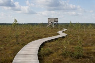
The official trail description associates the present route with an old road connecting now-vanished wetland villages in the eighteenth century. This opens another line of inquiry: everyday links between settlements, peat work and farming beside the bog.
Aukštumala's history should not be recast as a secret military road simply because the description uses the term kūlgrinda. A shared term does not erase different local histories.
What a modern visitor trail represents
A visitor trail helps interpret a landscape, but its surface, precise alignment and stopping places are not automatically replicas of the historical construction. Read the current trail description separately from the account of the old road.
A ford or submerged stretch mentioned in a historical text is not a verified present-day crossing. For a visit, use the official route and its latest condition information.
Four questions for an old road
When was it first described? Was its construction dated by investigation or merely proposed? Which specific places did it connect? Which part of today's landscape is confirmed as the historical route?
Keep answers alongside the source and its date. An unknown construction date is more accurate than a century selected to fit an attractive story.