- Category
- Reading the landscape
- Reading time
- 3 min.
- Sources
- Local history interpreted from cited sources
A polder is a system, not just a dyke
A polder is an area separated from surrounding waters by dykes, with a managed water regime. The dyke alone cannot remove water collected inside: drains, collection channels, outlets and, where necessary, pumps also matter. Read the landscape by following the whole water pathway.
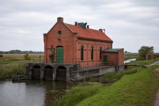
Ask not only where the pumping station stands, but which land drains into it and where the water goes. A historic pumping-station building represents one part of that system.
Summer and winter polders
The polder study published by Lithuania's Fisheries Service distinguishes summer and winter polders. Summer polders protect land during the growing season and may be inundated during a high spring flood; winter polders are designed for protection throughout the year. This is a difference in design purpose, not a guarantee against every flood.
The names are not recommendations about visiting seasons. Present conditions depend on water levels and the state of the system, neither of which is established by a historical account.
1840 and 1888: a dyke and a breach
The study's historical review mentions a Rusnė dyke in 1840 and its breach due to an ice jam in the Atmata in 1888. Water-management history includes failure and repair as well as construction.
A present-day embankment should not be assumed to retain its entire original fabric. Its structural history requires records for the particular stretch.
1904–1907: a stage in Uostadvaris's development
The study dates the start of the first summer polder on Rusnė Island to 1904 and completion of its first pumping station to 1907. The area later became known as Uostadvaris Polder. Retain both dates: the start of work and completion of an installation are different events.
Uostadvaris water-lifting station connects industrial heritage with the surrounding landscape. Display of historic machinery does not itself identify which pumps manage the water today.
Recording what you see
From a publicly accessible viewpoint, identify the dyke, drain, building and visible direction of flow. Separate connections confirmed by an information panel or plan from those you merely infer. A photograph of the water surface cannot establish whether a pump is operating.
The cited study supports principles and historical context. Its contemporary condition assessments, costs and operating data are not a check of this year's system; current decisions require current information from the responsible operator.