- Place
- Mažeikiai District Municipality
- Region
- Žemaitija
- Type
- a timber viewing deck on the Venta riverside walking route
- Address
- beside the stadium of Mažeikiai Ventos Progymnasium, Mažeikiai
- Coordinates
- 56.29812, 22.33099
- Visit duration
- 20-45 minutes; longer when walking the Venta riverside route
- Best time
- year-round; the river is clearer after leaf fall, while a dry day makes the path more comfortable
Ventos River Viewpoint, Venta Valley Lookout, Ventos slėnio apžvalgos aikštelė
Where the viewpoint actually is
Venta Valley Viewpoint stands in Mažeikiai on the steep right bank of the Venta, beside the stadium of Ventos Progymnasium. The municipality identified this landmark clearly in April 2025 when describing a riverside clean-up from the Ąžuolas allotment association to the viewpoint next to the stadium. Pavenčių Street 15 is the school's address and a useful nearby landmark, not a separate street number assigned to the deck.
The coordinates on this page mark the viewing deck itself rather than the whole Venta Valley recreation area. It is in the town of Mažeikiai and should not be confused with Venta Regional Park, which covers a different reach of the river around Papilė and the wider Viekšniai area.
The final approach is best made on foot along the paved riverside path. Navigate to the precise viewpoint pin, do not drive into school or stadium service approaches, and follow all current local signs.
A timber deck rather than a tower
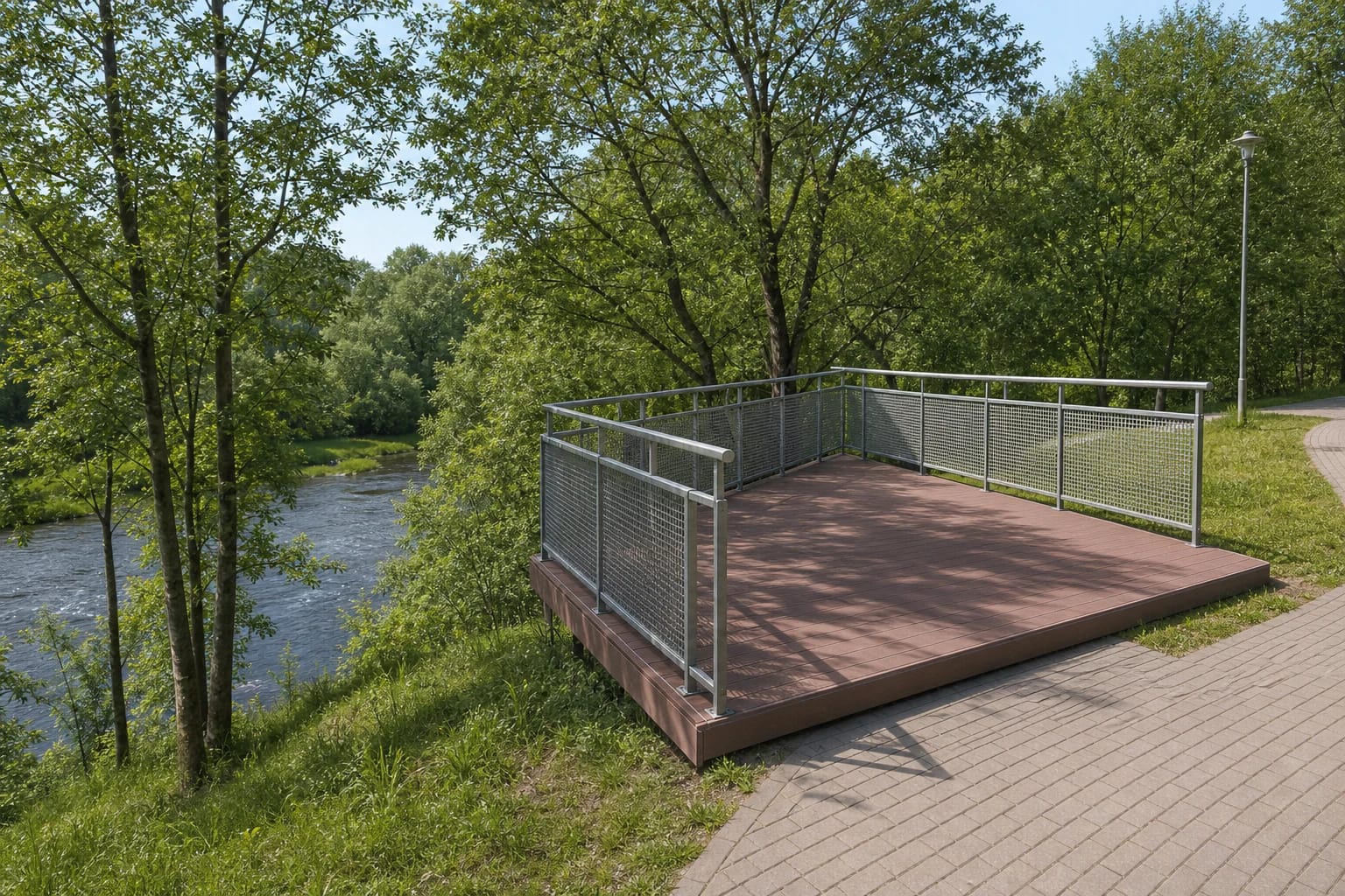
Official municipality photographs from 2025 show a broad reddish-brown timber deck set above a slope thick with trees and shrubs. Silver-coloured metal mesh railings separate visitors from the steep edge, while the platform connects directly to a grey block-paved path with lighting.
This is a low viewing deck, not a tower reached by stairs. The Venta flows below, but foliage screens part of the water and the farther valley. In summer the place feels like a green balcony above the river; in late autumn, winter, and early spring, the channel is easier to read through bare branches.
The view is not a limitless panorama. Its value lies in the close relationship between the steep slope, riverside trees, and water below. Photographs work best when they use the line of the railing, the path, and reflections on the Venta rather than expecting a high urban skyline.
How the valley became an urban recreation space
An earlier EU-funded improvement project covered 200,052.55 square metres of public space in the Venta River Valley. Project activity ended in late 2019 and the contract period closed in March 2020. Its aim was to turn a neglected section of the town's valley into a recreation and active-leisure area.
Across the whole project area, walking and cycling routes, lighting, a pier, beach and rest facilities, sports and play spaces, a campsite, information features, and a viewpoint were created or renewed. This is a valley-wide inventory - visitors should not expect every facility to stand beside this one deck.
The viewpoint works best as a brief stop on a longer riverside walk. Anyone wanting to explore more of the improved valley should choose a route start and finish in advance, since the platform itself does not take long to visit.
The Venta and a changing riverside
The Venta is 343 kilometres long, including 163.9 kilometres in Lithuania. It passes through Papilė, Viekšniai, and Mažeikiai, continues across Latvia, and reaches the Baltic Sea at Ventspils. The Mažeikiai viewpoint reveals only one urban cross-section of that much larger river from the top of its bank.
At the end of 2025, the municipality announced another visitor-access stage for the wider Mažeikiai section of the valley, scheduled through August 2029. Parking, sanitation, small architectural features, rest platforms, and information facilities are planned across the project area. The announcement does not prove that this exact deck will be rebuilt or that every work site is beside it.
As work proceeds in stages, some riverside sections, approaches, or amenities may change temporarily. Check recent municipality notices before a longer walk and respect barriers and temporary signs on site.
Visit length, accessibility, and safety
Allow about 20-45 minutes for the viewpoint and its immediate view. No separate ticket office, admission charge, or museum-style opening hours are stated in the checked official sources; temporary closure for maintenance, weather, or valley works is still possible, so check municipality updates before a special journey.
Official photographs show a stair-free entrance to the deck from the upper block-paved path. No formal accessibility audit for the complete approach was found, however, so a suitable gradient, kerbs, and an uninterrupted comfortable surface cannot be guaranteed for visitors with limited mobility.
Leave a car only in a currently marked public space and never block school, stadium, or maintenance access. Move carefully when the deck or path is wet, stay behind the railings, and keep children close beside the steep slope.