Uostadvaris village, Rusnė Eldership, Šilutė District Municipality
Pamarys
historic Nemunas Delta lighthouse and viewpoint
Uostadvario g. 47, Uostadvario k., Rusnės sen., Šilutės r.
55.34400, 21.29100
30-60 minutes; longer with the water-lifting station and Rusnė
a calm summer or early autumn day, when Nemunas Delta roads are dry
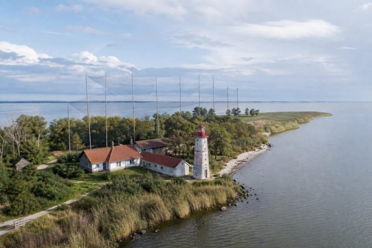
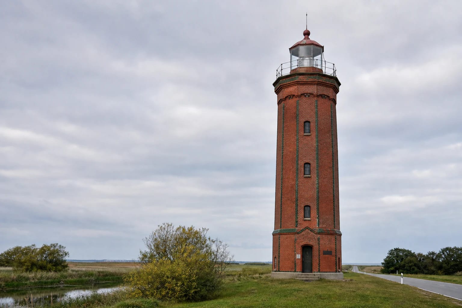
Uostadvaris lighthouse tower
Uostadvaris Lighthouse: a Nemunas Delta tower
Uostadvaris Lighthouse stands in the landscape of Rusnė Island, where water, polders, channels, and roads constantly remind visitors that the Pamarys region lives by a different rhythm from higher parts of Lithuania. The lighthouse here is not a decoration of maritime romance; it is connected with delta orientation, waterway history, and technical heritage.
In the Register of Cultural Values, the object is listed at Uostadvario g. 47 in Uostadvaris village, Rusnė Eldership. Its KVR code is 16800; it is state protected and of regional significance.
Octagonal red-brick tower built in 1873-1876
According to KVR and protected-area data, Uostadvaris Lighthouse was built in 1873-1876 on the left bank of the Atmata, opposite the mouth of the Minija. It is 18 m high, regular octagonal in form, built of red brick, with edges decorated in green glazed bricks. In the landscape it stands out not by height but by a clear, decorative silhouette.
Inside are 48 spiral concrete steps leading to the lantern room and a viewing platform with metal railings. A wooden keeper's house once stood beside the lighthouse, connected by an entry porch; in the late twentieth century it was rebuilt in masonry. In 1996 the lighthouse was declared a cultural monument, and in 2003 it even appeared on a Lithuanian postage stamp. Although no longer used for navigation, its position still explains why landmarks were necessary in this part of the delta.
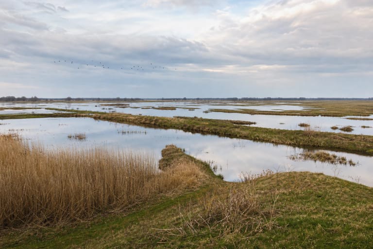
Pakalnė polder landscape
Saugoma.lt links this place with the Pakalnė Polder Landscape Reserve. That matters because the lighthouse is best understood not separately but together with the polders, channels, and water-regulation infrastructure.
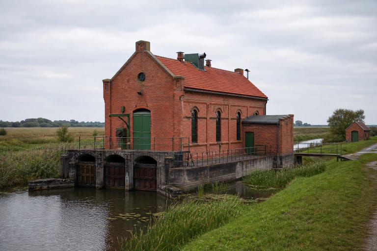
To visitors the polder landscape may look flat and empty, but it contains much engineering: water is redirected, roads and homesteads depend on embankments, and Uostadvaris Lighthouse and the water-lifting station tell the same story of human adaptation to the delta.
Why the lighthouse is visited today
Because the lighthouse is no longer used for navigation, its value today is more cultural and landscape-based. Visitors come for the red-brick tower, views over the delta, the neighbouring Uostadvaris Water-Lifting Station, and the atmosphere of Rusnė Island.
It is a good stop when travelling through Rusnė: the place is not large, but it joins technical heritage, nature, and regional water history in a short visit.
How to plan a visit
Allow 30-60 minutes for Uostadvaris Lighthouse. Combine it with the nearby Uostadvaris Water-Lifting Station, Rusnė town, the Pakalnė polders, and the wider Nemunas Delta route.
Verified official KVR and protected-area sources do not list permanent opening hours or tickets. Before travelling, check local information and weather conditions, especially in spring or after heavy rain, when Nemunas Delta roads and access can be more sensitive to water.