- Place
- Rudamina, Lazdijai eldership, Lazdijai District Municipality
- Region
- Dzūkija
- Type
- the hillfort component of a nationally significant archaeological complex, with a ring bank, 25-metre slopes, and a separately registered foot settlement
- Address
- Piliakalnio Street, Rudamina village, Lazdijai eldership, Lazdijai District
- Coordinates
- 54.28208, 23.44135
- Visit duration
- 45-75 minutes for the ascent, the 75 by 51 metre enclosure, the ring bank, and contrasting sides of the foot
- Best time
- a dry day in spring or early autumn, when the grass is low, foliage obscures less of the bank's profile, and the northern steps are not slippery
Rudaminos piliakalnis, Beviršiai Hillfort, Rudamina Hillfort with Settlement
An isolated hill in wet meadows, with a 75 by 51 metre enclosure inside a ring bank
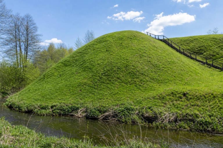
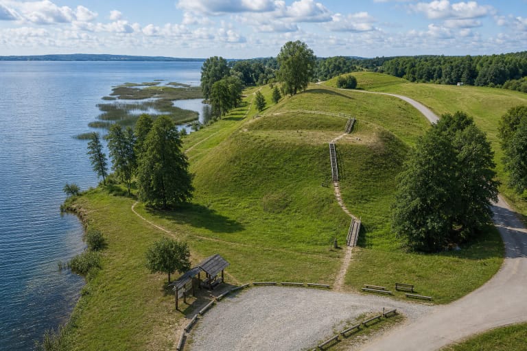
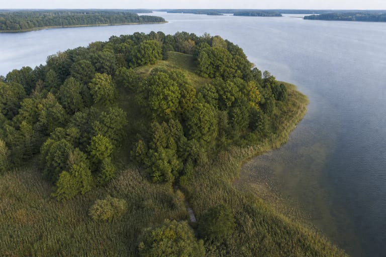
Rudamina Hillfort was established on a large isolated hill about one kilometre south of Rudamina. The Cultural Heritage Register describes high ground surrounded by wet meadows, while its photographs from 2005 and 2019 show a broad grassy cone crowned by a fringe of trees. This is neither a lakeside promontory nor a reconstructed timber castle: the earthwork itself is the principal thing to see.
The oval enclosure runs north to south and measures 75 by 51 metres. Its western and northern edges sit slightly lower. A bank encircles the entire interior, rising 2-3 metres above it and spreading 10-16 metres wide; its steep outer face is 5-8 metres high. On the western and northern sides, the bank was built lower down the natural slope, making the ring appear even more massive from outside. The natural hill slopes are steep and about 25 metres high.
Most of the hill is rough grassland. In 2019, the register recorded lime trees along the bank, trees and scrub on the southern and south-western slopes, and a former orchard at the north-eastern foot. Vegetation changes how much of the earthwork can be read, so the bank's geometry is clearest when the enclosure edge and several sides of the foot are viewed in turn, without searching for masonry or rebuilt walls.
Complex 22941, hillfort 5308, and settlement 22942 do not share one undifferentiated list of finds
The Cultural Heritage Register protects the whole site as Rudamina Hillfort with Settlement, code 22941. It is a nationally significant monument with a registered area of 216,710 square metres. The complex has two archaeological components: the hillfort itself, code 5308, and its foot settlement, code 22942. These numbers do not identify three separate visitor destinations; they distinguish the whole protected place from its two constituent evidence sets.
Hillfort component 5308 contains the oval enclosure, ring bank, steep slopes, and the areas examined in the enclosure and bank in 1965. Settlement component 22942 extends around the southern, south-western, western, and north-eastern foot, where pottery was found in a cultural deposit. Sherds recovered below the hill must not be silently transferred into the artefact list from the summit excavations.
The current register dates the complex and both components to the 5th-14th centuries. VLE's Rudamina Hillfort article gives the narrower 5th-13th-century summary. Because the ranges are not identical, this page follows the current register while stating VLE's version explicitly. Neither range alone proves a castle belonging to a named ruler or an event dated to a specific year.
The 1965 section revealed four phases of the bank and evidence of a severe assault
In 1918, a German army officer attempted excavation on the north-eastern and north-western edges of the enclosure and recovered assorted finds. The principal archaeological investigation, however, was led by Pranas Kulikauskas in 1965. A total of 320 square metres was examined across the enclosure and a section through the northern bank. The cultural deposit varied from 0.4 to 2 metres deep.
The excavation found hearths, animal bones, charred grain, handmade rough-surfaced pottery, and wheel-thrown pottery. Metal and glass finds included iron socketed and tanged arrowheads, a bronze ladder brooch, spiral rings, a pendant, a belt buckle, and a glass bead. VLE states that the finds are held by the National Museum of Lithuania; there is no museum display on the hill itself.
The section through the northern bank showed four phases of construction and reinforcement. During the third phase of the stronghold, timber defences burned in a severe assault, and arrowheads recovered outside the bank attest to bow fire. The bank was subsequently raised by about another metre. Archaeology confirms burning, attack, and rebuilding here, but does not by itself name the attackers or any historical individual.
Pottery and later test trenches at the foot belong to a separate settlement component
In settlement component 22942, the register protects a dark cultural deposit containing finds. A 1962 survey recovered handmade pottery with smooth and rough surfaces, as well as wheel-thrown pottery, from the southern and other parts of the foot. VLE summarises the foot settlement as covering about four hectares, but this is not the same measurement as the 21.671-hectare registered area of the entire complex.
In 2003, 13 square metres were tested at the northern foot, followed in 2007 by seven square metres on the northern slope. No cultural deposit or finds were encountered in those particular small areas. That result does not erase the settlement documented elsewhere around the hill: it shows that the deposit is uneven and that not every part of the slope was occupied.
The register records long-term ploughing across the settlement and a former orchard at the north-eastern foot. Visitors will not see its boundary as another bank or a marked village. Its archaeological evidence lies below what appears to be ordinary meadow, so digging, metal detecting, collecting finds, and driving across the protected area are inappropriate.
Ringaudas, Mindaugas's coronation, and a bombard in 1381 belong to a history of older claims
The historical note in the register documents a tradition of interpretation created by older authors. Beginning with Teodor Narbutt and repeated later by Jonas Basanavičius and Jonas Totoraitis, writers claimed that Ringaudas built a castle here in 1240, that Mindaugas was crowned in it, and that bombards using gunpowder destroyed the stronghold in 1381. The register records the history of these statements, but they are not a verified chronicle of events on the site.
Reliable archaeological evidence demonstrates the long 5th-14th-century development of the complex, repeated reconstruction of the bank, fire, and an assault with arrows. It does not establish Ringaudas's construction date, a coronation place for Mindaugas, or the bombard episode of 1381. The precise conclusion is that Rudamina is linked to Mindaugas in local memory and older historiography, not that his coronation here is an established fact.
The tradition remains culturally active. Lazdijai District Municipality says that the Statehood Day commemoration at the foot of Rudamina Hillfort has become an annual event, and the municipality itself calls the Mindaugas connection a legend. The celebration explains why the hill matters today, but its programme and symbolic return of the king are not archaeological proof of the story.
Molotov Line works damaged the bank in 1941, and no official visiting schedule is published
The bank was damaged in 1941 during work on the Soviet Union's Molotov defensive line. Two large pits were dug in the bank for permanent machine-gun firing positions, the northern bank was cut through to create an entrance, and trenches disturbed the earthwork elsewhere. This is more exact than saying simply that bunkers stood on the hill: the register specifically documents emplacement pits, the cut, and trench damage.
In 2019, the register recorded a parking area at the northern foot, terraced steps ascending the northern slope, benches in the enclosure, and a stone fire ring. This is an observation from a stated year, not a guarantee that every feature remains unchanged or is regularly maintained. The 25-metre slopes, uneven grass, and steps do not form a confirmed step-free route and can be slippery after rain.
The exact Google Maps place marks 54.2820826, 23.4413528. Visitor information and opening-hour fields in the register are blank, and the official sources checked do not publish a ticket office, admission charge, gate, or fixed schedule. Visit in daylight, park only where current signs permit, and check Lazdijai District information before travelling. On 15 July 2026, place ID ChIJ3Zuyizbd4EYRJSlevPrrqO4 showed 4.8 out of 5 from 188 reviews; both figures can change over time.