- Place
- Paveisininkai village, Lazdijai District Municipality
- Region
- Dzūkija
- Type
- a monument-status archaeological complex comprising a hillfort, settlement around its foot, and an earlier cremation cemetery
- Address
- Paveisininkai village, Kapčiamiestis eldership, Lazdijai District, southern shore of Lake Veisiejis
- Coordinates
- 54.07508, 23.60703
- Visit duration
- 60-120 minutes for the archaeological complex, excluding a potentially long walk from a safe place to leave a car
- Best time
- dry daylight conditions only after checking the present state of the footbridge, paths, and steps; the marshy approach can be unsafe after rain or snowmelt
Paveisininkų piliakalnis, Paveisininkai Hillfort and Settlement, Paveisininkų piliakalnis su gyvenviete
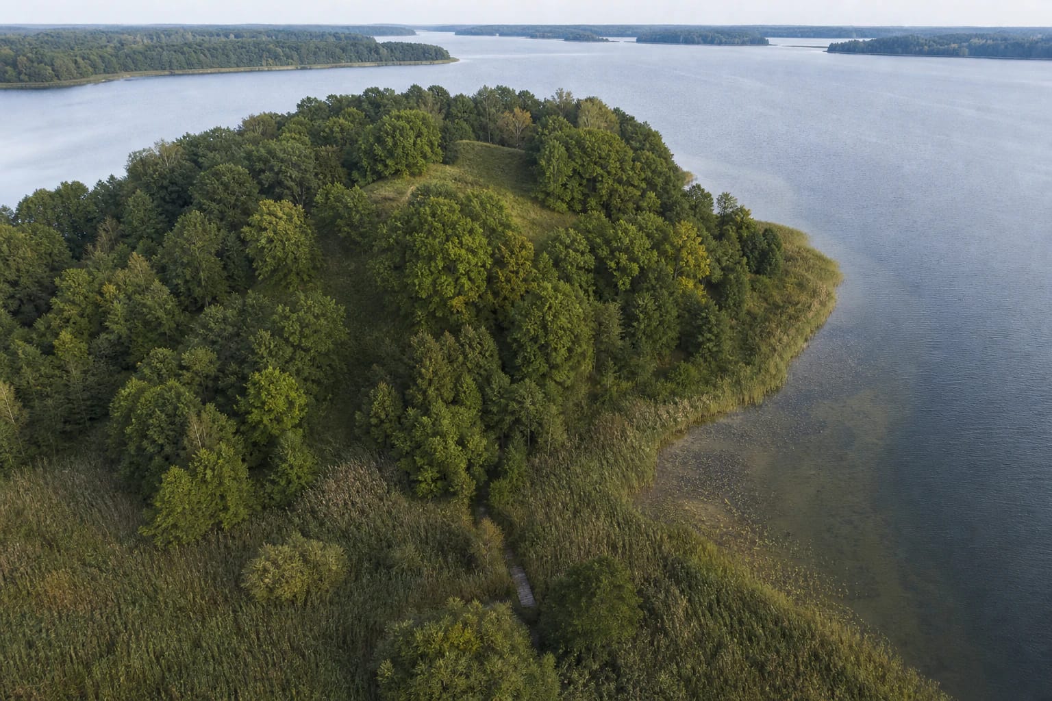
Lake Veisiejis and a marsh turned the hill into an almost isolated peninsula
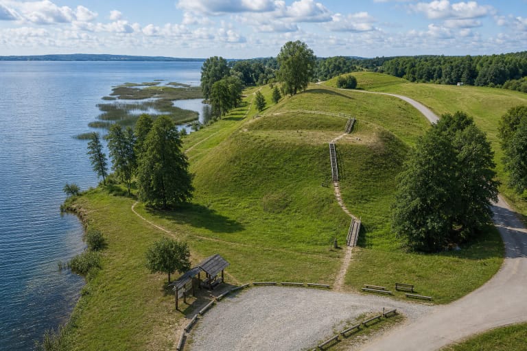
Paveisininkai Hillfort lies in Kapčiamiestis eldership, about two kilometres north of Paveisininkai village on the southern shore of Lake Veisiejis. It occupies the southwestern part of a detached hill. Raising the lake level surrounded most of the landform with water, leaving a marshy connection to dry ground in the south. The peninsula seen today therefore combines natural relief with a human-altered water level.
Published measurements of the oval east-to-west summit vary between roughly 24-30 by 25-30 metres. A bank 1-3 metres high and 8-16 metres wide encircles it. The main slopes rise around 20 metres, with the upper fortified part adding another 4-5 metres. Trees and undergrowth conceal some of this shape, so visitors should look for lines of banks, terraces, and ditches rather than masonry.
The outer face of the eastern bank drops to a terrace. Beyond it lie a ditch about seven metres wide and 1.2 metres deep, a second bank roughly five metres wide, and another ditch 5.5 metres wide and one metre deep. Traces of banks and ditches also survive on the western side. This sequence of obstacles demonstrates deliberate defence, although no written source names a particular castle that stood here.
Archaeologists found an earlier cemetery of 27 cremation graves beneath the fortified summit
In 1962 an expedition led by Pranas Kulikauskas excavated 240 square metres in the northeastern part of the summit and cut through the bank in two places. The sections showed that the first bank stood about 1.6 metres high and was paved with stone along its top. It was later raised and reinforced externally with clay and stone, with a defensive wall of earthfast timber posts erected above it.
Within the summit's cultural deposit, which reached one metre thick, archaeologists found 27 cremation graves. VLE dates the cemetery to the third or fourth century AD and explicitly states that it predates the hillfort. This sequence is invisible to an unprepared visitor: the hill was first used to bury the dead and only later reshaped for defence.
Burial practice was not uniform. Cremated bones were placed in small pits, deposited in urns, or laid on stones and covered by further stones. No grave goods were found, so the burials cannot honestly be turned into stories about named warriors or individuals. VLE dates the hillfort broadly from the first millennium to the thirteenth century, but this does not prove that one fortification operated continuously for all those centuries.
The settlement below preserves evidence of houses, household life, and contact with the Roman world
A settlement covering about 1.5 hectares has been identified at the eastern, northeastern, and western foot of the hill. Pranas Kulikauskas in 1962 and Vygandas Juodagalvis in 1992 excavated a combined 314 square metres. The cultural deposit, up to 60 centimetres thick, contained hearths, postholes from timber structures, and storage pits, documenting everyday life outside the upper enclosure.
Finds include a bronze bow brooch, a bracelet, a Roman coin, animal bones, and handmade pottery with brushed, smooth, and roughened surfaces. A single Roman coin does not mean Romans lived here. It records the long journey of an object or exchange connections reaching the Baltic region, while the three pottery traditions help archaeologists distinguish different periods of activity. The finds are held by the National Museum of Lithuania.
The Cultural Heritage Register separates the legal structure of the protected site. Code 22931 covers the hillfort and settlement complex, code 5294 identifies the hillfort component, and code 22932 identifies the settlement component. The whole complex has monument status. These numbers matter because a database search can show all three records and make them look like three separate visitor attractions.
People lived around Lake Veisiejis much earlier, but no named Yotvingian castle is confirmed
A Lithuanian Institute of History study of the first Zapsė River settlement places the Paveisininkai excavations within the much longer prehistory of Lake Veisiejis. Swiderian flint arrowheads were found in the hillfort settlement area in 1962, and Stone Age sites were identified nearby. Later work on the opposite shore revealed Mesolithic, Neolithic, and Bronze Age findspots.
This early evidence explains why the Veisiejai area is understood as a lake landscape occupied over a very long period, but it should not be collapsed into the much later defensive phase of the hillfort. The same useful relationship between water and dry ground drew people in different eras, when their tools, lifeways, and burial customs had already changed.
The protected-areas directorate places Veisiejai within the wider legacy of the Yotvingians, and the hillfort's broad chronology overlaps with their history in southern Lithuania. Archaeology nevertheless provides no ruler, castle name, or recorded battle for Paveisininkai. It is accurate to explain the Yotvingian regional context, but not to invent a named fortress.
Check whether the paths and steps have actually been rebuilt before travelling
The map pin at 54.075079, 23.607027 marks the archaeological site itself, not a confirmed car park or safe entrance. Older directions turn from the Veisiejai-Kapčiamiestis road near Navikai towards Paveisininkai, then head north from the first farmsteads towards Lake Veisiejis. They do not account for current road condition, private plots, barriers, or the marshy final approach. Follow local signs and never block access for residents.
A condition report published on 13 July 2025 described a very poor road, a walk of several kilometres for groups arriving by bus, and unsafe damage to the marsh footbridge and some steps. The Lazdijai District Municipality's 2025-2027 measures plan schedules reconstruction of the Lake Veisiejis jetty, paths, and hillfort steps, plus landscaping, within a wider project running in 2024-2028. A planned project is not proof that work has been completed.
No official notice confirming completion of the whole access route was found by 15 July 2026. Ask Veisiejai Regional Park or a Lazdijai District information service for the latest condition before setting out. Do not use unstable steps, attempt to cross water or marsh away from a marked route, or continue when access is closed. The place is not adapted for visitors with reduced mobility.
Official heritage records publish no admission charge, gate, or opening hours, but that does not mean the site is always safely accessible. If the route is open and in good condition, allow 60-120 minutes for the complex plus extra walking time. On 15 July 2026, the exact Google Maps listing averaged 4.6 out of 5 from 15 reviews. It clears the 4.5 threshold, but the small sample means the score can change quickly.