- Place
- Kaukai and Remeikiai, Miroslavas eldership, Alytus District Municipality
- Region
- Dzūkija
- Type
- a state-protected, multi-period Kaukai-Obelytė archaeological landscape with 8-9-metre slopes, three phases of bank construction, an extensive foot settlement, and an exceptional arrowhead assemblage
- Address
- Sodų Street, Kaukai II village, Miroslavas eldership, Alytus District; the heritage register uses Remeikiai village
- Coordinates
- 54.35223, 23.78428
- Visit duration
- 45-75 minutes for Kaukai Hillfort, its earthworks, and the Peršėkė bank; plan a longer look at the Kaukai-Obelytė landscape only after checking current access across the stream
- Best time
- a dry, clear day from April to October; the earthworks read especially well in early spring and late autumn, while the field road, grass, and steps can be slippery after rain
Kaukų piliakalnis, Kaukų piliakalnis su gyvenviete, Kaukai and Obelytė hillforts, Kaukai-Obelytė archaeological complex
A local road and southern steps lead to the hill, but work scheduled for 2025-2027 may alter access
The precise Kaukai Hillfort pin is 54.352230, 23.784284. Visitor information places it on Sodų Street in Kaukai II, while the Cultural Heritage Register now assigns the protected parcel to Remeikiai village. Both identify the same hillfort on the left bank of the Peršėkė, not two places with one name. An older approach turns northeast off the Kumečiai-Parėčėnai road before Parėčėnai and follows a field road for roughly 400 metres. Navigate to the exact pin, do not cross crops, and never park where a local road is blocked.
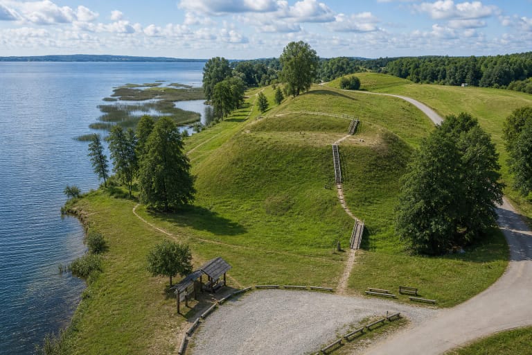
Timber steps climb the southern slope, but no level, step-free route to the enclosure has been confirmed. Rain can soften the field road and make the 8-9-metre slope, grass, and treads slippery. The present climb may be unsuitable for a wheelchair, reduced mobility, or a pushchair. Visit in daylight, wear shoes with reliable grip, and stay on the established approach instead of cutting into the archaeological slope.
Alytus District Municipality is running the Land of the Mysterious Yotvingian Tribe project from July 2025 to June 2027. Plans for Kaukai include three small bridges, stairs, a path, an approach road, and selective removal of woody growth. In July 2026 this remains an active project, not completed infrastructure. Check municipal notices before travelling for current works, traffic restrictions, and the actual condition of the route.
Kaukai and Obelytė are separate defended sites on opposite banks of the Peršėkė but belong to one landscape
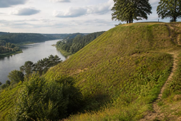
Kaukai Hillfort was built on a spur in a bend of the Peršėkė's left bank. The stream encloses it from the east, north, and northwest, while the hill joins higher ground to the south. The oval north-south enclosure measures 25 by 16 metres in the heritage register; VLE rounds it to 27 by 17 metres. A bank encircles the enclosure and rises at the southern end to five metres high and 14 metres wide. Beyond it lies a ditch 12 metres wide and 1.5 metres deep. The natural slopes are steep and rise roughly 8-9 metres.
Across the Peršėkė, on a corner of the right-bank upland, stands the separate Obelytė Hillfort, also known as Nugara or Zomkus, with an outer enclosure. The stream has washed away most of its enclosure and slopes, and ploughing, pits, and farm activity disturbed what remains. Kaukai therefore appears as a compact green defensive mound, whereas the earthwork at Obelytė is much harder to read. The heritage register treats them as two complexes, codes 22611 and 22613.
A foot settlement extends over the upland south and southeast of Kaukai. The registered Kaukai complex covers approximately 5.4 hectares and the Obelytė complex about 3.44 hectares, but these administrative protection areas are not identical to settlement extents estimated in different archaeological publications. Protection does not stop at the summit: cultural deposits continue beneath meadow that may look archaeologically empty.
Excavations in 1967-1969 uncovered pavements, hearths, postholes, and three phases of bank construction
Vilnius University archaeologists led by Pranas Kulikauskas excavated Kaukai in 1967-1969. Summaries usually list 250 square metres in the western enclosure and an 80-square-metre section through the bank and ditch, while a recent reassessment totals all trenches at 382 square metres. That is a substantial excavation, but still only part of the monument.
The cultural layer was generally up to one metre thick and reached 2-2.3 metres inside cut features. It contained five or six successive levels of stone paving, hearths, postholes, storage pits, burnt timbers, and clay. The bank section revealed at least three episodes of reinforcement using stone, rammed clay, and timber structures. This stratigraphy belongs to a repeatedly rebuilt residential and defensive place, not a single short-lived camp.
More than 1,500 pottery sherds were retained, including handmade roughened, pinched, and smooth wares as well as wheel-finished pottery. Finds also included charred pulses, animal and occasional human bones, evidence of spinning and weaving, tools, jewellery, and weapons. VLE summarises the metal assemblage as roughly 500 objects. They are held by the National Museum of Lithuania; there is no finds exhibition at the hillfort itself.
The 126 arrowheads prove a major attack, but they do not name the attacking force
The excavated assemblage contains 126 arrowheads, a figure VLE rounds to about 120. Many occurred with a burnt layer and other objects dating from the late tenth to early eleventh century. The group includes 23 tanged, lanceolate arrowheads of Scandinavian or Scandinavian-related form and two fork-shaped examples. Such an unusually concentrated group is strong archaeological evidence of a violent assault rather than the peaceful storage of weapons.
A late tenth-century heraldic pendant from the site bears symbolism comparable to signs associated with the Kyivan prince Yaropolk Sviatoslavych, who ruled in 972-978. The arrowhead types, fire, and pendant encouraged an older narrative that Kyivan Rus destroyed Kaukai in the eleventh century. Archaeology supports the approximate date of an attack, but no written source names this campaign, commander, or attacking army. A Kyivan Rus assault is a reasoned hypothesis, not a settled identification.
Crucially, the burnt horizon may not mark the site's final end. A recent reassessment of the wheel-finished pottery distinguishes at least four phases of occupation and identifies later ceramic technology above the attack layer. A single ring possibly dating between the thirteenth and early fifteenth centuries, together with the pottery sequence, supports a hypothesis that Kaukai was rebuilt and abandoned only in the later thirteenth century. Later ploughing and the recording standards of an older excavation mixed deposits, so the final date remains open to debate.
The Yotvingian interpretation is meaningful, but pottery alone cannot draw an ethnic frontier
Kaukai is often presented as one of the most important Yotvingian hillforts in southern Lithuania. Its position in a region inhabited by western Baltic Yotvingian communities, the scale of the defences, and its later occupation phases support that association. Material from Kaukai genuinely matters to discussions of the northern and northeastern Yotvingian world and its contacts with neighbouring societies.
Archaeologists nevertheless continue to debate exactly where that ethnic boundary lay. Kaukai's wheel-finished pottery has local traits but also shows influences from western and eastern Slavic potting traditions. Techniques can travel through trade, marriage, and mobile craftspeople, so they do not automatically assign inhabitants to another ethnic group. Yotvingian-region complex or site associated with the Yotvingians is more honest than claiming the known name and population of a particular tribal castle.
Local tradition says that a church sank into the hill and its bells could be heard underground during Sunday Mass. Another legend preserved in the heritage record tells of a chain protruding from the eastern slope and of the hill swallowing people who tried to pull it free. These stories belong to local memory and explain why the striking landform felt mysterious; they are not evidence for the site's date or a particular historical event.
An open grassy profile reveals the defences, while a high visitor score does not replace practical preparation
Kaukai's impact comes from a legible earthwork rather than a wide panorama or reconstructed castle. From the foot, visitors can see the tall green bank, southern ditch, narrow Peršėkė, and timber access, while the summit enclosure is compact. Read the changing height of the slope from established routes around the foot instead of looking for masonry or climbing straight up the turf.
Long-term ploughing lowered the bank, damaged the enclosure, and mixed upper deposits, while the Peršėkė removed most of Obelytė. Do not dig, use a metal detector, pull stones from the slope, light a fire, or drive onto the protected ground. Archaeological information left in context beneath the soil matters more than an isolated object removed from it.
Official sources list no ticket office, admission charge, gate, or fixed opening hours, so this is a self-guided outdoor site. Travel by daylight and check official project notices first. On 15 July 2026, the latest publicly indexed figure for the exact Google Maps place was 4.7 out of 5 from 50 reviews. That clears the 4.5 threshold, but the score can change and says nothing about a muddy approach or whether new paths are complete.