- Place
- Alytus, Alytus City Municipality
- Region
- Dzūkija
- Type
- a nationally significant hillfort and second-to-fifth-century foot settlement in Vidzgiris Botanical Reserve, reached on a forest nature trail
- Address
- Vidzgiris Botanical Reserve, Alytus; loop-trail car park at 54.380301, 24.008476
- Coordinates
- 54.37430, 24.00530
- Visit duration
- 1.5-2.5 hours for the roughly 4-kilometre forest loop and hillfort; a shorter visit is possible by returning along the same route from the hill
- Best time
- a dry day from April to October; the bank, ditch, and Nemunas valley read best before leaves emerge in early spring or after they fall, but wet steps and the Kirmija bank can be slippery
Radžiūnų piliakalnis, Radžiūnų I piliakalnis, Pilaitė, Alytus II Hillfort
Google Maps' Radžiūnai I Hillfort is the long-known Pilaitė, not either of the two more recently identified forest sites
The hillfort covered here is precisely at 54.374300, 24.005300. Google Maps calls it Radžiūnų I piliakalnis, while the Cultural Heritage Register assigns code 22601 to the complete hillfort and settlement complex. The hillfort itself is component 1850 and the foot settlement component 22602. The older names Pilaitė and Alytus II Hillfort identify this same place, so the word second in the latter does not mean the nearby Radžiūnai II Hillfort.
Vidzgiris Forest contains two other defended sites, currently registered as Radžiūnai II and Radžiūnai III Hillforts under codes 41155 and 41153. They stand several hundred metres from the principal monument, remain wooded, and do not share its visitor route. A short name can therefore lead navigation to the wrong earthwork. Use the Google place with 80 reviews or the coordinates on this page.
The principal Radžiūnai complex has been a state-protected archaeological monument of national significance since 1998. That distinction sets the expectations for a visit: this is neither a reconstructed castle nor an attraction park, but protected terrain whose value survives in its bank, ditch, slopes, and cultural deposits below ground.
The Nemunas and Kirmija valleys created 30-35-metre slopes, while people fortified the one easier northern approach
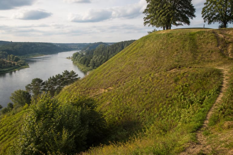
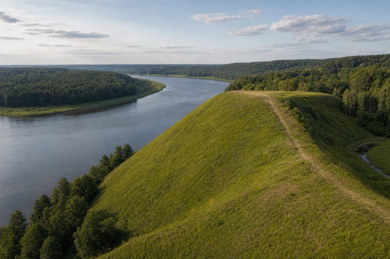
The hillfort occupies a promontory on the left side of the Nemunas beside the Kirmija stream. The deep Kirmija ravine protects the west, the Nemunas valley drops away to the south and east, and the spur joins the upland only in the north. Trees now conceal much of this form, but its steep 30-35-metre slopes explain why the position could be difficult to reach.
The triangular enclosure measures approximately 40 by 40 metres. Along its northern edge is a bank about 40 metres long, four metres high, and 17 metres wide; the bank's outer face descends into a ditch 12 metres wide and 2.2 metres deep. This is the clearest defensive sector because it blocked the naturally easiest route from the upland. To the southwest, the bank is lower and merges into the edge of the spur.
A broad valley bench separates the eastern side of the hillfort from the present Nemunas channel. The summit does not always deliver an open river view comparable to Punia: foliage, trees on the slope, and water level all change the outlook. In the leafless season, both the Nemunas direction and the way the Kirmija ravine isolates the western side become much easier to read.
The second-to-fifth-century settlement predates possible late use of the hillfort and does not identify a named castle
VLE dates the hillfort from the middle of the first millennium to the beginning of the second, while dating the settlement at its foot to the second-fifth centuries. These ranges describe different phases of use. An early settlement layer does not prove that all visible defences were built at once, and the broad span assigned to the hillfort does not by itself identify a castle recorded in thirteenth-century written sources.
An expedition led by Zenonas Baubonis in 2002 found a cultural layer up to 53 centimetres thick in the settlement. Finds included traces of a hearth, an iron spearhead, flint cores and flakes, sherds of smooth and rough pottery, and animal bone. The assemblage records everyday work, cooking, tools, and weaponry, but only a small part of the settlement has been excavated. Its complete plan and population cannot be reconstructed.
A municipal account preserves a legend that two princely brothers built up the hill for defence. It belongs to local memory, not archaeological proof: the brothers' names, period, and the historical name of a castle here are unknown. Radžiūnai already has a compelling real landscape and excavated evidence, so the legend need not be turned into a documented event.
The hillfort is stop twelve on the Vidzgiris trail, where archaeology meets hornbeam woods, springs, and the Kirmija ravine
Vidzgiris Forest covers roughly 452 hectares within Alytus, while the State Service for Protected Areas gives the formal botanical reserve an area of 387 hectares. The reserve was established in 1960 to conserve a natural southern Lithuanian forest complex in the Nemunas valley and habitats of rare plants. The figures are not contradictory: the larger describes the forest as a whole and the smaller the protected area.
The reserve protects broadleaf and mixed woods, hornbeam stands, ravine and slope forests, dry oak woods, alluvial forest, and tufa-forming springs. Alytus Municipality describes Vidzgiris as the location of Lithuania's largest hornbeam wood. Fallen timber remains on slopes and mosses and fungi flourish in damp gullies, so a healthy nature trail here is not meant to resemble a manicured city park.
On the official ecological trail, the Kirmija stream is stop 9, Radžiūnai Hillfort stop 12, the Kirmija delta stop 13, and the riverside meadow stop 14. This sequence reveals a connected system: the stream cut its ravine, the Nemunas shaped valley terraces, people adapted a natural spur for defence and settlement, and old forest later enclosed the earthworks again.
The roughly four-kilometre loop starts at a forest car park rather than the summit, so allow time and bring suitable footwear
A practical starting point is the car park at 54.380301, 24.008476, where a marked loop of roughly four kilometres sets off towards the hillfort. The wider Vidzgiris trail network totals about nine kilometres, so follow signs for the chosen route and save its map to your phone. There is no need to drive along forest tracks to the hill itself: this page's main pin marks the archaeological site, not a parking space.
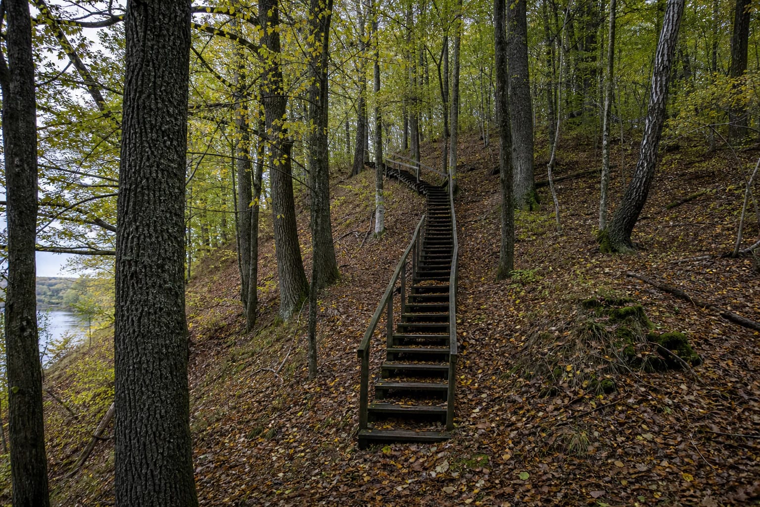
In 2003, oak steps and terraced paths, a timber footbridge over the Kirmija, signs, an information board, and a rest area were installed for visitors. Structures were laid without cutting into archaeological deposits, and the surface below raised steps was reinforced against erosion. That design is part of the conservation story, but timber, treads, and wet woodland paths age. Check the latest municipal information before travelling and never bypass a closure on site.
Official sources list no ticket office, admission charge, gate, or fixed opening hours, so this is a self-guided outdoor site. Daylight is the safest time to visit, and 1.5-2.5 hours is sensible for the loop. The steep terrain, stairs, roots, and footbridge do not form a confirmed step-free route; the climb may be unsuitable for a wheelchair, reduced mobility, or a pushchair.
A 4.7 Google score reflects a woodland walk, not a promise of dry paths or an unobstructed panorama
On 15 July 2026, the latest publicly indexed figure for the exact Google Maps place Radžiūnų I piliakalnis was 4.7 out of 5 from 80 reviews. It clears the 4.5 threshold and belongs specifically to complex 22601 at 54.374300, 24.005300. The average and review count can change over time.
The score makes most sense at the scale of this site. There is no masonry, indoor exhibition, lighting, or permanently open viewing platform. The experience is a walk through deciduous forest, the Kirmija valley, timber steps, and an earthwork read beneath trees. Dense summer leaves may hide the Nemunas, and a trail can be muddy after heavy rain even when its map reviews are excellent.
Stay on marked routes, never climb directly up an eroding slope, and do not dig or use a metal detector. In the reserve, leave rare plants, fallen timber, and wildlife undisturbed and carry out all litter. A single visit here crosses both archaeological deposits and sensitive slope habitats shaped by the Kirmija and Nemunas.