Vilnius City Municipality
Vilnius
loop route in Pavilniai Regional Park
Belmonto g. 17 ir Pūčkorių atodangos apyl., Vilnius
54.68820, 25.35920
1-3 hours, depending on the chosen loop
April-October for the trail; after rain, wear shoes with good grip
Pūčkoriai Trail
A city trail that feels like a valley hike
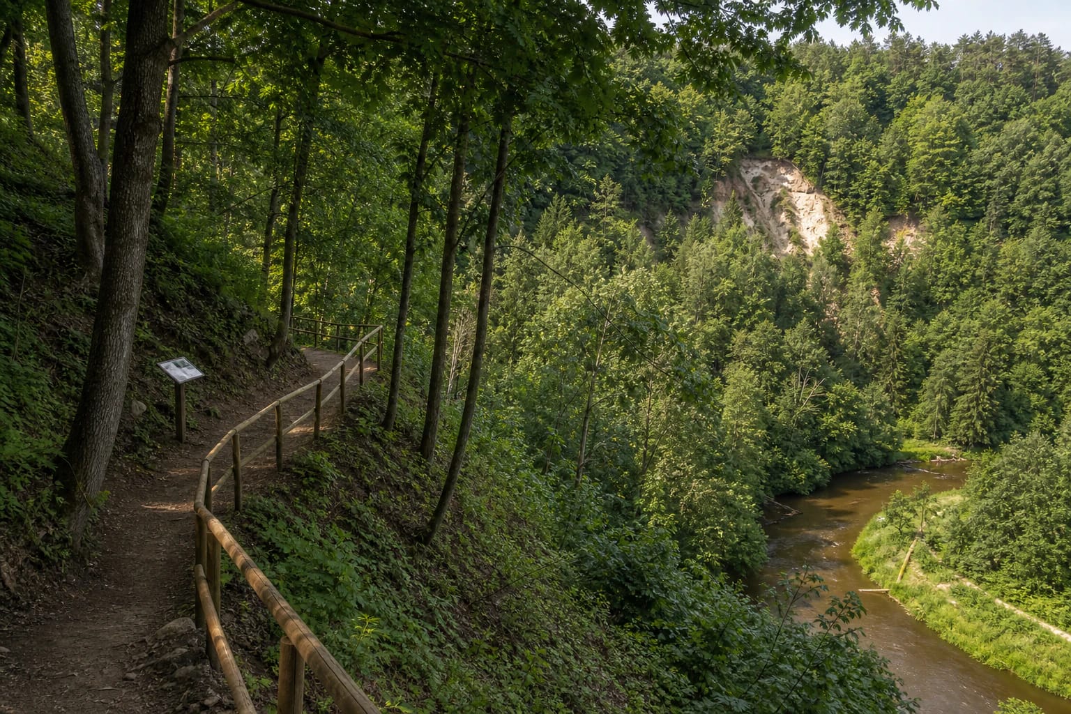
Pūčkoriai Nature Trail is one of the most convenient nature routes in Vilnius: it is within city limits, but quickly leads into the slopes, forest, outcrop, and Belmontas surroundings of the Vilnia valley.
This is not only a straight path to a viewpoint. The route offers loops of different lengths, so it suits both a short walk and a more serious several-hour outing.
Three route options
The Pavilniai and Verkiai parks directorate presents the Pūčkoriai trail with several options: 2.8 km, 3.7 km, and 5.3 km. That is practical because you can choose according to time, fitness, and weather.
The shorter loop works if your main goal is to see the outcrop and valley. The longer option gives a better sense of Pavilniai Regional Park's relief, the bends of the Vilnia, and the Belmontas-side objects.
Pūčkoriai Outcrop as the trail's axis
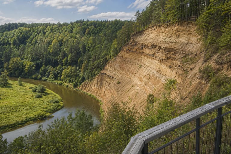
The main natural highlight is Pūčkoriai Outcrop, the largest in Lithuania. VLE gives its height as about 65 m and width as 260 m, and notes that it has been protected as a geological natural monument since 1974.
VLE records that the slope of the Vilnia erosional valley exposes deposits laid down by the Middle Pleistocene Medininkai glacier and its meltwaters: loam, boulders, gravel, sand, and varved clay. In places the layers were crumpled or overturned by the later Nemunas glaciation. The outcrop even yielded glacier-transported blocks: Jurassic grey clay with belemnite and ammonite remains, and a Cretaceous chalk block.
On the trail page, the outcrop matters not only as a record-holder but as an orientation point. From it, the depth of the Vilnia valley, the structure of the slopes, and the rugged character of Pavilniai become easier to understand. The slope is unstable and landslides are common, so approaching the edge is dangerous. The outcrop was studied in the twentieth century by B. Rydzewskis in 1925, later by V. Čepulytė and other geologists.
Belmontas, the Vilnia, and historical traces
Visitors often start either by the Belmontas mill area or from the top of Pūčkoriai Outcrop. Both starting points are convenient, but the route feels different: from Belmontas you get more of the valley first, while from the outcrop you begin with the panorama.
VLE links the name Pūčkoriai with the cannon foundry that operated on the left bank of the Vilnia in the seventeenth to nineteenth centuries; in Polish, puszkarnia means cannon foundry. Nearby contexts include Pūčkoriai Hillfort and the manor, so the route has a historical layer as well as a natural one.
Pavilniai Regional Park was established in 1992 and covers 2,176 ha. It protects the erosional hills and ravines of Vilnius and the Vilnia valley landscape. The Antakalnis bunkers contain one of the largest bat wintering sites in southeastern Lithuania, with six species including the western barbastelle, rare in Europe.
Difficulty and footwear
Although the trail is inside the city, it is not a flat park path. Slopes, steps, forest surfaces, and slippery stretches after rain can require proper footwear.
With small children, choose the shorter loop and allow more time. After heavy rain, avoid the steepest sections or walk more carefully, because Pavilniai slopes become slippery quickly.
How not to overload the route
Pūčkoriai Trail is often combined with the Belmontas cafes and recreation area, so weekends can be busier. For a quieter walk, start in the morning or avoid the main weekend rush.
Park only in permitted places, stay on marked trails, and do not climb onto the unstable outcrop slopes. That is safer and also essential for protecting the geological object.