- Place
- Kretinga District Municipality
- Region
- Samogitia
- Type
- 22-metre-high and 44-metre-long Minija valley outcrop with a viewpoint and 1.8-kilometre Šilpelkė nature trail
- Address
- Šilpelkė Forest, Dauginčiai, Kartena eldership, Kretinga district
- Coordinates
- 55.95171, 21.55063
Lietuvos Šveicarija, Dauginčiai Cliff, Dauginčių atodanga, Šilpelkė Forest outcrop
Navigate to the trailhead, not the cliff coordinates
The Google Maps pin and viewpoint for Dauginčiai Outcrop sit at 55.9517075, 21.5506292, but visitors should not try to drive to the cliff. The official 1.8-kilometre loop begins at 55.95160, 21.53935, at the rest and parking area beside the old Dauginčiai cemetery. Almost one kilometre of woodland path separates the two points.
Leave the A11 Šiauliai-Palanga highway near Dauginčiai and follow local gravel roads towards the Minija for several kilometres. At the final junction, use signs for Dauginčiai Outcrop and the Šilpelkė trail rather than trying to shorten the approach on forest tracks. The gravel can be potholed after rain, so adjust speed to conditions.
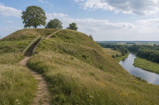
From the cemetery, follow the on-site arrows. The route passes Dauginčiai Hillfort, climbs timber stairs to the top of the outcrop, descends through hornbeam woodland, and follows the Minija back to the start. The current directorate page measures the loop at 1.8 kilometres; the 1.5-kilometre figure still found in 2014 sources reflects an earlier calculation.
A 22-metre cliff is a living river section, not a static rock wall
Dauginčiai Outcrop rises to 22 metres and extends for about 44 metres. It formed where the Minija erodes the outside of a bend and continuously exposes sediment in the valley slope. Falling sand and clay, uncovered roots, and toppled trees belong to that natural process rather than indicating neglected maintenance.
Descriptions call the outcrop a record of the two latest glaciations. Its section includes glacial deposits associated with the Žeimena and Upper Nemunas stages, interleaved with sand, silt, and clay. These are relatively young Quaternary sediments rather than solid ancient bedrock, which makes climbing at the edge or below the face dangerous.
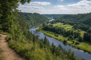
Two viewpoints are needed to understand its scale. The safe platform above shows the Minija bend, the opposite valley slope, and the direction of Prystovai; the eroded face is clearer from the river on a lawful canoe route. Walkers do not need to descend to the unstable foot of the cliff for a photograph.
Why local people call the area Lithuanian Switzerland
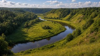
Lithuanian Switzerland is a local nickname, not an official geographical name or a claim to Alpine elevation. It describes the entire strongly undulating Minija valley landscape: steep forested slopes, deep ravines, river loops, and terraces at several heights, not merely the 22-metre cliff.
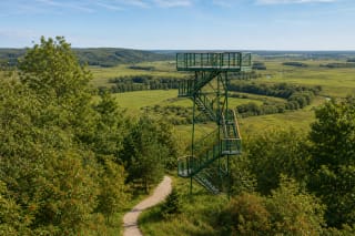
The river turning below is the viewpoint's principal subject rather than a distant skyline. Before leaf-out in spring, the shape of the bend and the opposite slope are easiest to read. Mature summer foliage hides parts of the river and cliff but creates shade and a strong woodland-water contrast, while deciduous trees colour the valley in autumn.
The platform stands above an active natural slope, so its rail is a safety boundary rather than an invitation to seek a better angle beyond it. River erosion can undercut apparently dry ground. Do not cross barriers, sit on the cliff lip, or allow children and dogs near an unprotected edge.
The Šilpelkė loop joins Natura 2000 woodland, a hillfort, and an old cemetery
Šilpelkė, also called Dauginčiai Forest, is a naturally established Minija valley woodland within the Natura 2000 habitat-protection area around Dyburiai. The loop was created not only for convenience but to channel visitors away from sensitive slopes, ravines, and habitats that informal paths would damage.
A park-like hornbeam stand is one of the route's defining habitats and among the more northerly concentrations of hornbeam in Lithuania. Forested ravines and steep slopes maintain a cooler, moister microclimate, while dead wood supports insects, fungi, and woodland birds. Fallen branches away from the maintained line are habitat, not rubbish to drag aside.
Kingfishers may nest by digging burrows into steep sandy banks exposed by erosion. The brilliant blue bird is never guaranteed, although a quiet morning walk improves the chance of seeing one flash over the water. Stay away from burrows, avoid shouting from the cliff, and do not lure birds with recordings.
Moon Hill and the cemetery preserve a longer human memory
Opposite the old cemetery at the start of the trail stands Dauginčiai Hillfort, known as Pilalė or Moon Hill. A crescent-shaped mound explains one name, but ideas about ancient ritual use remain hypotheses. A second Dauginčiai hillfort called Pilis occupies the promontory at the confluence of the Minija and Slinkupis; the two should not be merged into one site.
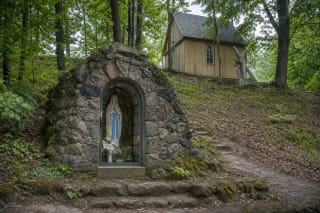
The old Dauginčiai burial ground is also called the Plague Cemetery or Senkapiai. The protected-areas service records burials during epidemics and notes that after parish cemeteries became standard in the late eighteenth century, the old ground remained in use into the mid-twentieth century for people excluded from conventional consecrated burial. Crosses and wayside shrines maintained its sacred character.
The tradition of May devotions at the cemetery survives, so the trailhead is not simply a picnic area. Keep access clear, stay off burial mounds, do not handle crosses, and choose a place away from the memorial ground for any noisy rest, even when no service is taking place.
Surface, stairs, hours, and a 4.8 rating
Most of the Šilpelkė route follows natural forest ground, with timber stairs, footbridges, and rails on steep sections. Boards, roots, and clay become slippery after rain, and low areas may hold water. Wear shoes with grip; the complete loop is unsuitable for a wheelchair or pushchair because of steps, gradients, and uneven surfaces.
This is officially a walking trail, so bicycles are best left at the vehicle. Carry a small child only in a properly secured carrier on the stairs. Official pages list no permanent toilet, drinking-water point, cafe, or staffed office at the trailhead. Carry waste out and obey temporary closures after storms or tree falls.
In July 2026, Google Maps marked the outcrop as a free outdoor site open 24 hours and rated it 4.8 out of 5 from 326 reviews. That is not advice to walk after dark: the path is unlit, the cliff is steep, and signs are easier to follow by day. Ratings change, while current on-site signs and the Žemaitija Protected Areas Directorate remain the essential sources for immediate conditions.