Klaipėda District Municipality
Klaipėda District
erosional Minija River valley landscape
55.77600, 21.44200
1-3 hours for a chosen valley section; longer with Minija riverside routes
spring and autumn for the valley relief; summer for a slow river and riverside route
Minija Ancient Valley Landscape Reserve
Minija Ancient Valley: more than a riverbank
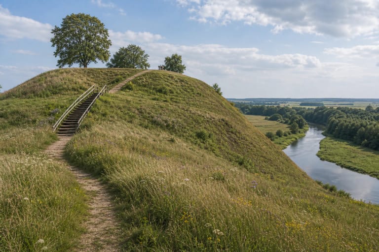
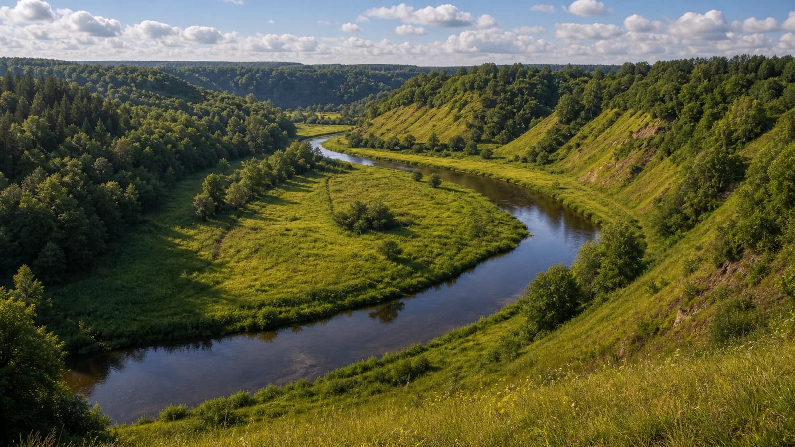
The Minija Ancient Valley is a place where the key feature is not only the ribbon of water, but the whole valley relief. Saugoma.lt says the Minija Ancient Valley Landscape Reserve was established to preserve the expressive erosional landscape of the Minija River's ancient valley: not a single object, but an entire river-carved valley with slopes, ravines, and old terraces.
It is best visited as a geographical landscape. From higher slopes or riverbanks, it becomes clear how the Minija gradually cut the valley and how its bends relate to meadows, woods, and homesteads. This is one of the most expressive examples of a river ancient valley in western Lithuania.
The scale of the Minija and the depth of the valley
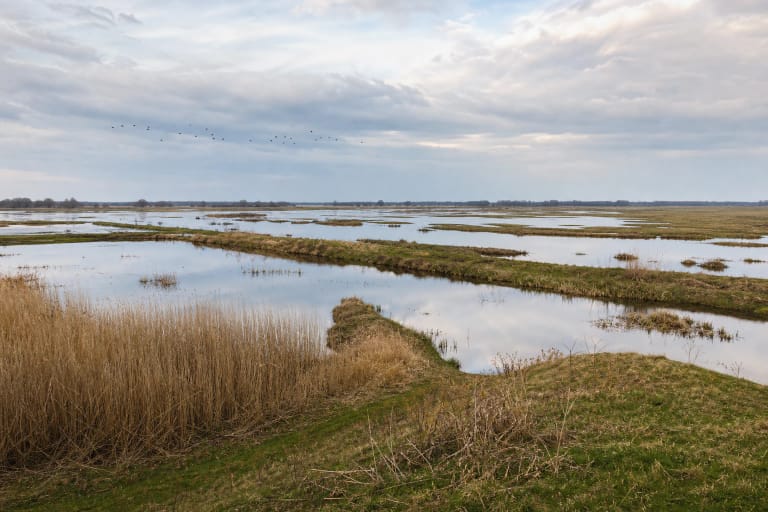
VLE states that the Minija is a 202 km river rising from Lake Didovas, 3 km east of Žarėnai; its basin covers 2942 km². In its upper reaches, descending the western slope of the Samogitian Upland, the river has a steep gradient. After entering the Coastal Lowland and receiving the Salantas, it turns south and winds through the ancient valley past Kartena, Gargždai, and Priekulė. Finally the Minija flows into the Atmata, a branch of the Nemunas Delta, 3 km from its mouth.
In the ancient-valley section, the important thing is not the width of the river but the height of the slopes and the scale of the valley. VLE notes that the valley is 400-600 m wide in the Samogitian Upland, about 1 km wide in the Coastal Lowland, and its slopes are 15-40 m high. At exposures the banks rise to 10-15 m, creating a deep, impressive space best experienced on foot or by slowly moving between selected points.
Erosional slopes, exposures, and sensitive banks
The erosional landscape is beautiful because it is active and sensitive. VLE mentions that the Minija channel, especially between Stalgėnai and Nausodis and near Dyburiai, has many stony rapids and large boulders, while exposures open in the valley slopes. Steep slopes, landslide areas, and ravines should not be treated as open off-trail routes: unofficial paths across slopes increase erosion.
In protected areas, stay on existing roads, paths, and viewpoints. This is especially important in the Minija Ancient Valley: the value of the landscape lies in the landforms and exposures themselves, so preserving them is part of visiting. Some slopes and banks may be private or dangerously steep, so choose stops and descents responsibly.
One part of the long Minija system
The Minija Ancient Valley is only one protected section in a large river system. VLE notes that the Minija flows through two regional parks (Salantai and Nemunas Delta), two landscape reserves (Minija and Minija Ancient Valley), and past the Minija Ichthyological Reserve. Paplienija, Stalgėnai, Lekemė, Kartena, Antakalnis, Gerduvėnai, and Dovilai hillforts stand by the river.
This context helps show that the ancient valley is not a random scenic place, but a key relief stage between the Samogitian Upland and the Coastal Lowland. In the Nemunas Delta plain the valley becomes very shallow and below Priekulė disappears altogether, so the ancient-valley section best shows the river's erosional power.
What to do in the Minija Ancient Valley
The Minija Ancient Valley suits a slow journey: stop at a river bend, climb to a safe viewpoint, compare slope heights, and see how the river separates different landscape levels. In spring and autumn, when foliage is thinner, the relief and exposures are easiest to read.
If you plan to paddle or travel along the bank, check local conditions, access points, and protected-area boundaries. Not every beautiful slope is suitable for landing or parking. The valley pairs well with Kartena Hillfort, Salantai Regional Park sites, and Pamarys routes, so the river can be understood as a long system from the Samogitian uplands to its lower reaches.