- Place
- Kretinga District Municipality
- Region
- Samogitia
- Type
- 15-metre steel observation tower and the start of the 2.3-kilometre Salantas Lower Valley nature trail
- Address
- 10 M. Valančiaus St, Kalnalis, Kretinga district
- Coordinates
- 56.01725, 21.54139
Kalnalis Watchtower, Kalnalis Tower, Salantai Observation Tower
Drive to the church, not all the way to the tower
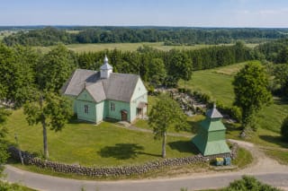
Kalnalis Observation Tower stands in Kalnalis village near regional road 226 between Salantai and Kartena, at 56.0172547, 21.5413865. Select the tower pin in navigation, but drive only as far as the parking area beside Kalnalis Church of St Lawrence. Continue behind the rectory on a short footpath marked by wooden arrows.
The low three-tier timber bell tower beside the church is not the observation tower. The public lookout stands slightly higher among trees and is an open green steel structure with switchback flights of stairs. The distinction matters because the churchyard, cemetery, and parish grounds lie between the two, and their gates must not be blocked.
There is no ticket office or staff at the lookout, and the final approach is not intended for visitor cars. Light footwear is sufficient for a dry tower-only stop, but the valley walk calls for sturdier shoes and water because the trail itself has no services.
Why fifteen metres are enough here, and what the 2022 repair changed
The tower was built in 2006. Several straight flights of metal stairs switch back to a polygonal open platform enclosed by mesh railings. The deck is fifteen metres high, but the structure begins on Kalnalis's natural upland, so the sightline clears the trees and reaches much farther across the valley than the number alone suggests.
After years of use, the tower required a capital repair rather than a cosmetic repaint. The regional-park authority announced in 2022 that the work was complete and the site had reopened for visitors. Old web reports of broken barriers or an untrustworthy structure describe the period before that intervention, not its current official status. Always obey any temporary closure and warning posted on site.
This is not an obscure roadside structure. The Žemaitija Protected Areas Directorate counted 10,995 visitors here in 2025, the second-highest figure among all sites it administers. The small platform can therefore feel busy on weekends or feast days, and a weekday morning offers a calmer experience.
Finding Imbarė, Gaidžio Chapel, and Salantai in the panorama
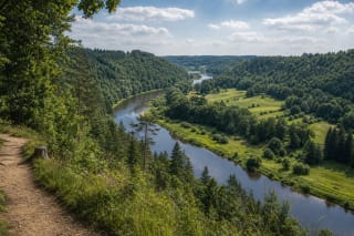
The defining view opens across the broad Salantas ancient valley rather than equally through a perfect 360 degrees. Mature trees block part of the southern outlook, so the strongest panorama follows the valley towards Imbarė and Salantai. Landforms are easiest to read in spring before full leaf and again in late autumn.
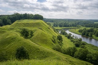
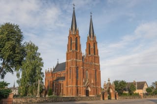
The nearest major historical landmark is Imbarė Hillfort, the green upland above the Salantas where a Curonian stronghold once stood. Farther away, look for the small Neo-Gothic Gaidžio Chapel on its own hill and the twin red towers of Salantai Church of the Assumption. Alka Hill is another feature in the wider Salantai relief, but without a map or binoculars it can blend into neighbouring moraine hills.
A map on a phone helps with orientation, but compact binoculars are better for the distant structures. The landmarks lie kilometres away and can disappear behind summer foliage or atmospheric haze. Even in cloud the scale of the ancient valley rewards the climb, but do not treat the church towers or chapel as guaranteed in every weather condition.
What the Lower Salantas Hydrographic Reserve protects
The tower overlooks the 1,119-hectare Lower Salantas Hydrographic Reserve, established in 1995. It protects a natural section of the river's ancient valley and channel, the confluence of the Salantas and Blendžiava, natural floodplain meadows, and their habitats. The greenery below is therefore not just a scenic backdrop but a protected river, landform, and ecological system.
The broad, flat-bottomed valley belongs to a landscape shaped by glacial meltwater and later river flow. From above, visitors can compare the high Kalnalis slope, low meadow floor, winding belts of riverside vegetation, and uplands rising on the opposite side. These existing differences in elevation make a fifteen-metre tower more effective than a much taller lookout on flat ground.
Protected habitats include lowland hay meadows and species-rich grasslands, with populations of corncrake, kingfisher, and European brook lamprey. A summer evening walk may reveal the hidden corncrake by its voice, but no bird sighting is guaranteed. Stay on the trail, prevent dogs from chasing meadow birds, and leave flowering plants where they grow.
2.3 kilometres to Imbarė means 4.6 kilometres out and back
The Salantas Lower Valley nature trail from the tower to Imbarė Hillfort is 2.3 kilometres in one direction. If your car remains at Kalnalis, the same return adds another 2.3 kilometres, producing at least 4.6 kilometres before time spent climbing and exploring the hillfort itself.
The official route is intended for walkers and cyclists and crosses the Salantas valley, natural meadows, and the riverside. It is not a short urban park path with a continuous hard surface. Low sections may be wet after rain, grass can grow high, and waterproof footwear helps in spring and autumn. Leave a bicycle below the tower stairs and yield to walkers on narrow sections.
The route works best as a sequence of landscape and history: Kalnalis church recalls the baptism of Motiejus Valančius, the tower explains the scale of the ancient valley, and Imbarė reveals an early medieval Curonian centre. If you lack time for the return walk, visit the tower and hillfort separately by car rather than starting without accounting for the full distance.
Hours, stairs, weather, and a 4.6 rating
In July 2026, Google Maps listed the tower as open 24 hours, while the official protected-areas page published neither separate hours nor a ticket. That describes a freely accessible outdoor site, not an illuminated and supervised night attraction. Climb in daylight when steps, trail signs, and weather are visible; stay off during thunderstorms, high winds, ice, or any posted closure.
Only metal stairs reach the platform. There is no lift, ramp, or alternative step-free upper viewpoint, so the top is inaccessible to a wheelchair and a pushchair must remain below. The steps and decks are open-grid metal: keep young children beside you, do not let them climb alone, and do not carry them unsecured on your shoulders.
Admission is free, but there is no cafe, toilet, or attendant at the tower, so prepare before leaving the church parking area. In July 2026, its Google Maps listing was rated 4.6 out of 5 from 356 reviews. Ratings change, and immediate safety always depends on signs posted on site and the day's conditions.