- Place
- Arminai I, Alytus eldership, Alytus District Municipality
- Region
- Dzūkija
- Type
- the severely eroded hillfort component of a nationally significant archaeological complex with a settlement at its foot
- Address
- Arminai I village, Alytus eldership, Alytus District Municipality; shown as Aniškis on Google Maps
- Coordinates
- 54.40534, 23.88323
- Visit duration
- 30-45 minutes to examine the legally accessible banks and ditch, excluding the unverified approach
- Best time
- a dry, leafless day in early spring or late autumn, when the banks are visible and neither the steep slopes nor the leaf litter is wet
Aniškio piliakalnis, Arminų piliakalnis, Arminų, Aniškio piliakalnis su gyvenviete, Arminai (Aniškis) Hillfort
One exact place carries the names Aniškis and Arminai and two eldership labels
The exact Google Maps place is in Aniškis Forest at 54.4053351, 23.8832252. It is a site point on the archaeological monument, not a car park, gate, or verified trailhead. Google calls the place Aniškis, while the official complex name is Arminai and Aniškis Hillfort with Settlement. Aniškis and Arminai therefore do not identify two different hillforts.
The official address fields conflict. The header of the current complex record assigns Arminai I village to Krokialaukis eldership, while the records for both components and Alytus District Municipality's visitor-site list place the same monument in Arminai I, Alytus eldership. This page follows the more specific component records and the municipal list, while using the exact point for navigation.
On 15 July 2026, the Google Maps listing was named Aniškio piliakalnis, carried place ID ChIJHQSrdAC34EYRrf55KZuJNbg and CID 13273666776253202093. It averaged 5.0 out of 5 from one review. That score formally clears the 4.5 threshold but is not a stable measure of quality or access and could change sharply after one new rating.
The stream left an enclosure remnant only 13 by 3 metres
The hillfort occupies the edge of high ground near the southeastern shore of Lake Gudeliai, on the left bank of an unnamed stream. The stream encloses the hill from the north and northeast, while gullies descend into its valley from the east. Natural relief and human-made defences now overlap on this wooded spur.
The current register description records an east-west enclosure remnant about 13 metres long and no more than 3 metres wide beside the bank. The stream washed away most of the earlier enclosure, and the register's overview says that the loss had already occurred before the twentieth century. The surviving ground therefore cannot be used to imagine a complete hillfort plan.
The register describes the hillfort's own cultural deposit as unexcavated and washed into the stream. Pottery and charcoal had reportedly appeared on the eroded slope, and a quern was found near the stream at the foot, but these isolated observations cannot reconstruct buildings or events on the lost summit. Finds from the separately registered settlement must not be transferred automatically to the former enclosure.
The massive first bank overshadows what remains of the enclosure
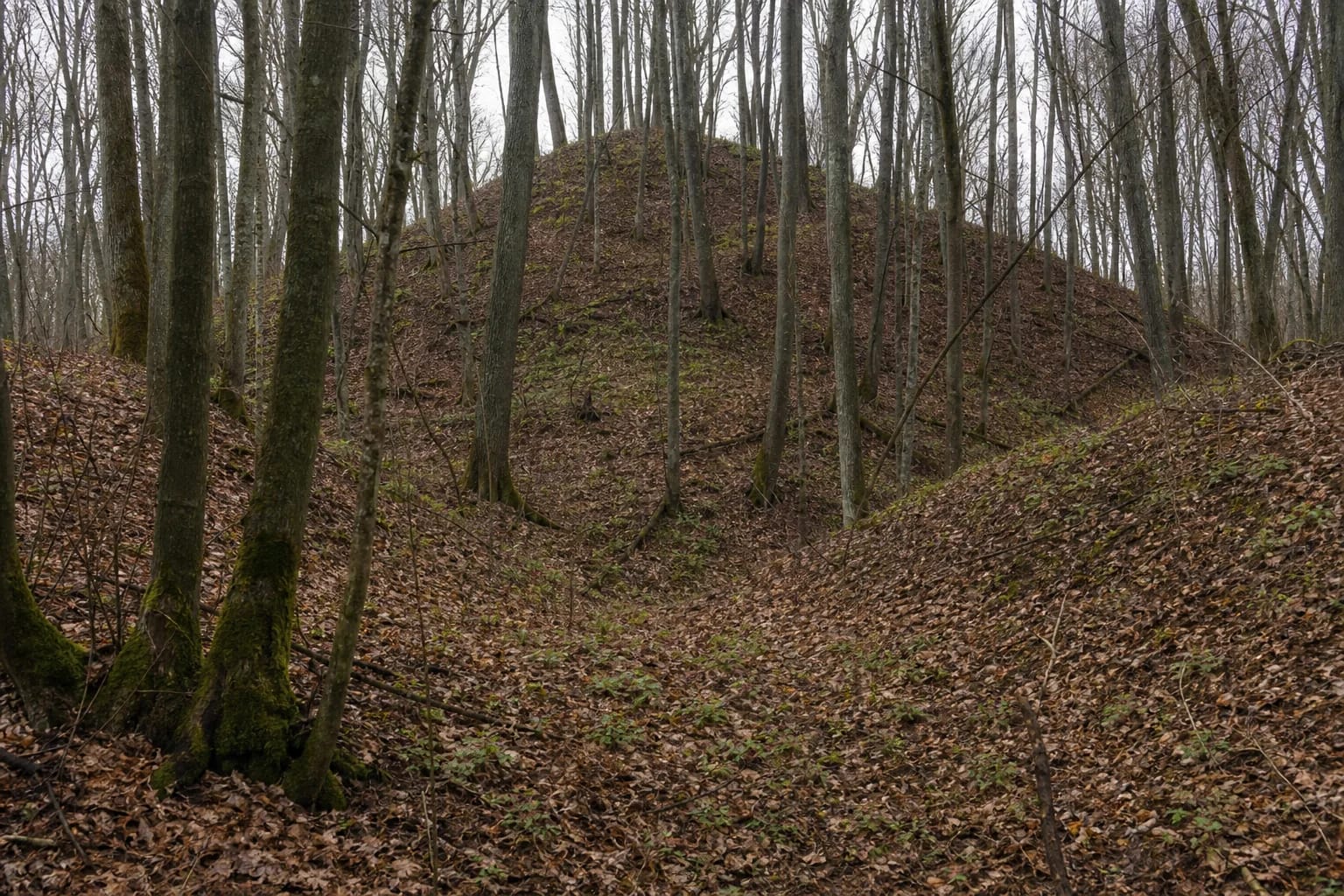
The first bank crosses the southern edge of the enclosure and measures roughly 20 metres long, 20 metres wide, and 6 metres high above the surviving interior. Its outer slope is about 8 metres high. Probing in 1954 established that it was built from clay-rich earth. A later pit cuts its crest, and deciduous trunks and roots now cover the entire mass.
Beyond the first bank is a ditch about 7 metres wide at the top, 2 metres wide at the bottom, and up to 1.5 metres deep. On its far side survives a second bank roughly 4 metres wide and only 0.4 metres high. It has been levelled and reads in the leaf litter as a low rise rather than a separate wall. The three features are easiest to distinguish in the leafless season by looking across their alignment.
The slopes towards the stream are steep, actively eroded, and about 15 metres high. Register photographs are dominated by the high rounded body of the first bank among dense grey deciduous trunks and by a ditch floor buried under leaves. They show neither castle ruins nor a reconstruction. The visible monument is an earthwork whose present profile reflects both its bank and long-term erosion.
The settlement deposit and finds from different surveys must remain distinct
Hillfort 1849 and settlement 22604 form complex 22603. All three records carry legal monument status and a national level of significance, and the register dates them from the first millennium CE to the beginning of the second millennium. The current registered territory of the whole complex covers 47,556 square metres, or about 4.76 hectares, with a 154,711-square-metre visual protection subzone. These are not the area figures of the settlement alone.
The settlement extends across rolling high ground west and southwest of the hillfort and over flatter land at the northern foot on the opposite side of the stream. The register records a dark cultural deposit 40-50 centimetres deep with archaeological finds. Most of the territory is wooded, its southwestern part lies fallow, and earlier ploughing damaged the deposit in places.
The finds come from different surveys, not one extensive excavation. Rough-surfaced and wheel-thrown pottery and iron slag were found on the surface in 1954, followed by a spindle whorl in 1989. In 2000, Eugenijus Svetikas surveyed rather than excavated the site with a metal detector. The primary publication notes several first-millennium pottery fragments and assorted metal fragments, while the register identifies striated, burnished, and rough-surfaced pottery from that campaign. More rough-surfaced sherds were found at the northern foot across the stream in 2020.
The sunken church and bells beneath the lakes belong to legend
The hillfort component entered the register in 1992 and the complete complex in 1996. The official cultural-monuments list preserves the earlier codes A68KP and AR58. A 2004 amendment added the place names Arminai and Aniškis to what had been a generic register title. These documents explain the modern naming history, not what the hillfort was called while it was occupied.
The register records folklore about a church said to have stood on the hillfort and later sunk into the ground. The story continues that its bells can still be heard in the surrounding lakes. This is a meaningful expression of local memory, particularly beside nearby Lake Gudeliai, but the wording said to have is essential.
Neither the register's description of significant features nor the 2000 survey summary reports church foundations, bells, masonry, or a documented date when a church sank. The tale must therefore not be presented as the history of a known church. Current photographs show deciduous forest, earthen banks, and erosion-altered relief, not ruins of a place of worship.
The map pin is neither a trailhead nor a car park
The official sources checked publish no current marked final route, dedicated car park, steps, handrails, information panel, benches, or toilet. The Alytus District list confirms that this is a visitor site but gives no approach instructions. A round-the-clock schedule displayed on Google Maps is not an official opening time, and the sources likewise confirm neither an admission charge nor a policy of free access.
Use navigation only to locate the area, not to drive directly to the coordinates. Leave a vehicle solely where parking is lawful and where it will not block forestry, farm, or residential access. Do not drive onto an unsigned forest track or cross private land simply because a pin appears on the map. If no clearly permitted approach is present or signs restrict access, postpone the visit.
If a lawful route is marked on the day, choose dry weather and daylight. Wet leaves hide the edges of the ditch, the 15-metre slopes are steep, and the stream-cut edge may be unstable. Stay back from the erosion scarp, keep children from running down the banks, do not climb directly across the earthworks, and never disturb soil or collect finds noticed on the surface.