- Category
- Lost settlement histories
- Reading time
- 3 min.
- Sources
- Local history interpreted from cited sources
1509: a written mention, not a birthday
The Curonian Spit National Park account identifies Karvaičiai in the 1509 Kuncai account book. This is a dated written trace. The village may have existed earlier, so its first known mention should not be presented as its foundation.
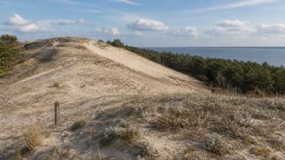
The historical locality is associated with Karvaičiai Bay, north of Ožkų Ragas, between present-day Preila and Pervalka. These landmarks describe an area rather than the position of every former home.
Around 1600: a long process begins
The park's dune account associates thinning woodland around 1600 with increasing sand movement. This is an approximate period in a process, not the date of a single storm. The disappearance of the village cannot be compressed into one dramatic night.
Distinguish environmental change, residents' attempts to remain and their final departure. All may be described as sand engulfment, but they belong to different timescales.
1776 and 1797: a living village and its final departure
Liudvikas Rėza was born in Karvaičiai in 1776. The biographical date reminds us that the threatened settlement was still people's home. The park source dates the departure of its last inhabitants to 1797.
That year marks a break in the settlement's history, not an end to its inhabitants' lives or memories. Family research must follow those who moved elsewhere, rather than treating them as lost with the village site.
1995 and the landscape today
Karvaičiai Dune received natural-heritage protection on 18 December 1995. This dates a conservation decision, not the village's existence.
The dune, former settlement and memorial are not interchangeable map points. For a visit, use the separate Karvaičiai site guide and current park information. A historical description does not establish access across protected dunes.
Keeping a useful place record
Label each date by what it records: a written mention, a birth, a departure or a protection decision. Label each location as an approximate village area, a visible landform or an accessible memorial. A single pin should not silently stand for an entire vanished settlement.