- Place
- Kazlų Rūda Municipality
- Region
- Suvalkija
- Type
- captured low-flow spring with two chapels
- Address
- Šaltinėlio Street, Višakio Rūda village, Kazlų Rūda Municipality
- Coordinates
- 54.82558, 23.44211
- Visit duration
- 30-60 minutes; up to 1.5 hours to see both chapels and the forest setting slowly
- Best time
- daylight from spring to autumn; check access after heavy rain and never treat an old water analysis as proof of present safety
Višakis Spring, Višakio Rūda Holy Spring, Višakio Rūda Spring and Chapel
Google and municipal pins agree, while the final approach leaves the village for a wooded slope
The exact Google Maps card Višakio Rūda Sacred Spring marks 54.8255783, 23.442111, place ID ChIJ_ynbn23a5kYRDC3xnAATg6A. Kazlų Rūda Municipality's map pin, 54.8256766, 23.4421255, lies about 11 metres away, so both identify the same site. On 15 July 2026, Google showed an average rating of 4.6 out of 5 from 23 reviews and categorised it as a spring. That changing visitor score is not a certificate of water quality or healing power.
The Lithuanian Geological Survey places the spring on the northern edge of Višakio Rūda, about 1.5 km north-east of the twin-towered church and roughly 0.3 km from the former forestry landmark. It lies at the southern edge of Lekėčiai Forest on the right side of the River Višakis valley. From the upper rest area, a broad path descends several dozen metres along a gentle slope to the spring.
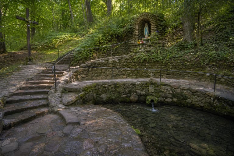
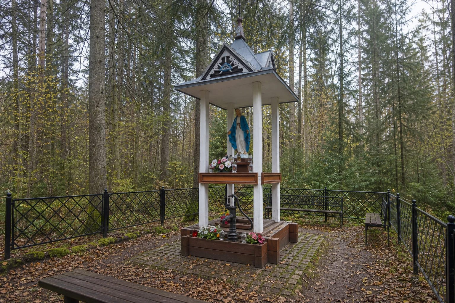
At the bottom, visitors find a maintained devotional complex rather than an open pool bubbling from the ground. Official photographs show a black openwork metal fence, a stone-paved clearing, benches, a hand pump, and an open chapel carried by four white posts. Beneath its roof stands a statue of the Virgin Mary in blue and white, while flowers and candles show that this remains an active place of prayer.
Beneath the chapel is a very small groundwater outlet, not a powerful fountain
The Geological Survey classifies the feature as a falling, or erosional, spring at the foot of a damp slope. It is permanent but prone to silting, has only a faint drainage channel, and can freeze in a colder winter. Its discharge falls in the low, indeed lowest, category, so a slow flow or the need to work the pump is not in itself evidence that the spring has failed.
The spring emerges at about 56 m above sea level on the right bank of the 44.5 km River Višakis. Wind-blown sand, sediments laid down in a glacial lake, and alluvium deposited by the river meet here. Sand readily absorbs rainfall, while deeper moraine clay impedes the rise of pressurised groundwater, leaving only a modest unconfined groundwater outlet at the surface.
People captured, or capped, the spring in a square concrete wellhead fitted with a mechanical hand pump. Overflow is led west through a small channel into wet ground draining towards the Višakis. This structure makes water easier to collect and protects the opening, but it does not turn the spring into a monitored public water supply.
The 2014 water figures are a useful geological snapshot, not a present-day licence to drink
On 5 June 2014, field measurements found clear, odourless water at 9.9 degrees Celsius and a neutral pH of about 7.0. The laboratory table recorded total mineralisation of 198 mg/l and total hardness of 2.34 milliequivalents per litre. The dominant ions made it a weakly mineralised, soft calcium-magnesium bicarbonate-sulphate water.
No nitrite was detected in that sample, and the nitrate concentration of 0.52 mg/l was close to background. The same analysis recorded total iron of 0.68 mg/l and a permanganate index of 7.2 mg O/l, indicating a higher amount of organic matter. Every figure belongs to one 2014 sample and says nothing about contamination that may have arrived eleven or twelve years later, particularly after downpours, snowmelt, or damage to the capture.
Lithuania's National Public Health Centre warns that the appearance, smell, and taste of spring water do not reveal microbial or chemical contamination and that public spring captures require regular testing. No newer public microbiological and chemical result for this exact spring was found while preparing this guide. The water is therefore not described here as safe to drink: only a current official laboratory result displayed on site or by the responsible authority can support that decision.
The forester's wounds, the blind soldier, and the apparition of Mary belong to legend, not medical history
Kazlų Rūda Municipality and the Geological Survey record two principal local traditions. One says that around 1700 a forester became lost in the woods and waded through a mire, then noticed that chronic wounds on his legs were healing and returned to look for the tiny spring. In the other, a blind soldier returning from war is said to have drunk and washed here, regained his sight, and seen the Virgin Mary.
These stories explain why people collect the water, wash with it, and leave candles and flowers around the wellhead. They are an important part of local religious memory, but neither the forester's cure nor the soldier's restored sight is a documented clinical case. Spring water cannot replace a medical diagnosis, prescribed medicine, or treatment.
The small tower above the well holds a statue of Mary, while the Lithuanian prayer words meaning We seek your protection are written on the concrete surround. Treat the clearing as a living sacred place: keep voices low, do not disturb votive offerings, never place candles in forest litter, and respect other visitors' beliefs. Distinguishing evidence from legend allows both science and tradition to be taken seriously.
The spring chapel is tied to a nineteenth-century church project, but the age of today's boards is unknown
An archival statement in Lithuania's Register of Cultural Property records that Višakio Rūda's first church, or chapel, was built with parish donations in 1817. When the present large wooden church rose around it over four years in the later nineteenth century, the older chapel was dismantled. Its better wall timbers were reused between windows, and the remaining material was taken to the spring to build a chapel.
This record confirms a historic bond between church and spring, but it does not date every piece of the structure visible today. In 2014, the Geological Survey described two chapels in the complex: one on the hill and another below over the well itself. Wooden parts may have been repaired or replaced during generations of use, so the accurate claim is continuity of place rather than an unchanged nineteenth-century building.
The name Višakio Rūda preserves another documented layer of the landscape. The settlement was named for the River Višakis and bog iron ore, which was smelted here with water power. The Geological Survey mentions two smelters operating until the mid-nineteenth century and an industry lasting into the early twentieth century. Water in this landscape therefore supported both sacred meaning and economic history.
At the reserve edge, the wet Višakis Valley vegetation deserves as much care as the shrine
The Geological Survey places the spring at the western edge of Višakis Valley Botanical Reserve. Saugoma.lt says the 104 ha reserve was established in 1996 to protect characteristic aquatic, mire, meadow, and wet-forest vegetation, including sites of Baltic marsh orchid, heath spotted orchid, and one-leaved bog orchid. Do not trample wet ground in search of rare plants; observe from the existing path.
The official sources checked publish no separate admission charge, ticket office, or fixed opening hours for the spring, and the exact Google listing showed no timetable on the verification date. That does not guarantee lighting, supervision, or safe access at every hour. Visit in daylight, wear footwear suited to a damp slope after rain, and follow any parish notices during services or larger gatherings.
Allow 30-60 minutes for the spring. A broader route can add Višakio Rūda's timber church, Kazlų Rūda Forest Nature Trail, and Liepa Motinėlė at Braziūkai. Together they show how Suvalkija's forests hold geology, bog-iron history, protected habitats, and sacred local memory within the same landscape.