- Place
- Smalininkai eldership, Jurbarkas District Municipality
- Region
- Lithuania Minor
- Type
- a state-protected botanical natural-heritage group of oak trees forming an avenue
- Address
- Smalininkai-Vidkiemis landscape, Smalininkai eldership, Jurbarkas District
- Coordinates
- 55.07159, 22.56027
- Visit duration
- 30-60 minutes for a representative section; longer when walking a larger part of the linear site
- Best time
- in daylight from late spring through autumn on a dry day; do not walk the road verge in darkness or poor visibility
Smalininkai Oak Alley, Smalininkai-Vidkiemis Oak Alley
The official name is Vidkiemis, while the local shorthand is Smalininkai Oak Alley
The State Protected Areas Service uses Vidkiemis Oak Alley in its current list of botanical natural-heritage objects in Jurbarkas District. Public maps, local accounts, and travel descriptions often use the synonym Smalininkai Oak Alley, so search for both names. They refer to the same linear site, not two different oak groves.
The Environment Ministry-commissioned 2022 report by the Vytautas Magnus University Agriculture Academy records the object as "Vidkiemio (Smalininku) ąžuolų alėja" and supplies the point 55.071590, 22.560270. We mark it as representative: it helps start the search but does not pretend to identify the avenue's gate, car park, or one official visitor entrance.
This is a roadside landscape between Smalininkai and Vidkiemis, not an enclosed park
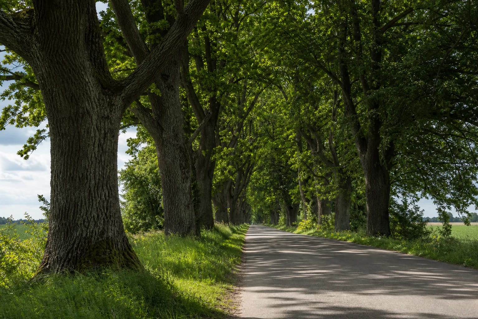
The avenue is best understood as a public-road landscape accompanied by rows of trees. VLE mentions it as a natural monument near Smalininkai, while a Jurbarkas planning document describes the old Smalininkai-Vidkiemis oak avenue. A single map pin cannot replace that landscape context: the site extends through the countryside.
Look for more than one notable trunk. The repeating rhythm of veteran oaks, grassy verges, touching crowns, and open gaps reveals the character of Lithuania Minor's lowland landscape. Depending on the section, the view may include road surface, settlement edges, or open fields.
The state sources checked do not provide one current visitor route with continuous surfacing, distance markers, benches, or information boards. This is a practical distinction: you are visiting a protected landscape object, not an equipped nature trail with guaranteed infrastructure.
A protected botanical object requires respect for the whole avenue
The VSTT list classifies the avenue among botanical natural-heritage objects. Its value lies not only in individual trees but also in their alignment, continuity, and historic roadside setting. The list's update date is 2 December 2025, and the avenue remains included under this name.
The Environment Ministry and VDU report includes this site in research on veteran pedunculate oaks and gives its location. That is a scientific inventory record, not a promise that every tree in the avenue was measured separately or that a current public condition survey for the entire group is available.
Do not climb trees, drive onto verges or root zones, hang hammocks, scrape bark, or break twigs. Photograph only from a safe place, do not create new pull-offs, and take rubbish with you. A protected avenue is a living corridor, not a backdrop for a quick stop at any cost.
The historic story matters, but there is no confirmed single planting scenario
A Jurbarkas planning document describes the oak avenue as centuries old and refers to an eighteenth-century planting period. That is a useful historical layer in an official planning document, but it is not dendrochronological dating of each surviving tree and does not prove one specific planting ceremony.
Public local descriptions repeat exact lengths, tree counts, and claims that the avenue is Europe's oldest or longest oak alley. The current VSTT page does not publish those measurements. To prevent different surveys and administrative limits from being confused, this guide does not turn one unverified figure into an official fact.
The most reliable part of the historical landscape is the avenue's continuing form and its relationship with Smalininkai. Notice how the rows frame the road, but do not infer the age or uniform condition of every tree from one impressive trunk.
Visiting means daylight, roadside safety, and treating the point as representative
Allow 30-60 minutes for one comfortable section and more time for a longer walk. Because the official point is representative, check your chosen approach before setting out and do not expect the coordinate to lead automatically to a parking place. The state sources checked do not confirm a guaranteed car park, toilet, or continuous path.
Walk only on a clearly safe verge or other designated space, never in the carriageway, and leave the car in a legal place where it does not obstruct residents or land users. Choose daylight, wear visible clothing, and prefer dry weather; darkness, fog, ice, or heavy rain make a roadside avenue a poor walking plan.
Late spring and summer show the leafy tunnel most clearly, while the leafless season reveals the structure and spacing of the trunks. Treat the site as protected landscape: do not touch the trees, light fires, or photograph in a way that blocks traffic or trespasses on private use.