- Place
- Vainatrakis, Rokai Eldership, Kaunas District Municipality
- Region
- Suvalkija
- Type
- a state-protected hillfort of national significance, dated to the beginning of the second millennium and containing the remains of a later Lutheran cemetery
- Address
- Vainatrakis village, Rokai Eldership, Kaunas District Municipality
- Coordinates
- 54.80301, 23.99851
- Visit duration
- 30-60 minutes for the approach, low summit, two ramparts and ditches, and the surviving traces of the Lutheran cemetery
- Best time
- dry daylight in early spring or late autumn, when reduced foliage makes the signs and shallow earthworks easier to find and read
Vainatrakio piliakalnis, Prūsų kapai, Prūskapinė, Prūskapinės
The exact map pin identifies the protected site, not an entrance or car park
Vainatrakis Hillfort lies in Vainatrakis village, now within Rokai Eldership. The Cultural Heritage Register records it under code 5068 as one individual site of national significance. Its fields for parent and component properties are empty, so wording in an older library article about a former settlement is not evidence for calling it a registered hillfort-and-settlement complex. Its official name is Vainatrakis Hillfort, also called Prūsų kapai, while Prūskapinė and Prūskapinės are other recorded local forms.
The exact Google Maps listing, place ID ChIJp0tBa34950YR0UHpYIkFku4, marks 54.8030059, 23.9985089. When compared with the boundary coordinates in the 2023 register act, the point lies approximately 27 metres inside the protected area of 10,505 square metres. It is a reliable site pin, but not a verified approach point. The information board was photographed approximately 85 metres west of it, so driving directly toward the pin would be a mistake.
On 15 July 2026, the listing averaged 4.5 out of 5 from 12 reviews. It met the selection threshold exactly, and the sample is small enough that one new review could change the average. Google also displayed 24-hour access on that date, but the register's visitor-information and opening-hours fields are blank. A map label should not be treated as an official access schedule.
A 40 by 30 metre summit has two ramparts and two ditches, although the whole mound rises only five metres
The signed 2023 register act locates the hillfort on a detached mound at the corner of an upland, on the left bank of the Vyčius and right bank of the Striaunė, southwest of their confluence. The shallow Vyčius valley encloses it to the north, the Striaunė runs along the west and southwest, and the upland continues eastward. The summit is elongated from southwest to northeast and measures up to 40 by 30 metres.
At the northeastern edge, the first rampart is 0.3-2 metres high and 3-11 metres wide. Its outer face, up to two metres high, drops into a ditch as much as five metres wide and two metres deep. Beyond it rises a second rampart up to two metres high and 7.5 metres wide, followed by another ditch up to five metres wide but only 0.3 metres deep. The ramparts have been partly flattened and dug into, the ditches are partly silted, and the moderately steep natural slopes rise no more than five metres.
The older register summary and the library page still describe a circular summit 28 metres in diameter and call this the right bank of the Vyčius. The signed 2023 act and VLE instead give an elongated 40 by 30 metre summit and the left bank. These accounts cannot be blended into one measurement. The newer document is the safer basis for a visit, while the older version remains an acknowledged source discrepancy.
The archaeological deposit is unexcavated, so there is no responsible list of finds or registered foot settlement
The register dates the hillfort to the beginning of the second millennium, but that broad period is not a construction date for a named castle. An Institute of History team led by Adolfas Tautavičius surveyed the site in 1971. The register's bibliography also lists Albinas Kuncevičius's 1981 field-survey report, archaeological observation connected with state heritage signage in 2017, and condition records from 2013 and 2022.
None of these entries turns survey into excavation. The 2023 act explicitly calls the cultural deposit unexcavated, and its list of component properties is empty. Pottery, weapons, buildings, or foot-settlement finds from other Kaunas District hillforts therefore cannot be transferred to Vainatrakis. For now, its archaeological value lies in the protected earthwork and a potentially surviving but uninvestigated layer below ground.
The register supports the site's mythological value with one carefully worded tradition: it is said that an ancient castle once stood on the hillfort. This is evidence that a story was attached to the place, not archaeological proof of a castle's name, building date, or battle. The legend belongs on the page, but it must remain distinct from documented history.
A late nineteenth- and early twentieth-century Lutheran cemetery made the summit a memorial place as well
The latest clearly documented use of Vainatrakis Hillfort concerns a cemetery rather than a castle. Local German Lutheran landowners were buried on the summit from the late nineteenth century into the early twentieth century; VLE and the local library account say burials continued until 1921. The current register act includes the graves among the protected valuable properties and assigns the site memorial significance.
Treasure hunters later dug into and destroyed many graves. Pits remain in the landform, while real photographs show fragments of broken stone and concrete memorials among nettles and tall grass. These are not scenery for treasure-hunting stories. Human burials remain on the summit, so visitors must not move stones, dig, use a metal detector, or walk over recognisable grave plots.
The traditional names Prūsų kapai and Prūskapinės do not by themselves prove that historical Prussians were buried here. The checked records clearly document the much later German Lutheran cemetery but do not support the older name with archaeological finds. This distinction is as important as separating the documented cemetery from the legend of an ancient castle.
From road 1913, the last roughly 150 metres can be difficult to identify in summer growth
Kaunas District Public Library's local-history page recommends approaching along the Rokeliai-Vainatrakis-Pakuonis road through Patamulšėlis. It places the hillfort roughly 150 metres to the left, toward the northeast, after crossing the channelised Vyčius and beyond the Striaunė canal. This is useful orientation from an older official account, but visitors should look for current signs and assess the actual access before crossing any field.
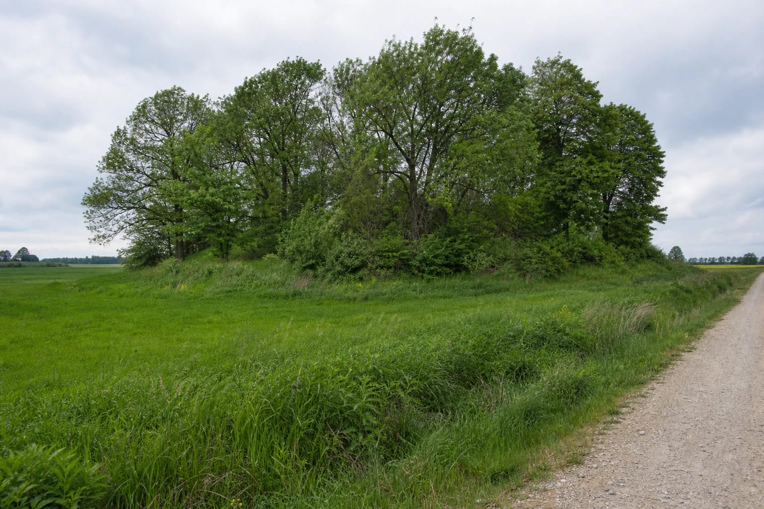
The same source warns that the direction signs stand away from the road, near the stream and at the foot of the hillfort, and can be almost invisible behind dense summer vegetation. A photograph taken from the gravel road in 2012 shows little more than a clump of trees beyond a green field. If no clear public path or sign is visible, do not drive into the field or cross crops merely because the map pin is only a short distance away.
The checked official sources document no dedicated car park, gate, stairs, toilet, lighting, or step-free path. They also publish no admission charge or official visitor schedule. Leave a vehicle only where doing so is legal and safe, never block the gravel road or a farm access, and do not present the site as wheelchair-accessible unless current conditions have been checked on the ground.
This is not a panoramic viewpoint or reconstructed castle, but a low wooded landform read through subtle changes in relief
Vainatrakis Hillfort is modest in scale. From the road it resembles a dense deciduous grove among cultivated fields, while summer brings shade, tall ground vegetation, shrubs, and fallen wood to the summit. The register's 2022 condition record mentions thinned trees, animal burrows, and dug pits. Visitors should not expect a broad panorama, rebuilt walls, or a clearly engineered visitor circuit.
Read the landform in sequence. First identify the low mound enclosed by the valleys of the Vyčius and Striaunė, then follow the southwest-to-northeast line of the summit, and finally look for the two ramparts and the deeper intervening ditch at the northeastern end. These transitions are easier to recognise without leaves; in summer, vegetation can fragment the shapes almost completely.
Allow approximately 30-60 minutes and visit only in daylight, preferably in dry weather. Wet grass and leaves, silted ditches, animal burrows, and old pits can create slippery and uneven ground. Use only a clear existing approach, protect the graves and archaeological surface, and treat the place as a quiet heritage and memorial site rather than a managed attraction.