- Place
- Šėtijai, Lekėčiai eldership, Šakiai District Municipality
- Region
- Suvalkija
- Type
- a state-protected hillfort of national significance with an earth rampart and ditch
- Address
- Šėtijai village, Lekėčiai eldership, Šakiai District Municipality
- Coordinates
- 55.00207, 23.58013
- Visit duration
- 35-60 minutes for the approach, enclosure, rampart, and ditch; allow longer in wet conditions or when the undergrowth is dense
- Best time
- a dry day in early spring or late autumn, when the rampart, ditch, and promontory are easiest to read through leafless trees
Jundakalnis, Šėtijų piliakalnis, Šėtijai Jundakalnis
A wooded promontory is framed by the Liekė, Lapupis, and the Nemunas valley
Šėtijai Hillfort was built on a promontory in the upland above the left bank of the Nemunas. The current Register of Cultural Property places the Liekė to the south, the Lapupis to the north, the Nemunas valley to the east, and the continuing upland to the west. This setting explains the defensive logic: deep valleys hindered access on three sides, while the western neck connecting the site to higher ground was reinforced with a rampart and ditch.
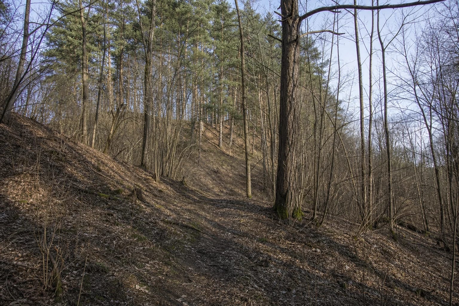
This is not an open grassy mound with a permanently clear panorama of the Nemunas. The register recorded the promontory, enclosure, and slopes as wooded in 2020, while photographs held with the record show pines, spruces, deciduous trees, and dense hazel growth. Foliage can hide the valley, so the character of Jundakalnis comes from the abrupt break in the terrain, the ravines, and earthworks that appear between the trees rather than from an uninterrupted horizon.
The Šakiai district plan lists Šėtijai Hillfort, register code 3274, among the important cultural tourism sites along the Panemunė corridor. It stresses the historical, aesthetic, and territorial context of this entire stretch. Jundakalnis is therefore not an isolated mound but one point in a long sequence of hillforts along the left bank of the Nemunas.
A 35 by 25 metre enclosure stands behind a western rampart and partly filled ditch
The valuable features updated in the register in 2020 describe an enclosure about 35 metres long from north to south and 25 metres wide. A rampart approximately 25 metres long and 12 metres wide crosses its western edge. It rises about one metre above the enclosure and two metres on the outer side, making the artificial line of defence easiest to recognise from the west.
A ditch about eight metres wide and 0.8 metres deep lies beyond the rampart. It is partly filled and overgrown with shrubs, while the rampart itself has been affected by erosion. The slopes above the streams and Nemunas valley are steep, rise to 35 metres, and are also eroding beneath trees. The registered property geometry covers 26,127 square metres, but there is no clearly visible 2.6-hectare boundary on the ground. The essential features are the edge of the enclosure, the rampart, the hollow of the ditch, and the slopes falling sharply away.
Petras Tarasenka's measurement of 23 September 1956 captured a different profile: an enclosure roughly 40 metres long and more than 40 metres wide, a rampart 45 metres long and over two metres high, and slopes of 42 metres. Those historical figures should not be merged into the current register plan. Surveys made at different times separated the natural promontory, enclosure, and rampart in different ways, while vegetation and erosion also changed the terrain. This page uses the register's 2020 valuable features to describe the site visitors encounter now.
The broad date range and unexcavated cultural deposit set clear limits on what is known
The register dates Šėtijai Hillfort broadly to the first millennium AD and the beginning of the second. This is an archaeological span, not the known lifespan of one precisely dated timber castle. Its bibliography includes the diary of Rimutė Rimantienė's survey expedition in 1960, but the current record explicitly labels the cultural deposit as unexcavated. Public evidence does not provide an excavated building plan, a closed assemblage of finds, or a particular destruction layer.
The property entered the register on 30 December 1998. Its former register code was A1489 and its present unique code is 3274. KVR classifies it as an individually protected state property of national significance. Archaeological value determines that significance, with landscape and mythological characteristics adding further value.
A modern study by Laurynas Kurila includes Šėtijai in an analysis of the defensive hillforts along the Nemunas. The author also warns that the network visible today combines sites occupied in different periods and cannot prove that all operated at once or formed a continuous chain of fire signals. An elevated position over the valley is therefore not evidence by itself that signal fires were relayed from Jundakalnis.
The name Jundakalnis preserves a folk account, while the Junigėda identification remains unproven
The register protects a folklore association as well as the earthwork. It records a story that a sacred place of the war goddess Junda once stood here and that, when enemies began attacking the land, the castle of the powerful noble Šėta occupied the hill before sinking into the ground at the command of the gods. The register documents the existence of this account; it does not turn Junda's sanctuary or the sunken castle into an archaeological fact.
Tarasenka repeated the nineteenth-century view of Aleksander Połujański, who considered Šėtijai a possible location of Junigėda Castle, mentioned in 1291 and destroyed in 1317. In the 2018 table of the Nemunas defensive line, however, Šėtijai has no historical castle assigned to it, while Junigėda is associated with the hillforts at Veliuona. The responsible conclusion is that identifying Šėtijai with Junigėda is an old hypothesis, not an established location.
The pair of names remains valuable without that certainty. Šėtijai Hillfort ties the monument to the present village, while Jundakalnis carries the memory of local storytelling and earlier descriptions. Both names belong here, but neither justifies inventing a precise deity, ruler, battle, or castle history that archaeology and the register do not confirm.
Use the exact pin, respect the nearby homestead, and read the earthworks before seeking a view
The exact Google place listing marks the hillfort at 55.002068, 23.5801255. An older official monument description places it about 550 metres south-west of the confluence of the Nemunas and Liekė and roughly 20 metres west of the road between Zapyškis and Mikytai. The Lithuanian hillfort atlas also approaches by the Pavilkijys to Zapyškis road, beyond a homestead and before the Liekė stream. Because signs and minor paths through undergrowth can change, use the exact pin for the final approach and do not cross an occupied yard.
A photograph hosted by KVR and dated 2018 shows a brown road sign pointing 0.2 kilometres towards Šėtijai Hillfort. It records the waymark at that date but cannot guarantee its present condition or visibility. The authoritative sources checked do not confirm a dedicated car park. Leave a vehicle only where current signs permit, without blocking the road or entering private land.
Look for the western rampart and the hollow of the ditch first, then move into the enclosure. In dense woodland these landforms say more about the hillfort than a chance glimpse between branches. Do not climb straight up the steep sides, dig, or disturb the rampart. The register already records erosion, so a shortcut damages the very feature the visit is meant to understand.
The 4.5 Google rating accompanies a site with no published schedule or confirmed visitor facilities
On 15 July 2026, the exact Google Maps listing Šėtijų piliakalnis, place ID ChIJu2tkz0fn5kYRjiWcey35V-E, averaged 4.5 out of 5 from 24 reviews. This meets the selection threshold exactly and rests on a more meaningful sample than listings with only one or two votes, although the average and review count will change over time.
The visitor information and opening-hours fields in KVR are empty, while the official sources checked publish no admission charge, ticket office, gate, or fixed visiting schedule. That does not imply lighting or a maintained route at night. A wooded, unfenced archaeological site is safest in daylight, in dry weather, and with firm footwear.
Reliable sources also do not confirm steps, handrails, toilets, or a step-free route. Eroding slopes up to 35 metres high, roots, leaf litter, shrubs, and a partly filled ditch mean the hillfort cannot be treated as reliably wheelchair accessible. Keep children away from slope edges, do not descend into the Liekė ravine after rain, and keep the group together on a visible path.