- Place
- Misviečiai, Šeimena eldership, Vilkaviškis District Municipality
- Region
- Suvalkija
- Type
- the hillfort component of a nationally significant archaeological complex with a settlement at its foot
- Address
- Misviečiai, LT-70375, Vilkaviškis District Municipality
- Coordinates
- 54.60839, 22.93688
- Visit duration
- 30-45 minutes to read the hillfort earthworks, excluding the walk from a lawful stopping place
- Best time
- a dry day in spring or early autumn, when low grass and thinner foliage make the bank easier to see and the Brideikis valley slopes are less slippery
Misviečių piliakalnis, Kapkiemis, Pilis, Misviečiai Hillfort and Settlement
The exact pin marks the hillfort, not a built visitor entrance
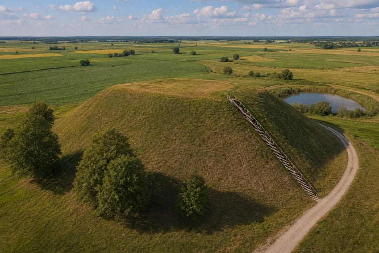
Misviečiai Hillfort lies west of the centre of Misviečiai village, on a spur above the right bank of the Brideikis. The exact Google Maps place is at 54.6083903, 22.9368843. This is a site point on the archaeological monument, not a car park, gate, or verified trailhead. The village address attached to the listing does not establish that a car may lawfully be driven all the way to the pin.
On 15 July 2026, the listing was named Misviečių piliakalnis, carried place ID ChIJlTyyAgA34UYR780fsLzGIx4, and averaged 5.0 out of 5. That score came from a single review. It formally clears the 4.5 selection threshold but is not a robust measure of popularity or visitor conditions, and every new rating can change it substantially.
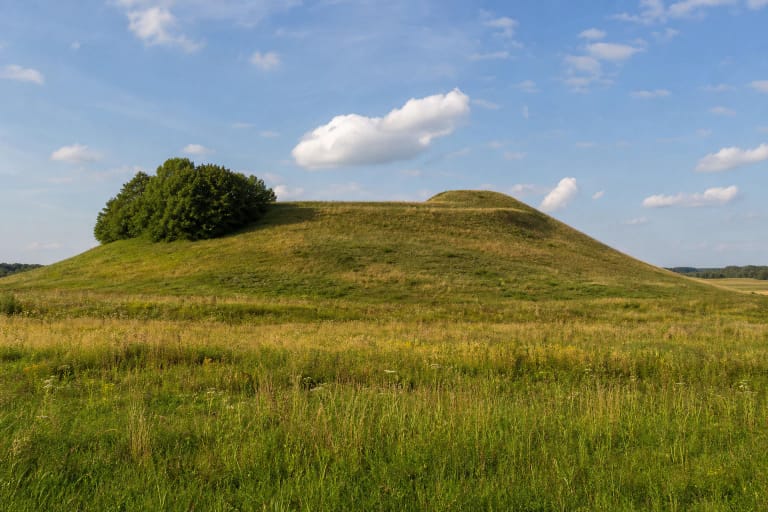
Register photographs from 2023 and an exact-site photograph from 2025 show an unlandscaped rural earthwork rather than a visitor park: rough grass, scattered scrub, denser deciduous growth on the slopes, and cultivated land at the eastern foot. A small roofed wooden panel in the photographs appears blank or illegible, so it should not be relied on as a functioning information board.
A 35-metre bank separates the 27 by 25 metre enclosure from the fields
The register describes a spur on the right bank of the Brideikis, enclosed by the stream's marshy valley to the northwest, west, and south. Its triangular enclosure runs almost east-west and measures about 27 metres by 25 metres. The eastern part stands up to 1.7 metres higher. Later earthworks, the former cemetery, and vegetation mean that the surface no longer reads as a geometrically level terrace.
A curved bank about 35 metres long crosses the eastern edge. It rises up to 1.6 metres above the enclosure, is 12-15 metres wide, and has an apparently levelled crest up to 3 metres across. The bank has spread and flattened and now carries scrub and small trees. It is therefore best read by looking across its line rather than by searching for a tall, separate mound.
The natural slopes are steep and about 12-14 metres high. The Brideikis has washed parts of them, while dense scrub and trees restrict views into the valley. This is not an open panoramic viewpoint. Its value lies in understanding how a modest earthwork used a marshy stream valley and the open land to the east.
Complex 22995 has two components whose areas and finds must not be merged
The Cultural Heritage Register calls the whole protected place Misviečiai Hillfort with Settlement and assigns it code 22995. The nationally significant monument consists of hillfort 3695 and settlement 22996. The current register dates the complex from the first millennium to the beginning of the second millennium CE and protects both its archaeological and landscape character. Its registered territory covers 14,792 square metres, with a 66,619-square-metre visual protection subzone.
Hillfort 3695 comprises the enclosure, bank, and slopes. Settlement 22996 lies at the eastern foot on comparatively level ground descending towards a small pond. The register records a dark cultural deposit up to 0.5 metres deep, but long-term ploughing has damaged its surface and cultivation continues. It does not appear to visitors as a separate village or an interpreted display.
Older descriptions assign the settlement an area of about 0.2 hectares, but the current register does not present this as the modern area of the separate component. It must not be confused with the 14,792 square metres now registered for the entire complex. The numbers belong to different levels and periods of heritage documentation.
A 1965 field survey, 1993 finds, and one very specific test pit in 2004
An Institute of History expedition inspected Misviečiai in 1965 during a survey of archaeological sites across Užnemunė. A later survey of the settlement in 1993 recorded pieces of daub, iron slag, and burnt stones at the eastern foot. These finds demonstrate human activity and burning, but slag and daub alone cannot identify a particular craft centre, ruler, or historically documented castle.
In 2004, when a site for a proposed information stand was being assessed, archaeologists opened one 1 by 1 metre test pit at the northern foot, about 12 metres north of the slope. Beneath 15-20 centimetres of turf and topsoil lay 25-30 centimetres of brown sandy loam grading into natural soil. No archaeologically valuable deposit or finds appeared in that particular square metre.
A negative result in one small test pit does not erase the settlement whose cultural deposit and artefacts were recorded elsewhere. It shows that archaeology is unevenly distributed around the foot. For the same reason, visitors must not dig, remove pottery noticed on the surface, use a metal detector, or drive across the registered area.
Kapkiemis and Pilis are names, while a former cemetery altered the enclosure
The official name of the hillfort component includes two traditional names, Kapkiemis and Pilis. They help identify the same place in older records and local memory, but they do not prove the survival of a masonry castle, a named garrison, or a documented battle. What can be seen today is an archaeological earthwork, not castle ruins.
The register records that a Misviečiai village cemetery used in the nineteenth and twentieth centuries disturbed the enclosure. The area is no longer being disturbed, lies fallow, and carries only scattered scrub. It is not a separate attraction or a confirmed active burial ground, but its history calls for respect: do not disturb soil, move stones, or search for supposed grave markers.
An older Vilkaviškis regional library account and photographs from 2004 mention a wooden cross that then stood on the bank. The current 2023 register description explicitly says the cross no longer exists. The little roofed wooden panel seen at the foot in recent photographs is a different object and must not be confused with that cross.
Visiting without a verified car park, path, or opening schedule
The official sources checked publish no admission charge, ticket office, gate, or permanent opening hours. They also do not verify a visitor car park, public road to the hillfort, toilet, benches, steps, handrails, or step-free route. This is an independently explored outdoor site, but that does not make every farm track public or suitable for a car.
Navigation may suggest agricultural tracks or routes along crops. Do not drive onto fields, across crops or meadows, or into private service drives. Leave a vehicle only where current signs permit it without blocking agricultural access, and walk the remaining distance on an existing track or field edge. Because parcel ownership and a formal approach were not authoritatively resolved, obey signs and any request not to enter.
Choose dry weather and daylight, and wear waterproof footwear with a good grip. The Brideikis valley can be wet, the slopes are steep and overgrown, and the cultivated settlement surface becomes muddy after rain. Allow about 30-45 minutes on the earthwork itself. Kaupiškiai, Piliūnai, and Vištytis Hillforts show very different forms of the same district's archaeological landscape and make more suitable additions than treating Misviečiai as a long standalone attraction.