- Place
- Juodkrantė, Neringa Municipality
- Region
- Curonian Spit
- Type
- passenger landing with a publicly approachable quay apron
- Address
- L. Rėzos g. 1D, Juodkrantė, Neringa
- Coordinates
- 55.54199, 21.12273
- Visit duration
- 20-45 minutes for the pier and lagoon panorama; a boat trip follows the selected operator's timetable
- Best time
- on a calm day in daylight; for a passenger sailing, only after checking the seasonal timetable, tickets, and weather conditions
Juodkrantės prieplauka, Juodkrantė passenger pier, Šiaurinė prieplauka
Which pier the map card identifies
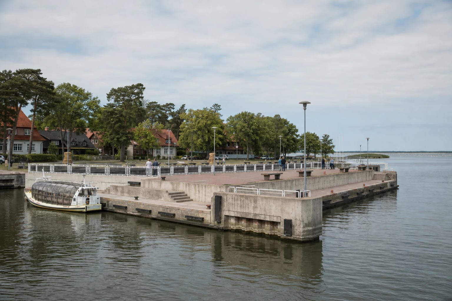
The exact Google Maps card named Juodkrantės prieplauka identifies the central passenger landing at L. Rėzos g. 1D. A broad concrete apron projects from the shore, with landing levels at different heights, steps, pale metal railings along exposed edges, lamps, benches, mooring rings, and fenders. This is a Curonian Lagoon pier, not a Baltic Sea pier, so the low eastern lagoon shore is visible on the horizon instead of the open sea.
A Curonian Lagoon navigation study published in 2022 recorded a depth of 2.5-3 m here, together with a quay, lighting, a small slipway, and mooring equipment. Those observations describe conditions at the time of the study; they do not guarantee today's depth or an available berth. Detailed-planning material gives 2,687 sq m as the area of the entire existing passenger-harbour plot, including its quay and car park, so that figure must not be treated as the deck area of the pier alone.
The long lagoon promenade and Juodkrantė waterfront park, laid out in 2001, form a much larger public space. The pier is the specific navigation point at its centre. Official operator Forelle labels the same location Šiaurinė prieplauka, or Northern Pier, in its directions, but its link opens this same Google Maps card rather than Amber Bay.
The 1880 pier and its lost waiting hall
The Curonian Spit National Park's architectural study states that the government built the pier in 1880, using material dredged during amber mining for its earth fill. The amber company contributed 2,000 marks, while hotel owners E. Stellmacher and Stremkus each gave 1,000 marks. The landing made it easier for steamships to bring passengers and goods into the growing resort of Juodkrantė.
In 1891, a passenger waiting hall facing south was built at the end of the pier with money donated by summer visitors. An avenue of chestnuts, birches, and maples led from it towards the village. These facts describe the historic landing, but they do not date every concrete element visible today.
Municipal planning documents explain that the site's present configuration has been altered and enlarged, its former earth-fill structures replaced by concrete quay walls, and the old waiting hall lost. Its precise location has not been established reliably, so the documents require archaeological investigation before the proposed reconstruction.
Passenger sailings and the harbour that has not been built
In 2026, official operators published two seasonal connections using the Juodkrantė landing. Forelle linked Klaipėda and Juodkrantė, while the Dreverna ferry crossed between Juodkrantė and Dreverna on the opposite lagoon shore. The presence of a pier does not itself mean that a service will operate on a given day: the carrier assesses the season, passenger numbers, weather, and navigation conditions.
On 14 July 2026, Forelle advertised Saturday sailings in May, weekend sailings in June, daily sailings in July and August, and Saturday sailings in September. The published plan departed Klaipėda at 10:30, reached Juodkrantė at 12:30, and left Juodkrantė at 16:00; a passenger aged 12 or over paid €15 one way or €29 return. These are the operator's timetable and fare, not the pier's opening hours or an admission charge.
The Dreverna operator advertised its 2026 season from 19 June. Monday to Thursday departures from Juodkrantė were listed at 10:45, 16:45, and 18:45; on Fridays, weekends, and public holidays, a 12:45 sailing was added and the 16:45 departure moved to 17:45. The adult one-way fare was €11. Check the official operator page for that day's timetable, availability, and changes before setting out.
A new Juodkrantė harbour is planned north of the existing passenger pier, with a separate basin and space for roughly 80 boats. On 27 March 2026, the municipality said it was working towards a building permit but that the investment project had not yet been approved. The planned marina, yacht club, new piers, and possible future routes are therefore not operating services of the present passenger landing.
The waterfront, other piers, and safe behaviour
Amber Bay farther north is a separate historic basin with a pontoon landing intended for fishermen. Ąžuolynas Pier in the southern part of the settlement is another structure, a mole projecting into the Curonian Lagoon and turning north at its outer end. Neither place's coordinates, functions, nor map rating are used on this page.
You can approach the central pier on foot from Juodkrantė's waterfront, and no separate sightseeing ticket or museum-style opening hours are published. The vessel edge is nevertheless a working area. Follow crew instructions during boarding, do not cross temporary barriers, and never stand on mooring lines or between a vessel and the quay.
There are changes in level, steps, and sections of open quay edge beside the water. Keep children close, do not sit on railings, and avoid wet or icy concrete in strong winds. This is not a bathing place. Take photographs from a stable part of the apron and leave the passenger and crew route clear.
Accessibility and a short visit plan
The main quay apron is approached over a hard, mostly level promenade surface. Lower landing levels have steps, however, and access onto a vessel depends on its gangway, the water level, and the individual operator's equipment. A fully step-free journey should not be promised without confirmation; discuss mobility needs with the carrier before buying a ticket.
In calm weather, allow 20-45 minutes for the pier and lagoon panorama. A longer walk can continue north along the waterfront towards Amber Bay or turn inland to the Hill of Witches and the older resort quarter of Juodkrantė. In summer, arrive before the operator's stated boarding time but keep the working area clear until the crew calls passengers forward.
The Google Maps point marks the pier site itself, not a guaranteed parking space or a particular boarding gate. Navigate to L. Rėzos g. 1D, then confirm the meeting point, ticket check, and any baggage or bicycle conditions in the information for your chosen sailing.