- Place
- Neringa Municipality
- Region
- Neringa
- Type
- 1.6 km historic forest-promenade and plant-discovery route across old parabolic dunes
- Address
- Gintaro Įlankos g., Juodkrantė, Neringa
- Coordinates
- 55.55045, 21.12182
Dendrological Educational Trail in Juodkrantė, Educational Dendrological Trail, Blocksberg Promenade
A 1.6 km trail easily confused with a 6 km route
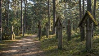
The official Juodkrantė dendrological trail is a 1.6 km linear route. Its northern end lies in the forest by Amber Bay, across the main road, and its southern end reaches the old Juodkrantė cemetery. The one-way walk normally takes about an hour, while returning along the same path increases the total to approximately 3.2 km.
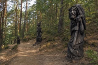
The same forest network now carries a marked 6 km loop called Along the Paths of the Forest Cathedral. Much of the older dendrological trail overlaps it, so a junction can unexpectedly send you towards Blocksberg, the lighthouse, the Hill of Witches, and other locations on the longer circuit. Photograph the map at the first board and keep following the symbols for your chosen route.
The short route is not a boardwalk or a level park path. Its surface is mostly natural, sandy in places, and crossed by roots, while dune relief creates gradients; lower points may become damp and slippery after rain.
From the Blocksberg Promenade to an educational trail
As Juodkrantė developed into a resort in the second half of the 19th century, a network of forest promenades was created around the settlement. Walking in shade was not a peripheral activity but part of the resort experience, combining old forest, dune relief, and valleys sheltered from the wind.
Today's 1.6 km line was formerly called the Blocksberg Promenade. Official park sources emphasise the deciduous trees planted along it - oaks, lindens, common maples, and red maples - whose shade and colour differed from the predominant conifers.
National-park naturalists later turned the promenade into a dendrological trail, with forestry workers assuming its maintenance. It therefore has two equally important layers: a remnant of an old resort landscape and a place to observe how different trees adapt to a windy, sandy peninsula.
An old forest growing on parabolic dunes
The hills along the trail are not continental moraine. The path crosses forested parabolic dunes, old horseshoe-shaped sand masses later stabilised by grasses, shrubs, and trees. The Universal Lithuanian Encyclopedia dates the beginning of the Curonian Spit's formation to about 5,000 years ago and identifies western Juodkrantė as Lithuania's largest surviving parabolic-dune massif.
Pine and spruce predominate, but deciduous trees produce a denser, damper, and more colourful setting than the spit's open sand. Steep slopes alternate with hollows, moss covers old roots, and trees of different ages reveal a more complex forest community than a uniform planted pine stand.
Roots matter here for more than appearance. Vegetation reduces the effects of wind and rain on sand, so a shortcut down a steep bank is not harmless: trampling breaks the surface that helps the dune retain its shape.
What can still be learned about trees
The earlier interpretation was structured as 16 stops. It introduced sycamore maple, black alder, common oak, European silver fir, spruce, pine, barberry, horse chestnut, alder buckthorn, northern red oak, small-leaved linden, honeysuckle, elder, birch, rowan, and hornbeam, together with a stop explaining a tree's life story.
Its best-known features were a ring of twelve red oaks and the site of the Griekų Linden. Legends recall an enormous old linden, but the tree itself no longer survives; a young linden was planted at the location, so visitors should not expect a giant natural monument.
When Juodkrantė's forest routes were renewed, many old species panels were removed or replaced and the short trail became part of the longer Forest Cathedral circuit. Older official documents still map 16 stops, but in 2026 do not plan around finding a complete 16-panel display. A plant-identification app or field guide now makes independent observation more reliable.
How to make the walk genuinely dendrological
In spring, compare bud and young-leaf shapes; in summer, crown density and shade; and in early autumn, each species' colour change. Winter invites identification through bark, branching, persistent fruit, and buds, although the task is much harder without leaves.
With children, choose four clues: leaf, bark, fruit, and position on a slope or in a hollow. Instead of rushing between boards, find one conifer and one broadleaf, compare the ground beneath them, count different bark surfaces, and photograph only the unknown species for later identification.
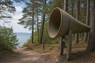
The Sound Catcher beside the route was renewed in 2026 and wayfinding signs help locate it. It is a separate acoustic object covered on the Amber Bay page; its simplest lesson on this walk is to stop for several minutes and hear how wind moves differently through needles and broad leaves.
Ticket, trailhead, and responsible access
There is no compulsory separate trail ticket, no gate, and no published opening schedule. The Curonian Spit National Park visitor ticket is a voluntary contribution: in 2026 it costs €1 for a single ticket, €5 for 30 days, or €25 annually for all state parks. Ferry, vehicle-entry, and local Neringa charges are separate.
The official location is 55.550455, 21.121815. Amber Bay and its bus stop are the easiest landmarks, but cars must be left only in a legal marked space and seasonal parking arrangements may change. At the cemetery end, continue towards central Juodkrantė or return through the forest.
Natural ground, roots, sand, and dune gradients mean the route is not reliably suitable for wheelchairs or anyone requiring a level hard surface. Walk in daylight with closed, grippy footwear, and postpone the route after a storm or in strong wind because of falling-branch risk.
Stay on the marked path, do not disturb moss, pick plants, or light a fire. In warm months use tick precautions and inspect clothing and skin afterwards; carry all litter out.