- Place
- Vilkaviškis District Municipality
- Region
- Suvalkija
- Type
- small timber viewing deck on a wooded Lake Vištytis slope, without a tower
- Address
- Šilelis Forest near Pakalniai village, Vištytis eldership, Vilkaviškis District
- Coordinates
- 54.39662, 22.77235
- Visit duration
- 20-40 minutes at the viewpoint itself; about 2.5 hours on the official 3.4 km long circuit of Šilelis Nature Trail
- Best time
- a clear, dry morning from late spring to autumn, when the opposite forested shore is well lit; Rominta Forest is most colourful in autumn
Regykla prie slidininkų trasos, Regykla Vaizdas į Romintos girią, Žvilgsnis į Romintą, Lake Vištytis Viewpoint
Three names identify the same small timber deck, not an observation tower
The Google Maps entry calls this site Regykla prie slidininkų trasos, or Viewpoint by the Ski Slope, and places it at 54.396623, 22.77235. Saugoma.lt uses the name View of Rominta Forest and the nearly identical point 54.396588, 22.7724, while the current Vilkaviškis tourism page describes a viewpoint at the former ski runs. The Environment Ministry panorama list records the same attraction at LKS-94 coordinates 420271, 6029560. These are names for one place, not separate viewpoints.
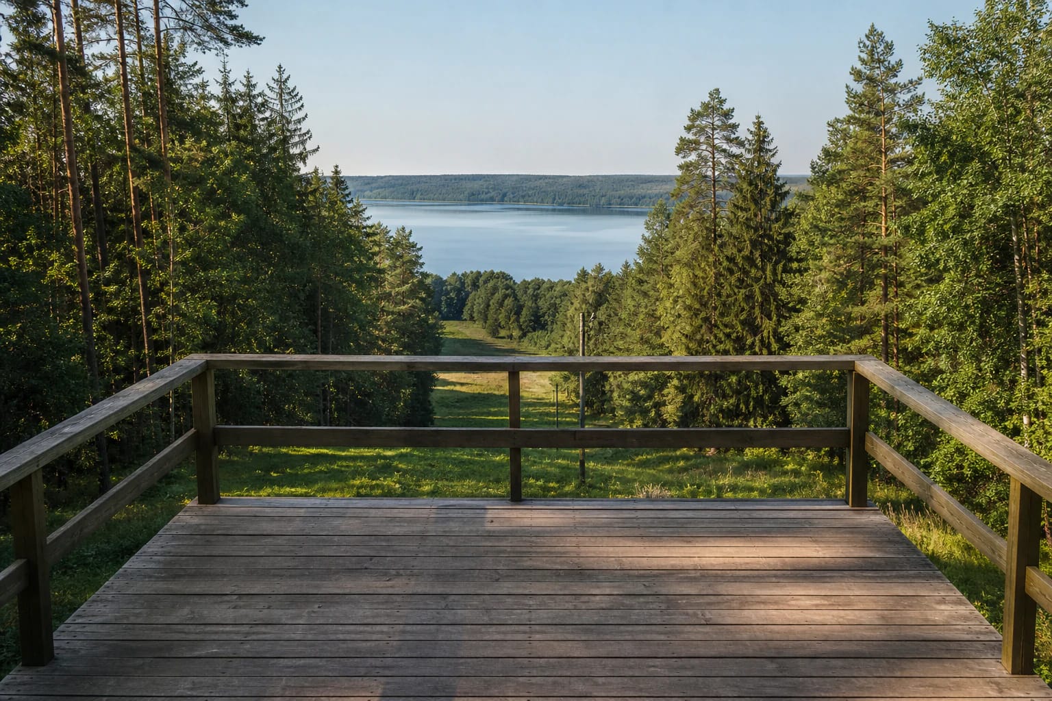
Official Saugoma.lt photographs show a small rectangular deck of timber boards rather than a tall structure. A simple wooden railing encloses its three open edges, and the front faces the slope and lake. The deck has no roof, enclosed cabin, or multi-level staircase. All of its viewing height comes from the steep natural shore relief.
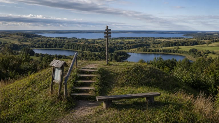
The platform occupies a window in the forest. Pine, spruce, and deciduous trees frame both sides, while a more open grassy corridor falls away below. This is therefore not a 360-degree panorama. The main sightline runs in one direction, across the water of Lake Vištytis towards the distant belt of forest.
Lake Vištytis fills the foreground, while the far wooded shore belongs to the Rominta landscape
The first element visible from the deck is Lake Vištytis enclosed by dense trees. The water can look narrower from this angle because the crowns on the near shore hide its edges, but the central band and opposite shore remain clear. Morning often gives the best landscape detail because the sun is behind the visitor and lights the western forest wall; evening can place bright glare directly over the lake.
The dark horizon beyond the water is the direction of Rominta Forest. VLE gives the roughly 37,000 ha forest a 57 percent share in Russia's Kaliningrad Region and a 43 percent share in Poland's Warmian-Masurian Voivodeship; its eastern edge below Lake Vištytis joins Lithuania's Pavištytis Forest. The forested opposite shore seen from the platform is an international border landscape, not a separate Lithuanian wood a short walk away.
This viewpoint presents one large lake and one distant forest massif. It is not Three Lakes Viewpoint, where visitors must identify the smaller Lakes Grabauskas and Pakalniai as well, and it is not the plateau of Pavištytis Hillfort. All three attractions lie in the same regional park, but they have separate coordinates, different visitor structures, and different foregrounds.
The former ski corridor reveals the steep glacial slope above the lake
Ski slope remains in the name because a steep clearing descends from the platform towards the lake. The official Šilelis trail description says that shore slopes around Lake Vištytis rise by as much as 50 m in places. This is a figure for the wider shoreline, not a measured height of the deck, but the abrupt drop is easy to understand here without crossing the railing.
High moraine hills and Lake Vištytis in its inter-ridge basin form the central protected landscape of the regional park. Glacial ice did more than leave a lake hollow: it pushed up steep ridges, which is why this narrow opening creates far more depth than a viewpoint on a level shore. Trees in the foreground provide a useful scale for the descent.
The current Vilkaviškis tourism page calls these former ski runs, while the official park sources reviewed in 2026 publish no operating lift, ski hire, piste report, ticket price, or winter timetable. The Google name preserves local memory but does not confirm a functioning ski centre. Anyone intending to ski must separately verify a current operator and snow conditions rather than relying on the viewpoint listing.
The reliable official approach follows the 3.4 km long loop of Šilelis Nature Trail
The official Vištytis Regional Park description includes the viewpoint on Šilelis Nature Trail. This circular route starts and finishes at an information board beside the Vištytis-Vyžainis road. At the Holy Spring the trail divides: the short loop is 2.4 km and takes about 1.5 hours, while the long route that includes the viewpoint is 3.4 km and is allotted about 2.5 hours.
Round markers bearing a tree symbol show the route. The long loop also passes the Šilelis suffosion cirque, wooded shore slopes, hollow trees, and other interpretation stops, so 2.5 hours is not simply the time needed to climb to the deck. If you are already nearby, 20-40 minutes is enough for the platform itself, but an unmarked shortcut through the forest should not automatically be treated as a public visitor route.
The Google pin and addresses on Poilsiautojų Street can create the impression that a car can reach the platform. The official trail page confirms neither drive-up access nor a dedicated car park beside the deck, and it does not authorise vehicles on forest tracks. The safer plan is to use the marked trailhead, follow current signs, and park only where clearly permitted without blocking the road or access to private holiday cabins.
A 2025 management record confirms the attraction remains in use but does not date this particular deck
Minutes of the Vištytis joint council meeting held by the Dzūkija-Suvalkija Protected Areas Directorate on 2 December 2025 list View of Rominta Forest as one of the visitor-adapted sites included in a field visit. The same document discusses mowing, litter collection, and renewal of worn timber elements at the park's five viewpoints, nature trails, and other recreation sites. This is the clearest recent official evidence that the attraction remains part of the park's visitor infrastructure.
The record notes that most of the park's timber infrastructure was installed as early as 2008. It does not state that this specific platform was built in that year, so 2008 cannot be presented as a confirmed construction date for the viewpoint. Saugoma.lt photographs establish the deck's form, while every visitor still needs to assess the current condition of boards and rails on arrival.
Before stepping onto it, look for a closure barrier, broken plank, protruding nail, or visibly loose railing. Wet timber can be slippery after rain and in autumn, while ice and snow collect on the boards in winter. The rail is a safety boundary, so do not climb over it or descend straight down the steep former ski corridor.
Google lists 24-hour access, but this is neither a lit nor a staffed attraction
On 15 July 2026, the Google Maps entry listed the viewpoint as open 24 hours and showed an average of 4.8 out of 5 from 6 reviews. The official object and trail pages publish no separate admission ticket or staff timetable. A map listing for an outdoor site does not, however, promise lighting, a daily inspection of the boards, a cleared path, or an attendant.
Daylight matters for both the panorama and safety on a forest trail. Grippy footwear, drinking water, tick-aware clothing, and a charged phone matter more here than they would at an urban lookout. The 2025 council record only discusses a seasonal need for portable toilets and waste containers at the Šilelis trailhead, so neither a toilet nor other services should be treated as guaranteed.
The official sources do not confirm a level hard-surfaced approach, ramp, or universally accessible deck. Forest ground, the longer walking route, and potentially slippery timber may prevent wheelchair access or create difficulties for visitors with limited mobility. With children, stay on the marked trail, never cross the railing, and check the latest park information before making a special journey.