- Place
- Balkasodis, Miroslavas eldership, Alytus District Municipality
- Region
- Dzūkija
- Type
- the nationally significant hillfort component, with legal monument status, of a state-protected archaeological complex with a settlement
- Address
- current register: Balkasodis village, Miroslavas eldership; Alytus District visitor-site list: Dirmiškiai village, Miroslavas eldership
- Coordinates
- 54.27695, 23.93267
- Visit duration
- 30-60 minutes to examine the hillfort relief and its foot, excluding the unverified approach
- Best time
- a dry leafless day in early spring or late autumn, when the ring bank is easiest to read in the forest and its mossy slopes are not wet
Dirmiškių piliakalnis, Strumpakalnis, Dzirmiškių piliakalnis, Dirmiškių piliakalnio su gyvenviete piliakalnis, vad. Strumpakalniu
The name Strumpakalnis links the register's Balkasodis address with the municipality's Dirmiškiai
The Cultural Heritage Register names complex 31920 Dirmiškiai Hillfort with Settlement. Its hillfort component 1851 is Dirmiškiai Hillfort, also called Strumpakalnis. The current register assigns both to Balkasodis village in Miroslavas eldership, while Alytus District's current visitor-site list places the same complex 31920 in Dirmiškiai village. This is a difference between official address fields, not two hillforts with the same name.
The exact Google Maps coordinates are 54.2769471, 23.9326736. The listing carries place ID ChIJ5d5lycS74EYRiMzev8ykcm8 and CID 8030662284854348936, but displays only postcode 64238 and Alytus District Municipality as its address. The pin lies on the archaeological monument itself and must not be treated as an entrance, car park, or verified trailhead.
On 15 July 2026, the Google Maps average was 5.0 out of 5 from two reviews. This clears the 4.5 threshold, but two ratings remain a very small and volatile sample. One new review could change the average sharply, and the score establishes nothing about lawful access.
The current 7 by 5 metre enclosure sits inside a broad ring bank
The hillfort occupies a small projection of higher ground into the valley of an unnamed stream and adjoining marsh. VLE places the stream to the south and marshy ground to the west. The current register describes the enclosure as oval, elongated north-south, and only 7 by 5 metres. From the foot, the body of the bank is therefore far more prominent than the tiny interior.
VLE gives an older enclosure measurement of roughly 10 by 6 metres. The current 7 by 5 metre register figure and the older 10 by 6 metre encyclopaedic figure should not be averaged. The sources do not explain whether their difference reflects measurement technique, the definition of the enclosure edge, or a change in the relief, so it cannot be presented as proof that the summit physically shrank between surveys.
A stone-reinforced bank encloses the summit on every side. It stands 2-5 metres high and measures 10-24 metres wide, with an outer face up to 7 metres high. The steep natural slopes can also reach 7 metres. Two pits cut the northern slope. Stones belong to the bank's construction, but there is no exposed stone wall or masonry castle on the site.
The cultural deposits on the hillfort and in the settlement are registered separately
The register records a dark sandy cultural deposit up to 0.6 metres deep on the hillfort enclosure, first observed during a 1954 survey. Roots from trees that formerly grew there have disturbed it. Settlement component 31921 lies west of the hillfort beyond marshy ground, on the edge of the neighbouring rise as it climbs gently westward.
The settlement's current record describes a 60-75 centimetre dark deposit containing charcoal and archaeological finds, disturbed by roots and earlier ploughing. In 2001, Arūnas Puškorius opened three test trenches about 70 metres west-southwest of the hillfort, covering 12 square metres in total. Only one trench contained a clear cultural deposit, which led the excavator to recommend wider evaluation to establish the settlement's extent.
The primary 2001 ATL publication explicitly lists hand-built pottery with striated and smooth surfaces and several flint flakes. Its lower excavated horizon contained only striated pottery, while smooth-surfaced pottery occurred above. VLE's later summary additionally mentions rough-surfaced pottery and gives a deposit depth of about 0.85 metres. The current register's 60-75 centimetres and VLE's 0.85 metres may reflect different measurement points or later summarising, but the sources do not explain the discrepancy, so the figures remain separate.
The complex begins at the end of the first millennium BCE, while Švedkapiai is a separate site
The register dates the complex, hillfort, and settlement from the end of the first millennium BCE through the first millennium CE. The primary 2001 ATL publication gave the settlement finds a wider range spanning the first millennium BCE and first millennium CE. Complex 31920 is state-protected and nationally significant, hillfort component 1851 has legal monument status, and settlement 31921 is state-protected. The registered complex covers 29,615 square metres, or about 2.96 hectares, with a 135,766-square-metre visual protection subzone.
The Dirmiškiai burial-mound cemetery called Švedkapiai has its own register code, 1852, and does not form part of hillfort-and-settlement complex 31920. The current complex record places it about 0.1 kilometres northwest; the older VLE account and an earlier official monument list give roughly 0.30 kilometres. Those sources do not state matching reference points, so neither number is a turn-by-turn access instruction.
VLE assigns two uncremated burials excavated in 1988-1989 to the cemetery, together with two iron spearheads, a tanged knife, two pairs of spurs, and a clay cup. The burial mounds were dated to the third and fourth centuries CE. These grave goods are not finds from the hillfort or its settlement. The municipal list likewise gives complex 31920 and cemetery 1852 separate entries.
The krivis, vaidilutė, destroyed city, and Swedish door belong to different tales
The register preserves a tale about the love and marriage of a krivis, a pagan priest, and a vaidilutė, a temple maiden, followed by divine punishment that sank the lovers into the hill. Another story says that people raised the hillfort over the dead krivis's grave. These are related but distinct strands of folklore, not a documented biography or an archaeologically identified burial.
People also told of many residents of a city once standing here who were buried in the hill after invaders from the south destroyed it. A different tale links the mound with wars against the Swedes and claims that a door once stood on its northeastern side. The official archaeological records identify neither a destroyed city's name, a Swedish-period fortification, nor a recovered door.
The register treats mythological character as an important part of the complex's cultural significance. That protects the tradition of stories attached to the place; it does not certify every event in those stories as history. A careful visit keeps the real stone-reinforced earthwork and the tales of the krivis in view without substituting one for the other.
Tree clearance revealed the bank, but planned work is not a guarantee of visitor access
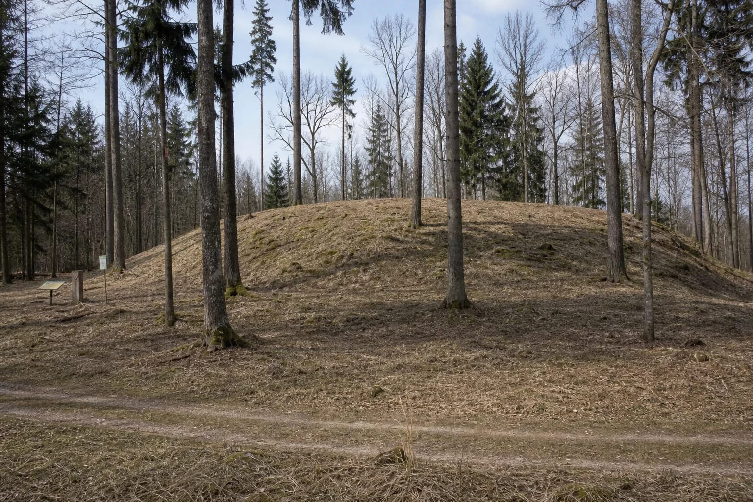
Register photographs from 2006-2007 show trees and shrubs heavily obscuring the slopes and enclosure. Images from 2019-2020, after clearance, show a much more open rounded bank covered with grass and moss, several isolated trees, a forest track, and two small signs at the foot. They show no steps. These photographs establish conditions when they were taken, not a guarantee that the signs or track remained unchanged in 2026.
On 5 March 2025, Alytus District Municipality announced plans for landscape-forming clearance and mowing at Dirmiškiai Hillfort and the burial mounds as part of an international Yotvingian route. The notice described future work, and no separate verified completion report was found. The project must therefore not be presented as finished or the planned route as currently operational.
The register's visitor-information and opening-hours fields are empty, while inclusion on the municipal visitor-site list does not confirm a car park, final public approach, admission charge, free-access policy, toilet, or step-free route. Check the latest municipal information before travelling, leave a vehicle only where parking is lawful, and do not drive along a forest track merely because a map pin is visible. If a lawful approach is clear on the day, visit in dry daylight, watch for the two pits on the northern slope, marshy ground, and slippery moss, avoid climbing straight across the bank, and never disturb stones visible in its surface.