- Place
- Marijampolė, Marijampolė Municipality
- Region
- Suvalkija
- Type
- state-protected archaeological complex comprising a hillfort, settlement, and prehistoric cremation burial area
- Address
- Karklų Street, Marijampolė
- Coordinates
- 54.54704, 23.33267
- Visit duration
- 30-60 minutes to understand the surviving hillfort, the Šešupė valley, and the scale of the archaeological complex
- Best time
- a dry day in spring or early autumn, when grass is low and the riverbank relief is easiest to read; the edge can be slippery after rain and in winter
Meškučių piliakalnis, Marijampolė Hillfort, Marcinkalnis, Kapsukas-Meškučiai Hillfort, Meškučiai Hillfort and Settlement
The map pin marks the surviving hillfort, not a dedicated visitor entrance
Meškučiai Hillfort stands on the southwestern edge of Marijampolė, on the left bank of the Šešupė beside Karklų Street. The exact site point is 54.5470381, 23.3326664. It marks the archaeological remnant on the riverbank, not a car park or built entrance. Neither the heritage record nor the municipality publishes dedicated visitor facilities here, so park only where this is lawful on a public street and never drive across meadow or protected ground.
The heritage register calls the whole complex Marijampolė-Meškučiai Hillfort and Settlement, code 33188, and also records Marcinkalnis as a name of the hillfort itself, code 5080. Some popular accounts instead apply Marcinkalnis to a nearby feature known as Meškučiai II. This page follows the official register: Marcinkalnis is an alternative name for the main protected hillfort, while Meškučiai II is another nearby landform and not the pin used here.
On 15 July 2026, the exact Google Maps listing named Meškučių piliakalnis averaged 4.5 out of 5 from 61 reviews. The score meets the selection threshold, but this is not a landscaped panoramic viewpoint. Its importance lies in the landscape shaped by the Šešupė and in archaeology preserved below the surface. Anyone expecting a symmetrical hill with a staircase may initially mistake it for an ordinary river bluff.
The Šešupė left a northern remnant roughly 100 metres long
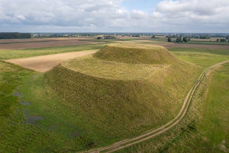
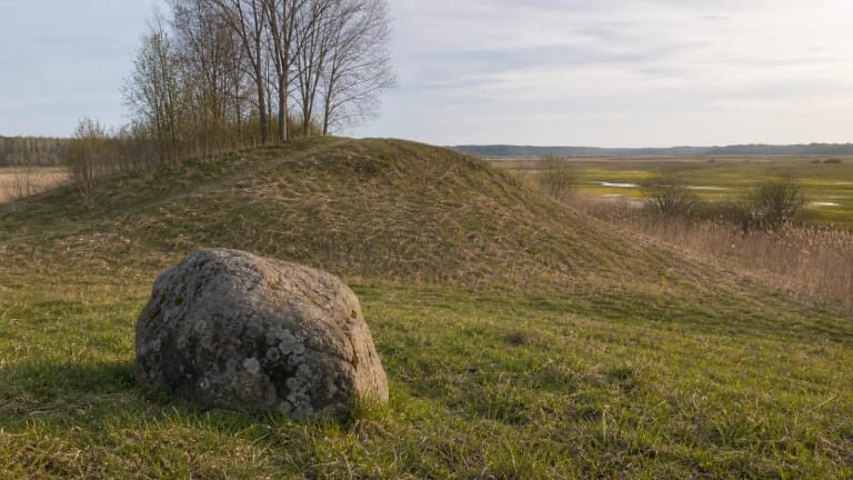
The fort occupied a spur of high ground on the left bank of the Šešupė. The current heritage record states that the surviving northern portion runs roughly 100 metres east-west, reaches up to 25 metres wide at its eastern end, and has slopes 4-15 metres high. The river carried away most of the southern portion, leaving an elongated grassy edge, exposed soil, and a steep descent rather than a complete enclosure encircled by obvious ramparts.
Twentieth-century investigators already encountered a badly damaged site. Petras Tarasenka described only a narrow edge of the enclosure in 1956, and Vytautas Daugudis excavated small surviving areas in 1968. Published measurements differ largely because they do not measure the same feature: some describe the surviving enclosure, others the entire riverbank remnant. On site, the useful question is not where a perfect mound has gone, but how the present erosion line became part of the monument's history.
Erosion is not merely a past event. Keep well back from the bluff after heavy rain, spring thaw, or frost, and do not descend over loose exposed soil. Grass and scrub bind the surface, while shortcuts and vehicle ruts damage the archaeological deposit. Keep children close and look over the valley from firm, level ground rather than an overhanging lip.
Two cultural horizons preserve structures and defences, not one castle standing for a thousand years
An expedition led by Vytautas Daugudis investigated the main hillfort in 1968, and Gintautas Zabiela examined an additional small area in 1994. The current heritage record defines a cultural deposit 70-100 centimetres thick with two horizons. The later, upper horizon contains burnt clay, fragments of stone paving, and remains of timber defences; the earlier horizon consists of dark grey, charcoal-rich soil with artefacts. An older research synthesis records depths of up to 1.5 metres in individual trenches, so the figures reflect particular cuts and the register's later summary rather than a simple contradiction.
Excavation produced roughened and smooth hand-built pottery, animal bone, a bone awl, part of a perforated stone axe, and a flint blade. Stone paving, burnt daub, and traces of timber construction demonstrate a genuinely built and fire-affected site, not a natural hill labelled a hillfort only by folklore. The limited area opened, however, cannot reveal a complete defensive plan or the number of buildings that stood on the spur at any one time.
The register gives the hillfort the broad date first millennium BCE to the beginning of the second millennium CE. This range represents several phases of use, not a single castle operating without interruption. Reliable sources provide no historical castle name, named ruler, or battle fought here, and they do not justify assigning every layer automatically to one Baltic people. Meškučiai matters because of measured deposits, not an invented heroic episode.
The settlement began earlier than the surviving riverbank fort might suggest
In 2006, evaluation ahead of proposed road and bridge work identified a previously unknown part of an unenclosed settlement northeast of the hillfort. Archaeologists excavated 531.2 square metres on the first terrace above the floodplain in 2007-2008 and a further 685.64 square metres in 2009. They exposed the channel of an old stream, hearths, stone paving and stone concentrations, postholes, and cultural deposits from more than one period.
The lower horizon distinguished in 2007 was dated to the second millennium BCE and contained smooth hand-built pottery, flint blades, and postholes. The upper deposit belonged to the first half of the first millennium CE and preserved a hearth, paving, roughened and smooth pottery, a blue glass bead, clay spindle whorl, narrow bronze band bracelet, and iron awl. These are traces of homes and craft activity rather than a refuge used only in emergencies.
The heritage register summarises the settlement deposit as 0.2-1.4 metres thick and dates the whole body of evidence from the second millennium BCE to the beginning of the second millennium CE. Such a wide bracket combines horizons found in different areas and isolated later material; it does not prove continuous occupation of one homestead. Ploughing and land drainage damaged parts of the deposit, so protected archaeology extends beyond the visible hillfort edge under apparently ordinary meadow.
Cremated human bone identifies a burial area, not a proven temple legend
Small fragments of cremated human bone appeared in many trenches opened across the settlement in 2009. One trench contained a 4.3-by-2.12-metre pyre site with a burnt layer up to 18 centimetres thick, bones, hand-built pottery, and stones; elsewhere, charcoal and cremated bone surrounded a small clay cup. The excavators provisionally dated the evidence to the second half of the first millennium BCE and concluded that human remains were cremated and collectively buried here.
The burial evidence came from the unenclosed settlement area, not the summit of the surviving hillfort. Bone, a cup, and pyre remains document specific funerary acts, but reveal no deity's name, priesthood, or temple plan. None appears in the excavation report, so online claims describing a named cult centre should be treated as modern speculation rather than an archaeological result.
The heritage record, excavation publications, and Petras Tarasenka's account provide no securely recorded traditional legend specific to Meškučiai Hillfort. That does not prove local people never told stories about the place, but no particular plot should be presented as inherited tradition without a source. The documented site is exceptional enough: an eroding fort, Bronze and Iron Age settlement horizons, and a recognised cremation burial area occupy one riverside landscape.
Visit in daylight and prepare for an undeveloped riverbank
The heritage register and municipality publish no admission charge, gate, or formal opening schedule. Google labels the place open around the clock, but that is not an official visitor regulation. Daylight is the safest time to visit. Check municipal notices, the map, and any signs on site again before travelling, especially after flooding or conservation work.
No confirmed paved car park, level path, stairs, or handrails serve the hillfort. The final approach may be grassy, muddy, and difficult to identify, and navigation software may suggest an unsuitable vehicle route. Wear shoes with good grip, avoid blocking Karklų Street or residents' entrances, and never follow a car route across a field. The steep natural slope and friable edge are not wheelchair accessible and are unsuitable for anyone who requires a step-free approach.
Half an hour is enough to see the riverbank remnant and the bend of the Šešupė; allow up to an hour to absorb the archaeological story at a slower pace. Do not dig, use a metal detector, remove pottery or bone fragments, or climb over the exposed face. Continue to Marijampolė's regional museum for archaeological interpretation, or compare this eroded site with the very different hillforts at Padovinys and Varnupiai.