- Place
- Atesninkai I, Simnas eldership, Alytus District Municipality
- Region
- Dzūkija
- Type
- an individually registered hillfort of regional significance with no separately registered settlement at its foot
- Address
- Atesninkai I village, Simnas eldership, Alytus District Municipality; shown on Google Maps as Atesninkai I, LT-64317 Alytus District Municipality
- Coordinates
- 54.35676, 23.56803
- Visit duration
- 20-40 minutes to examine the relief itself, but only if a clearly lawful approach is available; the unverified approach is not included
- Best time
- a dry day in early spring or late autumn, in full daylight, when grass and shrubs obscure the edge of the enclosure and northern terrace least
Atesninkų piliakalnis, Pilalė, Atesninkėlių piliakalnis, Atesninkų piliakalnis, vad. Pilale
Pilalė, Atesninkėliai Hillfort, and heritage code 33583 identify the same small rise
The current Cultural Heritage Register calls the monument Atesninkai Hillfort, also known as Pilalė, and places it in Atesninkai I village, Simnas eldership. Atesninkėliai Hillfort is another name used in published sources for the same place, not a second hillfort. Alytus District's official heritage list records it under code 33583 with a registration date of 26 February 2010.
The exact Google Maps coordinates are 54.3567604, 23.5680265. The listing carries place ID ChIJvTNMoejE4EYROva3EF4AJjY and CID 3901806531170530874. Its pin sits on the protected site itself, not on a car park, gate, or verified trailhead.
On 15 July 2026, the listing averaged 5.0 out of 5 from only one review. That formally exceeds the required 4.5 threshold, but one rating cannot reliably describe either the quality of the place or the state of access. The average could change sharply after a single new review.
On the 25 by 12 metre enclosure, look for the convex centre rather than a castle
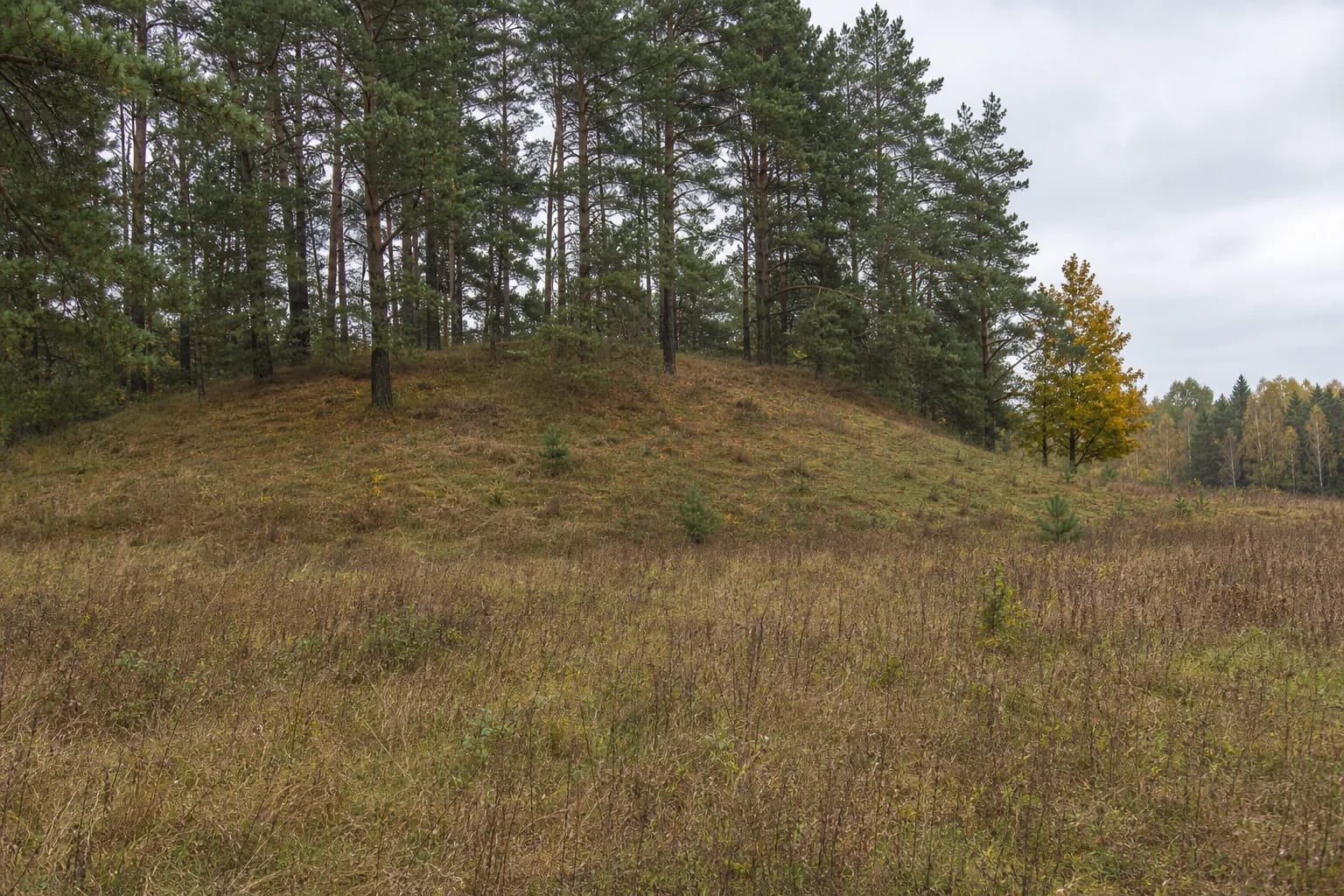
The hillfort occupies the northern end of an irregular elongated ridge. Its enclosure runs north-south, has a convex centre, and currently measures about 25 by 12 metres. The register's 2009 condition note says part of the enclosure lay fallow while sparse pines covered the rest.
A terrace about 2 metres wide lies on the northern slope, approximately 1.5 metres below the enclosure. Part of it has slipped, and trees and shrubs cover its surface. This is a narrow step in the slope and should not be renamed a bank. The current register description identifies neither a bank nor a defensive ditch at Atesninkai.
To the south, the hillfort rise joins the rest of the ridge, with a shallow natural depression at their junction. That feature should not automatically be called a defensive ditch either. Reading the monument on the ground means distinguishing three subtle forms: the convex enclosure, the narrow slipped terrace to the north, and the natural depression at the ridge connection.
Pines, shrubs, and tall grass conceal slopes no more than 7 metres high and several damaging pits
The slopes are moderately steep and no more than 7 metres high. The western slope is described as fairly steep, while the southern side rises only about 3 metres. From the field, the monument therefore appears as a rounded low ridge rather than a commanding fortress hill and can easily blend into the surrounding terrain.
Excavated pits have damaged the slopes, and part of the northern terrace has slipped. Register photographs taken in 2009 show a grassy ridge with scattered mature pines and shrubs beside open fallow ground. They show no steps, path, information panel, benches, fence, or reconstructed defences.
The current registered territory covers 13,339 square metres, or about 1.33 hectares. The register classifies this isolated monument as an individually registered site of regional significance for its archaeological and landscape character. The registered area is not the area of the enclosure and does not indicate where a visitor has a legal right to walk.
The first-half-of-the-first-millennium date is a broad chronology, not a castle narrative
The register dates Atesninkai Hillfort to the first half of the first millennium CE. This is an archaeological date range, not a known year of construction, siege, or abandonment. The current official records checked provide no castle name, ruler, battle, or written event that can be securely attached to this hill.
Alytus District Municipality's cultural centre reports that the Institute of History surveyed the hillfort in 1954 and observed neither fortifications nor a cultural deposit. A field survey is not the same as an extensive archaeological excavation. Failure to observe a deposit is also not proof that none could survive anywhere; it records the result of that particular inspection.
The current register record reports no archaeological finds, separately registered settlement at the foot, legend, or excavation results. Finds and traditions from nearby Bambininkai or Kaukai must therefore not be transferred to Atesninkai. The strongest account of this site rests on its surviving form and states clearly what the sources do not establish.
Official maps confirm the monument, but not a public route across the field
Atesninkai Hillfort appears as site 33583 in Alytus District's current list of visitor sites. The National Land Service's 2024 plan for the Kavalčiukai cadastral area also marks the hillfort beside Atesninkai I village. These documents confirm the identity and position of the monument, but inclusion on a list does not create a car park or public footpath.
The municipal cultural centre's route description ends with a walk of about 150 metres across a field. None of the sources checked confirms that this older description now follows a marked route, that the field is public, or that visitors may drive along the field track. The road categories shown on the land-service plan likewise do not by themselves establish a visitor's right to use a particular approach.
Use navigation only to locate the area. Leave a vehicle solely where parking is lawful and does not obstruct farm or residential access, never drive across cultivated or protected ground, and do not cross a field without clear permission. If no lawful marked approach is present, ask the municipality or landholder or postpone the visit. Official sources publish no opening hours, ticket, confirmed free-access policy, toilet, or accessible route, so check current arrangements with an official contact before travelling.