- Place
- Kazlų Rūda Municipality
- Region
- Suvalkija
- Type
- a forest viewpoint and rest area on the crest of an inland dune
- Address
- Raudonplynis Landscape Reserve, Kazlų Rūda, 69387 Kazlų Rūda Municipality
- Coordinates
- 54.83331, 23.53417
- Visit duration
- 30-60 minutes for the summit, survey marker, sandy dune ridge, and pine-forest relief
- Best time
- a dry day from spring to autumn; early spring and late autumn reveal the dune relief most clearly between the trees
Gairiakalnis Viewpoint, Gairiakalnis Viewing Area
A height of 96.1 metres marks the municipal summit, not a 96-metre slope
Kazlų Rūda Municipality's official visitor map identifies Gairiakalnis as the municipality's highest point at 96.1 m above Baltic Sea level. This is an absolute elevation, so visitors should not expect a mountain rising almost one hundred metres from its foot. What appears on the ground is a forest landscape of several sandy ridges and hollows.
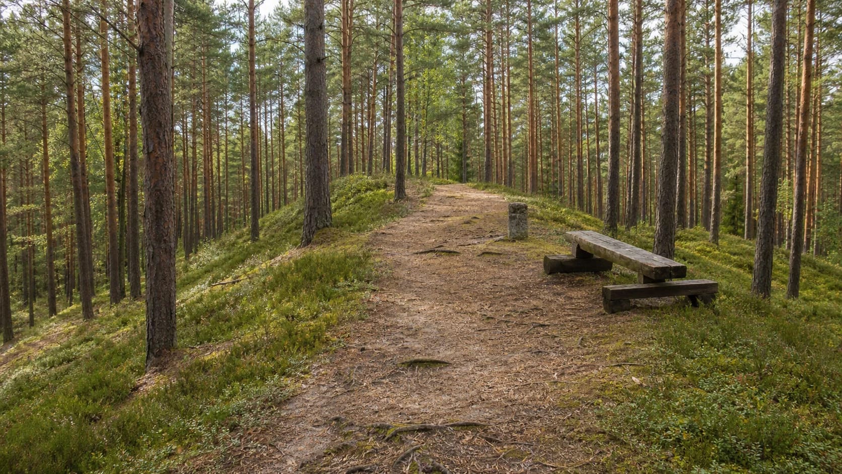
Gairiakalnis is described as a viewpoint, but there is no observation tower. Tall pines close off the distant horizon, while the revealing view is into the forest itself: trunks descend from the ridge, pale bands of sand expose the slope, and a path threads between them. This is a place for reading landform rather than photographing a town panorama.
The municipal page records a rest area for visitors at the top. Published photographs show simple timber benches, an information panel, a direction sign, and pedestrian-route marking. Forest furniture can be repaired, replaced, or temporarily removed, so the landscape should be the reason for a visit rather than one particular bench or sign.
Gairiakalnis rises within one of Raudonplynis's clearest inland-dune systems
Gairiakalnis stands inside Raudonplynis Landscape Reserve. The protected-areas register says the reserve was established in 1996, covers 654 ha, and protects a characteristic Kazlų Rūda landscape complex of inland dune ridges, including a particularly distinct dune fragment. The protected feature is the landform system as a whole, not only the highest-point clearing.
A 2020 special-planning document describes the Kazlų Rūda sand area as an ancient alluvial plain. Varved clays left by deep proglacial waters were later covered by river sediments, and after the water receded wind reworked the exposed sand. In the central part of the plain it accumulated as parabolic inland dunes.
The plan says the sand cover on these plains is generally 4-10 m thick and that the Kazlų Rūda dunes rise roughly 2-3 to 6-8 m above adjoining ground. Those measurements cannot be assigned mechanically to one Gairiakalnis slope. They do explain why ridges, hollows, and sharper sand edges keep appearing inside woodland that seems flat on a road map.
The dry pine ridge is only one part of a 654-hectare habitat mosaic
Real photographs of Gairiakalnis are dominated by Scots pines, a sandy trail surface, moss, bilberry ground cover, and more open patches on the dunes. In its wider account of the Kazlų Rūda sand plain, the reserve plan mentions spruce-rich pine woods, juniper, heather, bilberry, and lichens. The dry summit therefore differs sharply from lower hollows where water gathers.
The 2020 plan identified 76.31 ha of habitats of European Community importance across Raudonplynis Reserve. They include lichen pine forests, western taiga, coniferous forests on glaciofluvial ridges, bog woodland, alluvial forest, and alluvial meadows. This is a reserve-wide inventory, so visitors should not expect to find all seven habitat types beside the Gairiakalnis information panel.
Sandy slopes may look durable, but shortcuts loosen their surface and rain enlarges the resulting erosion channels. Stay on the existing route, do not take bicycles or motor vehicles onto a signed pedestrian section, and avoid stripping moss or lichen from the sand.
The 1924 marker connects the summit with Lithuania's triangulation history
The municipality's Gairiakalnis record says a geodetic marker, or benchmark, erected in 1924 survives on the summit and is associated with Lithuania's major triangulation. This is the only specifically dated episode in Gairiakalnis's history found in the official sources checked for this guide, so it should not be padded with unverified legends.
Lithuania's National Land Service explains a geodetic framework as a network of points fixed on the ground by special markers and assigned coordinates through precise measurement. Such points formed a coordinate skeleton for further surveying. The Gairiakalnis marker is best understood as a remnant of that measurement infrastructure rather than an ornamental forest monument.
Landscape protection came much later. Raudonplynis Reserve was established in 1996, and a 2020 special plan refined its boundaries and use rules. No reliable source checked for this page supports calling Gairiakalnis a hillfort, a sacred hill, or a separately protected natural heritage object. It is a visitor summit within a protected landscape reserve.
The exact map pin reaches the summit, but it does not promise a car park
The exact Google Maps listing Gairiakalnis, place ID ChIJl4qwE6LZ5kYRbVYrn0teijI, marks 54.8333132, 23.5341663. Coordinates 54.83343470082241, 23.534182314322095 on the municipal page lie only about a dozen metres away. Both identify the same summit area rather than the general centre of the reserve.
On 15 July 2026, the exact Google listing showed an average of 4.7 out of 5 from 115 reviews and marked the place open 24 hours. Municipal and protected-area pages publish neither a ticket fee nor formal opening hours. This is an open woodland site without a ticket desk, but a Google status is not a permanent guarantee. Check current information and signs before travelling.
No clearly designated Gairiakalnis car park or universally accessible path was found in the official sources checked. Navigation may lead along forest roads, and the final approach is safest planned on foot from a legal stopping place. Do not block a forest road, drive past prohibition signs, or rely solely on the shortest route proposed by an app.
An hour is enough for a focused visit if you stay on the marked forest route
Allow 30-60 minutes for the summit, the 1924 marker, the rest area, and several views along the dune ridge. In dry weather the route is mostly sandy, but roots, pine needles, and steeper edges can be slippery. Closed footwear is sensible. Although the map listing shows round-the-clock access, the relief is easiest to understand in daylight.
The sequence of dune ridges is easiest to see in early spring and late autumn, when low vegetation is sparser. In summer the strongest impression is the green pine and bilberry forest, but insect and tick protection is useful. After high winds, watch for damaged branches and do not enter areas that have been temporarily cordoned off.
The official reserve plan notes military training areas nearby. That does not mean the public Gairiakalnis rest area is automatically closed, but visitors should not wander beyond the marked route and must obey temporary warnings. Carry out all rubbish, light no fire outside a designated facility, and protect the fragile sand, moss, and lichen cover.